Location
Latitude: |
32-59-01.4000N (32.983722) |
Longitude: |
093-24-33.0000W (-93.409167) |
Elevation: |
217.6 feet MSL (66 m MSL) |
Magnetic Variation: |
0.6 E (as of April 2024 from WMM2020 model) |
Time Zone: |
UTC -6.0 (Standard Time) UTC -5.0 (Daylight Savings Time) |
From City: |
03 N.M. E of Springhill, Louisiana |
Found On: |
Memphis Chart |
FAA Region: |
ASW |
Contacts
Manager: |
Publicly owned: |
| STEVEN BURDEAUX P.O BOX 398 SPRINGHILL, LA 71075 318-453-7727 |
CITY OF SPRINGHILL MAYOR'S OFFICE, P.O. BOX 398 SPRINGHILL, LA 71075 318-539-5681 |
Operations
Airport Status: |
Operational |
Facility Use: |
Public |
Type: |
Airport |
Activation Date: |
01/1966 |
Control tower: |
No |
Attendance (Months/Days/Hours): |
Months/Days/Hours Unattended |
Boundary ARTCC: |
ZFW (Fort Worth) |
Responsible ARTCC: |
ZFW (Fort Worth) |
Lighting Schedule: |
SEE RMK |
Segmented Circle Indicator: |
No |
Traffic Pattern Altitude (MSL): |
1218 feet (371 m) |
NOTAMs Facility: |
DRI |
NOTAM-D Service: |
Yes |
International Airport of Entry: |
No |
Customs Landing Rights: |
No |
Military Landing Rights: |
No |
Civil/Military Joint Use: |
No |
Based Aircraft
| Single Engine: | 12 |
Annual Operations (as of 11/18/2020)
| Total Operations: | 6250 | |
| GA Local: | 3750 | 60.0% |
| GA Itinerant: | 2500 | 40.0% |
Communications
| CTAF: | 122.800 |
| Unicom: | 122.800 |
| Approach: | SHREVEPORT 123.75 123.75 |
| Departure: | SHREVEPORT 123.75 123.75 |
Fixed Based Operators (FBOs) & Fuel
(Click on a business for detail)
Please help us keep this information up to date. This is a FREE SERVICE just like everything else on Airport Guide! If you see that a business needs to be added, modified, or deleted please fill out our Update Form.
To add, modify, or delete a business click here.
Please help us keep this information up to date. This is a FREE SERVICE just like everything else on Airport Guide! If you see that a business needs to be added, modified, or deleted please fill out our Update Form.
Area Code: 318 |
| Business Name | Frequency | Phone | Fuel Grade |
|---|
Flight Service Stations
| Primary | Alternate | |
| FSS on Field: | N | |
| FSS Name (ID): | De Ridder(DRI) | |
| Frequency: | ||
| Toll Free Phone: | 1-800-WX-BRIEF |
Instrument Procedures / Charts
FAA Terminal Procedures valid from 0901Z 03/21/24 to 0901Z 04/18/24.
There are various types of charts available for an airport. They are listed in the Page Type column. Here is a legend for those types:
APD - Airport Diagram
DP - Departure Procedure Charts
HOT - Hot Spots
IAP - Instrument Approach Procedure Charts
MIN - Minimums
STAR - Standard Terminal Arrival Charts
| Page Type | Page Name | Volume | Action Since Last Cycle |
|---|---|---|---|
| IAP | RNAV (GPS) RWY 18 | SC-4 | |
| IAP | RNAV (GPS) RWY 36 | SC-4 | |
| MIN | TAKEOFF MINIMUMS | SC-4 |
Terminal Procedures are only available for airports in several countries with more being added all the time. If you are looking for a specific country's charts, please send an email to support(at)airportguide.com stating the country name. This will be used to prioritize the implementation.
Navigation Aids (Navaids) near KSPH
| Dist (NM) | ID | Morse Code | Name | Type | Freq | True Hdg | Mag Hdg |
|---|---|---|---|---|---|---|---|
| 23.9 | EIC | . . . _ . _ . | Belcher | VORTAC | 117.40 | 237 | 236 |
| 31.2 | VIV | . . . _ . . . . . _ | Vivian | NDB | 284 | 256 | 255 |
| 31.5 | DTN | _ . . _ _ . | Downtown | VOR | 108.60 | 212 | 211 |
| 31.6 | BAD | _ . . . . _ _ . . | Barksdale | TACAN | 115.80 | 204 | 203 |
| 36.2 | EMG | . _ _ _ _ . | Elm Grove | VORTAC | 111.20 | 195 | 194 |
| 37.2 | ELD | . . _ . . _ . . | El Dorado | VOR-DME | 115.50 | 63 | 63 |
| 38.7 | EL | . . _ . . | Lados | NDB | 418 | 61 | 61 |
| 38.7 | SHV | . . . . . . . . . . _ | Shreveport | VOT | 108.20 | 213 | 212 |
| 39.9 | ATA | . _ _ . _ | Atlanta | NDB | 347 | 280 | 279 |
| 40.9 | TX | _ _ . . _ | Tecco | NDB | 234 | 322 | 321 |
| 45.7 | HPC | . . . . . _ _ . _ . _ . | Hope | NDB | 362 | 344 | 343 |
| 46.1 | TXK | _ _ . . _ _ . _ | Texarkana | VORTAC | 116.30 | 313 | 312 |
| 47.1 | ROQ | . _ . _ _ _ _ _ . _ | Ruston | NDB | 368 | 118 | 118 |
| 53.9 | TUF | _ . . _ . . _ . | Stuckey | NDB | 350 | 129 | 129 |
| 58.0 | MSD | _ _ . . . _ . . | Mansfield | NDB | 414 | 198 | 197 |
| 58.2 | JBL | . _ _ _ _ . . . . _ . . | Hodge | NDB | 256 | 143 | 143 |
| 65.9 | RPF | . _ . . _ _ . . . _ . | Carthage | NDB | 332 | 223 | 222 |
| 66.1 | ADF | . _ _ . . . . _ . | Arkadelphia | NDB | 275 | 13 | 13 |
| 71.1 | SWB | . . . . _ _ _ . . . | Sawmill | VOR-DME | 113.75 | 148 | 148 |
| 73.1 | ML | _ _ . _ . . | Sabar | NDB | 392 | 115 | 115 |
Nearby Airports with Fuel
Notices to Airmen (NOTAMS)
Remarks
| A110-1 | FOR CD CTC FORT WORTH ARTCC AT 817-858-7584. |
| A110-2 | ULTRALIGHT ACTIVITY ON AND IN VICINITY OF AIRPORT |
| A43-18 | PAPI UNUSBL BYD 9 DEGS RIGHT OF CNTRLN. |
| A80 | AIRPORT BEACON LOCATED .52 MILES FROM THE APPROACH END RWY 18 RIGHT OF CENTERLINE |
| A81-APT | MIRL RWY 18/36 PRESET LOW INTST DUSK-DAWN; TO INCR INTST ACTVT - CTAF. |
Runways
Runway Summary
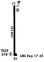
| Runways: | 18/36 |
| Longest Runway: | 18/36 is 4202 ft (1281 m) long |
| Runways with an Instrument Approach: |
KSPH Airport Runway Details
| Runway 18/36 | 4202 ft x 75 ft (1281 m x 23 m) | |
| Runway Length Source: | 3RD PARTY SURVEY as of 03/03/2015 | |
| Surface: | Asphalt - Good condition - No special surface treatment | |
| Runway Edge Lights: | Medium Intensity | |
Runway 18 |
Runway 36 |
|
Elevation: |
205.1 | 217.5 |
Latitude: |
32-59-22.1924N | 32-58-40.6239N |
Longitude: |
093-24-33.0685W | 093-24-32.9773W |
|
Runway True Alignment: |
180 | 360 |
Glide Path Angle: |
3.0 degrees | 3.0 degrees |
Runway Markings Type: |
Nonprecision Instrument | Nonprecision Instrument |
Runway Markings Condition: |
Good | Good |
Object at End: |
TREES | TREES |
Object Height: |
95 | 90 |
Distance from End: |
2158 | 2543 |
Object Centerline Offset: |
0 ft. left and right of centerline | 292 ft. right of centerline |
Visual Glide Slope Indicators: |
2-Light PAPI On Left Side Of Runway | 2-Light PAPI On Left Side Of Runway |
REIL: |
No | No |
Threshold Crossing Height: |
49 | 54 |
Services
Airframe Repair: |
None |
Powerplant Repair: |
None |
Fuel Available: |
100LL, Jet A |
Landing Fees: |
No |
Parking: |
Hangars and tiedowns available |
Maps & Diagrams
KSPH Sectional
Flight Planning
at skyvector.com
at skyvector.com