Location
Latitude: |
33-02-21.0000N (33.039167) |
Longitude: |
116-54-54.9000W (-116.91525) |
Elevation: |
1394.6 feet MSL (425 m MSL) |
Magnetic Variation: |
11 E (as of April 2024 from WMM2020 model) |
Time Zone: |
UTC -8.0 (Standard Time) UTC -7.0 (Daylight Savings Time) |
From City: |
02 N.M. W of Ramona, California |
Found On: |
Los Angeles Chart |
FAA Region: |
AWP |
Contacts
Manager: |
Publicly owned: |
| MEADOW CHASE 2926 MONTECITO ROAD RAMONA, CA 92065 760-788-3366 |
COUNTY OF SAN DIEGO 1960 JOE CROSSON DRIVE EL CAJON, CA 92020-1235 619-956-4800 |
Operations
Airport Status: |
Operational |
Facility Use: |
Public |
Type: |
Airport |
Activation Date: |
06/1947 |
Control tower: |
Yes |
Attendance (Months/Days/Hours): |
Months/Days/Hours ALL/ALL/0800-2000 |
Boundary ARTCC: |
ZLA (Los Angeles) |
Responsible ARTCC: |
ZLA (Los Angeles) |
Lighting Schedule: |
SEE RMK |
Segmented Circle Indicator: |
Yes |
Traffic Pattern Altitude (MSL): |
2395 feet (730 m) |
NOTAMs Facility: |
RNM |
NOTAM-D Service: |
Yes |
International Airport of Entry: |
No |
Customs Landing Rights: |
No |
Military Landing Rights: |
Yes |
Civil/Military Joint Use: |
No |
Based Aircraft
| Single Engine: | 121 |
| Multi Engine: | 10 |
| Jet Engine: | 1 |
| GA Helicopters: | 3 |
| Ultralights: | 2 |
Annual Operations (as of 12/31/2020)
| Total Operations: | 144979 | |
| GA Local: | 94236 | 65.0% |
| GA Itinerant: | 50018 | 34.5% |
| Military Aircraft: | 725 | 0.5% |
Communications
| CTAF: | 119.875 |
| Unicom: | 122.950 |
| Tower: | RAMONA 119.875 Hrs: 0800-2000 |
| Ground: | 121.65 |
| Approach: | SOCAL |
| Departure: | SOCAL |
| ATIS: | 132.025 Hrs: 24 |
| ASOS: | (760-789-7699) |
Fixed Based Operators (FBOs) & Fuel
(Click on a business for detail)
Please help us keep this information up to date. This is a FREE SERVICE just like everything else on Airport Guide! If you see that a business needs to be added, modified, or deleted please fill out our Update Form.
To add, modify, or delete a business click here.
Please help us keep this information up to date. This is a FREE SERVICE just like everything else on Airport Guide! If you see that a business needs to be added, modified, or deleted please fill out our Update Form.
Area Code: 760 |
| Business Name | Frequency | Phone | Fuel Grade |
|---|---|---|---|
| American Aircraft Interiors
Update FBO info |
788-9276 | ||
| Brown Aircraft
Update FBO info |
789-3593 | ||
| Chuck Hall Aviation
Update FBO info |
Unicom 122.7 | 789-8178 | 100LL, Jet A |
| Cruiseair Aviation
Update FBO info |
789-8020 | ||
| Pacific Executive Aviation
Update FBO info |
Unicom 122.7 | 789-6384 | 100LL |
| Ramona Avionics
Update FBO info |
788-0546 | ||
| Skyline Flight Academy
Update FBO info |
789-9313 |
Flight Service Stations
| Primary | Alternate | |
| FSS on Field: | N | |
| FSS Name (ID): | San Diego(SAN) | |
| Frequency: | ||
| Toll Free Phone: | 1-800-WX-BRIEF |
Instrument Procedures / Charts
FAA Terminal Procedures valid from 0901Z 03/21/24 to 0901Z 04/18/24.
There are various types of charts available for an airport. They are listed in the Page Type column. Here is a legend for those types:
APD - Airport Diagram
DP - Departure Procedure Charts
HOT - Hot Spots
IAP - Instrument Approach Procedure Charts
MIN - Minimums
STAR - Standard Terminal Arrival Charts
| Page Type | Page Name | Volume | Action Since Last Cycle |
|---|---|---|---|
| APD | AIRPORT DIAGRAM | SW-3 | |
| DP | CWARD TWO (RNAV) | SW-3 | |
| DP | PADRZ TWO (RNAV) | SW-3 | |
| IAP | RNAV (GPS) RWY 09 | SW-3 | |
| IAP | RNAV (GPS)-B | SW-3 | |
| IAP | VOR/DME-A | SW-3 | |
| MIN | ALTERNATE MINIMUMS | SW-3 | |
| MIN | TAKEOFF MINIMUMS | SW-3 |
Terminal Procedures are only available for airports in several countries with more being added all the time. If you are looking for a specific country's charts, please send an email to support(at)airportguide.com stating the country name. This will be used to prioritize the implementation.
Navigation Aids (Navaids) near KRNM
| Dist (NM) | ID | Morse Code | Name | Type | Freq | True Hdg | Mag Hdg |
|---|---|---|---|---|---|---|---|
| 13.2 | SEE | . . . . . | Gillespie Field | VOT | 110.00 | 193 | 182 |
| 15.8 | NKX | _ . _ . _ _ . . _ | Miramar | TACAN | 109.60 | 229 | 218 |
| 17.6 | JLI | . _ _ _ . _ . . . . | Julian | VORTAC | 114.00 | 69 | 58 |
| 20.8 | SAN | . . . . _ _ . | Mount Soledad | VOT | 109.00 | 234 | 223 |
| 21.9 | MZB | _ _ _ _ . . _ . . . | Mission Bay | VORTAC | 117.80 | 225 | 214 |
| 25.3 | NZY | _ . _ _ . . _ . _ _ | North Island | TACAN | 117.00 | 216 | 205 |
| 25.9 | PGY | . _ _ . _ _ . _ . _ _ | Poggi | VORTAC | 116.45 | 187 | 176 |
| 27.6 | NFG | _ . . . _ . _ _ . | Camp Pendleton | TACAN | 111.80 | 300 | 289 |
| 28.0 | OCN | _ _ _ _ . _ . _ . | Oceanside | VORTAC | 115.30 | 295 | 284 |
| 30.0 | TIJ | _ . . . _ _ _ | Tijuana | VOR-DME | 116.50 | 183 | 172 |
| 30.1 | NRS | _ . . _ . . . . | Imperial Beach | TACAN | 109.20 | 199 | 188 |
| 46.2 | HDF | . . . . _ . . . . _ . | Homeland | VOR | 112.05 | 343 | 332 |
| 51.8 | TRM | _ . _ . _ _ | Thermal | VORTAC | 116.20 | 46 | 35 |
| 55.1 | RIV | . _ . . . . . . _ | March | TACAN | 113.00 | 341 | 330 |
| 55.5 | PSP | . _ _ . . . . . _ _ . | Palm Springs | VORTAC | 115.50 | 25 | 14 |
| 56.0 | ELB | . . _ . . _ . . . | El Toro | VOR-DME | 117.20 | 313 | 302 |
| 61.1 | PDZ | . _ _ . _ . . _ _ . . | Paradise | VORTAC | 112.20 | 329 | 318 |
| 61.1 | RAL | . _ . . _ . _ . . | Riverside | VOR | 108.60 | 334 | 323 |
| 61.2 | SNA | . . . _ . . _ | Santa Ana | VOT | 110.00 | 308 | 297 |
| 63.4 | NJK | _ . . _ _ _ _ . _ | El Centro | TACAN | 111.00 | 100 | 89 |
Nearby Airports with Fuel
Notices to Airmen (NOTAMS)
Remarks
| A110*G | THIS AIRPORT HAS BEEN SURVEYED BY THE NATIONAL GEODETIC SURVEY. |
| A110-1 | HELIPAD PRKG N OF RWY NOT OPEN TO PUB. |
| A110-10 | WHEN TWR CLSD ACFT MUST SELF-ANNOUNCE ON CTAF PRIOR TO LDG OR TKOF. |
| A110-11 | PPR FOR ALL MIL ACFT CTC AMGR. |
| A110-12 | COPTER SKID LNDGS ON RWY AND TWY PROHIBITED. |
| A110-13 | HEL OPS TO HELIPAD S OF RWY RSTRD TO 6000 LBS OR LESS. |
| A110-14 | REPETITIVE COPTER TRG CONDUCTED ON HELIPAD S OF RWY AND TWY A W OF TWR. |
| A110-15 | HELIPAD S OF RWY UNLGTD. |
| A110-16 | HELIPAD S OF RWY DAYTIME VFR USE ONLY. |
| A110-17 | FOR CD WHEN ATCT CLSD CTC SOCAL APCH AT 800-448-3724. |
| A110-18 | WEST TSNT RAMP ADJ TO ATCT RSTRD TO ACFT LESS THAN 12500 LBS. |
| A110-2 | VOLUNTARY JET CURFEW 2200-0700. NOISE SENSITIVE AREA NE-SE. NOISE ABATEMENT: TKOF CLIMB ON RWY HDG UNTIL 1900 FT MSL. |
| A110-3 | FIRE FIGHTING ACFT ON AND IN THE VICINITY OF ARPT. |
| A110-4 | AIR TANKERS IN VCNTY YEAR-ROUND FRQLY FLY NONSTD PAT ENTRIES. |
| A110-5 | RWY 27 CALM WIND RWY. |
| A110-6 | FOR FIRE FIGHTING ACTIVITY CALL AMGR. |
| A110-8 | BE ALERT FOR BIRDS YEAR ROUND, VARIOUS SIZE AND SPECIES. OCNL COYOTE ON OR IN THE VICINITY OF RWY AND TWY. |
| A16 | ARPT MGR: CAN ALSO BE REACHED AT FALLBROOK COMMUNITY AIRPARK 760-723-8395. |
| A43-09 | UNUSBL BYD 3.0 NM DUE TO TRRN. |
| A81-APT | ACTVT REIL RWY 27; MIRL RWY 09/27; TWY LGTS - CTAF. PAPI RWY 09 & 27 OPER 24 HRS. |
| E147 | 1000 FT SNGL ENG, 1500 FT MULT ENG. |
Runways
Runway Summary
| Runways: | 09/27 H1 |
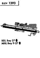
| Longest Runway: | 09/27 is 5001 ft (1524 m) long |
| Runways with an Instrument Approach: |
KRNM Airport Runway Details
| Runway 09/27 | 5001 ft x 150 ft (1524 m x 46 m) | |
| Runway Length Source: | NGS as of 02/01/2009 | |
| Surface: | Asphalt - Good condition - No special surface treatment | |
| Runway Edge Lights: | Medium Intensity | |
Runway Weight Bearing Capacity (in thousands of pounds) |
||
| Single Wheel Landing Gear: | 75.0 | |
| Dual Wheel Landing Gear: | 95.0 | |
| Dual Tandem Wheel Landing Gear: | 170.0 | |
Runway 09 |
Runway 27 |
|
Elevation: |
1385.8 | 1394.5 |
Latitude: |
33-02-25.2425N | 33-02-16.6840N |
Longitude: |
116-55-23.8455W | 116-54-25.9941W |
|
Runway True Alignment: |
099 | 279 |
Glide Path Angle: |
3.5 degrees | 3.5 degrees |
Traffic Pattern: |
Left | Left |
Runway Markings Type: |
Nonprecision Instrument | Nonprecision Instrument |
Runway Markings Condition: |
Good | Good |
Visual Glide Slope Indicators: |
2-Light PAPI On Left Side Of Runway | 2-Light PAPI On Left Side Of Runway |
REIL: |
No | Yes |
Touchdown Lights: |
No | No |
Centerline Lights: |
No | No |
Threshold Crossing Height: |
51 | 32 |
| Helipad H1 | 340 ft x 66 ft (104 m x 20 m) | |
| Surface: | Asphalt - Good condition - No special surface treatment | |
Helipad H1 |
||
Elevation: |
1391.0 | |
Latitude: |
33-02-16.9800N | |
Longitude: |
116-54-50.9500W | |
Glide Path Angle: |
0.0 degrees | 0.0 degrees |
Services
Airframe Repair: |
Major |
Powerplant Repair: |
Major |
Bottled Oxygen: |
None |
Bulk Oxygen: |
High Pressure / Low Pressure |
Fuel Available: |
100LL |
Landing Fees: |
No |
Parking: |
Tiedowns available |
Maps & Diagrams
KRNM Sectional
Flight Planning
at skyvector.com
at skyvector.com