Location
Latitude: |
64-56-22.3000N (64.939528) |
Longitude: |
161-09-15.4000W (-161.154278) |
Elevation: |
161.5 feet MSL (49 m MSL) |
Magnetic Variation: |
9.9 E (as of April 2024 from WMM2020 model) |
Time Zone: |
UTC -9.0 (Standard Time) UTC -8.0 (Daylight Savings Time) |
From City: |
00 N.M. NE of Koyuk, Alaska |
Found On: |
Nome Chart |
FAA Region: |
AAL |
Contacts
Manager: |
Publicly owned: |
| JOHN WILSON PO BOX 192 UNALAKLEET, AK 99684 (907) 625-1025 |
ALASKA DOT&PF NORTHERN REGION 2301 PEGER RD FAIRBANKS, AK 99709 907-451-2200 |
Operations
Airport Status: |
Operational |
Facility Use: |
Public |
Type: |
Airport |
Activation Date: |
09/1952 |
Control tower: |
No |
Attendance (Months/Days/Hours): |
Months/Days/Hours Unattended |
Boundary ARTCC: |
ZAN (Anchorage) |
Responsible ARTCC: |
ZAN (Anchorage) |
Lighting Schedule: |
SEE RMK |
Segmented Circle Indicator: |
Yes |
Traffic Pattern Altitude (MSL): |
1162 feet (354 m) |
NOTAMs Facility: |
KKA |
NOTAM-D Service: |
Yes |
International Airport of Entry: |
No |
Customs Landing Rights: |
No |
Military Landing Rights: |
Yes |
Civil/Military Joint Use: |
No |
Based Aircraft
Annual Operations (as of 12/31/2022)
| Total Operations: | 1000 | |
| Air Taxi: | 1000 | 100.0% |
Communications
| CTAF: | 122.800 |
| AWOS-3P: | 134.95 (907-963-4000) |
- APCH/DEP SVC PRVDD BY ANCHORAGE ARTCC ON FREQS 135.7/335.5 (UNALAKLEET RCAG).
- COMMUNICATIONS PRVDD BY NOME FSS ON FREQ 122.35 (KOYUK RCO).
Fixed Based Operators (FBOs) & Fuel
(Click on a business for detail)
Please help us keep this information up to date. This is a FREE SERVICE just like everything else on Airport Guide! If you see that a business needs to be added, modified, or deleted please fill out our Update Form.
To add, modify, or delete a business click here.
Please help us keep this information up to date. This is a FREE SERVICE just like everything else on Airport Guide! If you see that a business needs to be added, modified, or deleted please fill out our Update Form.
Area Code: 907 |
| Business Name | Frequency | Phone | Fuel Grade |
|---|
Flight Service Stations
| Primary | Alternate | |
| FSS on Field: | N | |
| FSS Name (ID): | Nome(OME) | Fairbanks (FAI) |
| Frequency: | ||
| Toll Free Phone: | 1-800-478-8400 | 1-866-248-6516 |
Instrument Procedures / Charts
FAA Terminal Procedures valid from 0901Z 03/21/24 to 0901Z 04/18/24.
There are various types of charts available for an airport. They are listed in the Page Type column. Here is a legend for those types:
APD - Airport Diagram
DP - Departure Procedure Charts
HOT - Hot Spots
IAP - Instrument Approach Procedure Charts
MIN - Minimums
STAR - Standard Terminal Arrival Charts
| Page Type | Page Name | Volume | Action Since Last Cycle |
|---|---|---|---|
| IAP | RNAV (GPS) RWY 01 | AK-1 | Changed |
| MIN | TAKEOFF MINIMUMS | AK-1 |
Terminal Procedures are only available for airports in several countries with more being added all the time. If you are looking for a specific country's charts, please send an email to support(at)airportguide.com stating the country name. This will be used to prioritize the implementation.
Navigation Aids (Navaids) near KKA
| Dist (NM) | ID | Morse Code | Name | Type | Freq | True Hdg | Mag Hdg |
|---|---|---|---|---|---|---|---|
| 0.2 | KKA | _ . _ _ . _ . _ | Koyuk | NDB-DME | 299 | 186 | 176 |
| 27.4 | OAY | _ _ _ . _ _ . _ _ | Norton Bay | NDB | 263 | 238 | 228 |
| 27.6 | MOS | _ _ _ _ _ . . . | Moses Point | VOR-DME | 116.30 | 238 | 228 |
| 62.4 | BVK | _ . . . . . . _ _ . _ | Buckland | NDB-DME | 325 | 0 | 350 |
| 62.5 | JNR | . _ _ _ _ . . _ . | North River | NDB | 382 | 171 | 161 |
| 64.0 | UNK | . . _ _ . _ . _ | Unalakleet | VOR-DME | 116.90 | 168 | 158 |
Nearby Airports with Fuel
| Dist (NM) | Name (Airport IDs) | True Hdg | Mag Hdg | Fuel Grade |
|---|
Notices to Airmen (NOTAMS)
Remarks
| A110-1 | RWY COND UNMNT; RCMD VISUAL INSP PRIOR TO LNDG. |
| A110-2 | TURB ON APCH WHEN WIND FM NW. |
| A110-4 | WX CAMERA AVBL ON INTERNET AT HTTPS://WEATHERCAMS.FAA.GOV |
| A33-01/19 | GRAVEL-DIRT. |
| A42-01 | LGTS, CONES & THR PANELS. |
| A42-19 | LGTS, CONES & THR PANELS. |
| A81-APT | ACTVT MIRL RWY 01/19 - CTAF. VASI RWY 01 & 19 ON CONSLY. |
Runways
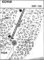
Runway Summary
| Runways: | 01/19 |
| Longest Runway: | 01/19 is 3002 ft (915 m) long |
| Runways with an Instrument Approach: |
KKA Airport Runway Details
| Runway 01/19 | 3002 ft x 60 ft (915 m x 18 m) | |
| Runway Length Source: | 3RD PARTY SURVEY as of 06/11/2012 | |
| Surface: | Gravel - Good condition - No special surface treatment | |
| Runway Edge Lights: | Medium Intensity | |
Runway 01 |
Runway 19 |
|
Elevation: |
159.8 | 152.6 |
Latitude: |
64-56-08.7610N | 64-56-35.7620N |
Longitude: |
161-09-29.5070W | 161-09-01.2050W |
|
Runway True Alignment: |
024 | 204 |
Glide Path Angle: |
3.0 degrees | 4.0 degrees |
Traffic Pattern: |
Left | Left |
Runway Markings Type: |
Nonstandard (other than numbers only) | Nonstandard (other than numbers only) |
Runway Markings Condition: |
Fair | Fair |
Object at End: |
BRUSH | BRUSH |
Object Height: |
13 | 5 |
Distance from End: |
0 | 0 |
Object Centerline Offset: |
220 ft. left of centerline | 47 ft. left of centerline |
Visual Glide Slope Indicators: |
4-Box VASI On Left Side Of Runway | 4-Box VASI On Right Side Of Runway |
Threshold Crossing Height: |
25 | 32 |
Services
Landing Fees: |
No |
Maps & Diagrams
KKA Sectional
Flight Planning
at skyvector.com
at skyvector.com