Location
Latitude: |
31-12-47.4000N (31.213167) |
Longitude: |
084-14-06.8000W (-84.235222) |
Elevation: |
176.4 feet MSL (54 m MSL) |
Magnetic Variation: |
5.3 W (as of April 2024 from WMM2020 model) |
Time Zone: |
UTC -5.0 (Standard Time) UTC -4.0 (Daylight Savings Time) |
From City: |
02 N.M. SW of Camilla, Georgia |
Found On: |
Jacksonville Chart |
FAA Region: |
ASO |
Contacts
Manager: |
Publicly owned: |
| NICHOLAS WRIGHT 3907 AIRPORT ROAD CAMILLA, GA 31730 229-336-2216 |
CITY OF CAMILLA BOX 328 CAMILLA, GA 31730 229-336-2222 |
Operations
Airport Status: |
Operational |
Facility Use: |
Public |
Type: |
Airport |
Activation Date: |
06/1947 |
Control tower: |
No |
Attendance (Months/Days/Hours): |
Months/Days/Hours ALL/MON-SAT/0800-1700 |
Boundary ARTCC: |
ZJX (Jacksonville) |
Responsible ARTCC: |
ZJX (Jacksonville) |
Lighting Schedule: |
SEE RMK |
Segmented Circle Indicator: |
Yes |
Traffic Pattern Altitude (MSL): |
1176 feet (358 m) |
NOTAMs Facility: |
MCN |
NOTAM-D Service: |
Yes |
International Airport of Entry: |
No |
Customs Landing Rights: |
No |
Military Landing Rights: |
Yes |
Civil/Military Joint Use: |
No |
Based Aircraft
| Single Engine: | 25 |
| Multi Engine: | 2 |
Annual Operations (as of 12/31/2023)
| Total Operations: | 12000 | |
| GA Local: | 10000 | 83.3% |
| GA Itinerant: | 2000 | 16.7% |
Communications
| CTAF: | 122.800 |
| Unicom: | 122.800 |
| AWOS-3T: | 118.675 (229-336-0744) |
- APCH/DEP SVC PRVDD BY JAX ARTCC ON FREQS 125.75/363.075 (ALBANY RCAG).
Fixed Based Operators (FBOs) & Fuel
(Click on a business for detail)
Please help us keep this information up to date. This is a FREE SERVICE just like everything else on Airport Guide! If you see that a business needs to be added, modified, or deleted please fill out our Update Form.
To add, modify, or delete a business click here.
Please help us keep this information up to date. This is a FREE SERVICE just like everything else on Airport Guide! If you see that a business needs to be added, modified, or deleted please fill out our Update Form.
Area Code: 912 |
| Business Name | Frequency | Phone | Fuel Grade |
|---|---|---|---|
| Hailey Aviation
Update FBO info |
Unicom 122.8 | 336-2216 | 100LL |
Flight Service Stations
| Primary | Alternate | |
| FSS on Field: | N | |
| FSS Name (ID): | Macon(MCN) | |
| Frequency: | ||
| Toll Free Phone: | 1-800-WX-BRIEF |
Instrument Procedures / Charts
FAA Terminal Procedures valid from 0901Z 03/21/24 to 0901Z 04/18/24.
There are various types of charts available for an airport. They are listed in the Page Type column. Here is a legend for those types:
APD - Airport Diagram
DP - Departure Procedure Charts
HOT - Hot Spots
IAP - Instrument Approach Procedure Charts
MIN - Minimums
STAR - Standard Terminal Arrival Charts
| Page Type | Page Name | Volume | Action Since Last Cycle |
|---|---|---|---|
| IAP | RNAV (GPS) RWY 08 | SE-4 | |
| IAP | RNAV (GPS) RWY 26 | SE-4 | |
| MIN | TAKEOFF MINIMUMS | SE-4 |
Terminal Procedures are only available for airports in several countries with more being added all the time. If you are looking for a specific country's charts, please send an email to support(at)airportguide.com stating the country name. This will be used to prioritize the implementation.
Navigation Aids (Navaids) near KCXU
| Dist (NM) | ID | Morse Code | Name | Type | Freq | True Hdg | Mag Hdg |
|---|---|---|---|---|---|---|---|
| 0.1 | CXU | _ . _ . _ . . _ . . _ | Camilla | NDB | 369 | 313 | 318 |
| 14.7 | AB | . _ _ . . . | Putny | NDB | 227 | 351 | 356 |
| 19.9 | CYR | _ . _ . _ . _ _ . _ . | Caidy | NDB | 338 | 168 | 173 |
| 20.7 | LYZ | . _ . . _ . _ _ _ _ . . | Willis | NDB | 359 | 225 | 230 |
| 23.5 | MGR | _ _ _ _ . . _ . | Moultrie | DME | 108.8 | 109 | 114 |
| 26.0 | GTP | _ _ . _ . _ _ . | Paton | NDB | 245 | 126 | 131 |
| 26.7 | PZD | . _ _ . _ _ . . _ . . | Pecan | VOR-DME | 116.10 | 353 | 358 |
| 33.3 | IWJ | . . . _ _ . _ _ _ | Blaak | NDB | 344 | 296 | 301 |
| 40.1 | SZW | . . . _ _ . . . _ _ | Seminole | VORTAC | 117.50 | 190 | 195 |
| 40.4 | IFM | . . . . _ . _ _ | Tift Myers | VOR | 112.50 | 71 | 77 |
| 41.6 | TM | _ _ _ | Tifto | NDB | 409 | 77 | 83 |
| 46.0 | GEF | _ _ . . . . _ . | Greenville | VORTAC | 113.65 | 149 | 154 |
| 50.0 | TLH | _ . _ . . . . . . | Tallahassee Muni | VOT | 111.00 | 187 | 192 |
| 50.8 | OHY | _ _ _ . . . . _ . _ _ | Coney | NDB | 400 | 21 | 27 |
| 52.4 | MAI | _ _ . _ . . | Marianna | VORTAC | 114.00 | 240 | 245 |
| 53.6 | TL | _ . _ . . | Wakul | NDB | 379 | 186 | 191 |
| 54.0 | SUR | . . . . . _ . _ . | Fitzgerald | NDB | 362 | 63 | 69 |
| 54.9 | SMY | . . . _ _ _ . _ _ | Soyya | NDB | 329 | 248 | 253 |
| 55.6 | OTK | _ _ _ _ _ . _ | Valdosta | VOR-DME | 114.80 | 117 | 123 |
| 55.6 | VAD | . . . _ . _ _ . . | Moody | TACAN | 113.30 | 105 | 111 |
Nearby Airports with Fuel
Notices to Airmen (NOTAMS)
Remarks
| A110-1 | FOR CD CTC JACKSONVILLE ARTCC AT 904-845-1592. |
| A81-APT | REIL RWY 08 & 26; PAPI RWY 08 & 26; AND MIRL RWY 08/26 OPR DUSK TO 2130. AFT 2130 ACTVT - CTAF. |
Runways
Runway Summary
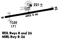
| Runways: | 08/26 |
| Longest Runway: | 08/26 is 5004 ft (1525 m) long |
| Runways with an Instrument Approach: |
KCXU Airport Runway Details
| Runway 08/26 | 5004 ft x 100 ft (1525 m x 30 m) | |
| Runway Length Source: | 3RD PARTY SURVEY as of 07/08/2011 | |
| Surface: | Asphalt - Good condition - No special surface treatment | |
| Runway Edge Lights: | Medium Intensity | |
Runway Weight Bearing Capacity (in thousands of pounds) |
||
| Single Wheel Landing Gear: | 30.0 | |
| Dual Wheel Landing Gear: | 52.0 | |
| Dual Tandem Wheel Landing Gear: | 85.0 | |
Runway 08 |
Runway 26 |
|
Elevation: |
167.9 | 176.4 |
Latitude: |
31-12-42.7254N | 31-12-52.1362N |
Longitude: |
084-14-35.1318W | 084-13-38.5570W |
|
Runway True Alignment: |
079 | 259 |
Glide Path Angle: |
3.0 degrees | 3.0 degrees |
Traffic Pattern: |
Left | Left |
Runway Markings Type: |
Nonprecision Instrument | Nonprecision Instrument |
Runway Markings Condition: |
Fair | Fair |
Object at End: |
TREES | |
Object Height: |
75 | |
Distance from End: |
1850 | |
Object Centerline Offset: |
230 ft. left of centerline | |
Visual Glide Slope Indicators: |
2-Light PAPI On Left Side Of Runway | 2-Light PAPI On Left Side Of Runway |
REIL: |
Yes | Yes |
Threshold Crossing Height: |
39 | 39 |
Services
Airframe Repair: |
None |
Powerplant Repair: |
None |
Bottled Oxygen: |
None |
Bulk Oxygen: |
None |
Fuel Available: |
100LL, Jet A+ |
Landing Fees: |
No |
Parking: |
Hangars and tiedowns available |
Maps & Diagrams
KCXU Sectional
Flight Planning
at skyvector.com
at skyvector.com