Location
Latitude: |
34-12-49.5300N (34.213758) |
Longitude: |
119-05-39.6750W (-119.094354) |
Elevation: |
76.8 feet MSL (23 m MSL) |
Magnetic Variation: |
11.7 E (as of April 2024 from WMM2020 model) |
Time Zone: |
UTC -8.0 (Standard Time) UTC -7.0 (Daylight Savings Time) |
From City: |
03 N.M. W of Camarillo, California |
Found On: |
Los Angeles Chart |
FAA Region: |
AWP |
Contacts
Manager: |
Publicly owned: |
| KEITH FREITAS 555 AIRPORT WAY, SUITE B CAMARILLO, CA 93010-8544 805-388-4372 |
COUNTY OF VENTURA 555 AIRPORT WAY CAMARILLO, CA 93010-8544 805-388-4372 |
Operations
Airport Status: |
Operational |
Facility Use: |
Public |
Type: |
Airport |
Activation Date: |
12/1976 |
Control tower: |
Yes |
Attendance (Months/Days/Hours): |
Months/Days/Hours ALL/ALL/0700-2300 |
Boundary ARTCC: |
ZLA (Los Angeles) |
Responsible ARTCC: |
ZLA (Los Angeles) |
Lighting Schedule: |
SEE RMK |
Segmented Circle Indicator: |
Yes |
Traffic Pattern Altitude (MSL): |
1077 feet (328 m) |
NOTAMs Facility: |
CMA |
NOTAM-D Service: |
Yes |
International Airport of Entry: |
No |
Customs Landing Rights: |
No |
Based Aircraft
| Single Engine: | 301 |
| Multi Engine: | 35 |
| Jet Engine: | 24 |
| GA Helicopters: | 22 |
| Gliders: | 1 |
Annual Operations (as of 06/28/2023)
| Total Operations: | 108566 | |
| Air Taxi: | 2460 | 2.3% |
| GA Local: | 34009 | 31.3% |
| GA Itinerant: | 68443 | 63.0% |
| Military Aircraft: | 3654 | 3.4% |
Communications
| CTAF: | 128.200 |
| Unicom: | 122.950 |
| Tower: | CAMARILLO 128.2 269.4 Hrs: 0700-2100 |
| Clearance Del.: | 120.75 ;2100-2300, POINT MUGU NAS 121.8 ;0700-2100 120.75 120.75 120.75 120.75 120.75 120.75 |
| Ground: | 121.8 |
| Approach: | POINT MUGU L.A. CENTER ARTCC |
| Departure: | POINT MUGU L.A. CENTER ARTCC |
| ATIS: | 126.025 Hrs: 24 |
| ASOS: | 126.025 (805-384-9294) |
- APCH/DEP CTL SVC PRVDD BY LOS ANGELES ARTCC (ZLA) ON FREQS 135.5/327.1 (SANTA BARBARA RCAG) WHEN POINT MUGU APCH CTL (NTD) CLSD.
- FOR AFTR HRS IFR CLNC DEL CTC LOS ANGELES ARTCC 661 575-2052.
Fixed Based Operators (FBOs) & Fuel
(Click on a business for detail)
Please help us keep this information up to date. This is a FREE SERVICE just like everything else on Airport Guide! If you see that a business needs to be added, modified, or deleted please fill out our Update Form.
To add, modify, or delete a business click here.
Please help us keep this information up to date. This is a FREE SERVICE just like everything else on Airport Guide! If you see that a business needs to be added, modified, or deleted please fill out our Update Form.
Area Code: 805 |
| Business Name | Frequency | Phone | Fuel Grade |
|---|---|---|---|
| Air 7, LLC
Website Update FBO info |
130.8 Unicom | 805-383-1100 | |
| Avex, Inc.
Update FBO info |
389-1188 | ||
| California Executive Charter
Update FBO info |
388-1322 | ||
| Camarillo Aircraft Services
Update FBO info |
388-1322 | ||
| Channel Islands Aviation
Update FBO info |
Unicom 123.3, Arinc 129.1 | 987-1301 | 100LL, Jet A |
| Heidi's Place Pilot Shop
Update FBO info |
482-2586 | ||
| Southern Cross Aviation
Update FBO info |
388-4778 | ||
| Sun Air Aviation
Website Update FBO info |
Unicom 122.95, ARINC 130.75 | 987-8464 | 100LL, Jet A |

|
Unknown | 100LL - 5.90 USD per gallon on 02/07/2024 |
Trucks |
|
|
Unknown | Jet A - 4.94 USD per gallon on 02/07/2024 |
Trucks |
| Sun Air Jets
Website Update FBO info |
805-243-3952 | ||
| Western Cardinal, Inc.
Update FBO info |
Unicom 123.5 | 482-2586 | 100LL, Jet A |
Flight Service Stations
| Primary | Alternate | |
| FSS on Field: | N | |
| FSS Name (ID): | Hawthorne(HHR) | |
| Frequency: | ||
| Toll Free Phone: | 1-800-WX-BRIEF |
Instrument Procedures / Charts
FAA Terminal Procedures valid from 0901Z 03/21/24 to 0901Z 04/18/24.
There are various types of charts available for an airport. They are listed in the Page Type column. Here is a legend for those types:
APD - Airport Diagram
DP - Departure Procedure Charts
HOT - Hot Spots
IAP - Instrument Approach Procedure Charts
MIN - Minimums
STAR - Standard Terminal Arrival Charts
| Page Type | Page Name | Volume | Action Since Last Cycle |
|---|---|---|---|
| APD | AIRPORT DIAGRAM | SW-3 | |
| IAP | RNAV (GPS) RWY 08 | SW-3 | |
| IAP | RNAV (GPS) Y RWY 26 | SW-3 | |
| IAP | RNAV (GPS) Z RWY 26 | SW-3 | |
| IAP | VOR RWY 26 | SW-3 | |
| MIN | ALTERNATE MINIMUMS | SW-3 | |
| MIN | TAKEOFF MINIMUMS | SW-3 | |
| STAR | GUERA TWO (RNAV) | SW-3 | |
| STAR | GUERA TWO (RNAV)[DELIMITER] CONT.1 | SW-3 |
Terminal Procedures are only available for airports in several countries with more being added all the time. If you are looking for a specific country's charts, please send an email to support(at)airportguide.com stating the country name. This will be used to prioritize the implementation.
Navigation Aids (Navaids) near KCMA
| Dist (NM) | ID | Morse Code | Name | Type | Freq | True Hdg | Mag Hdg |
|---|---|---|---|---|---|---|---|
| 0.1 | CMA | _ . _ . _ _ . _ | Camarillo | VOR-DME | 115.80 | 181 | 169 |
| 5.6 | NTD | _ . _ _ . . | Point Mugu | TACAN | 110.60 | 194 | 182 |
| 6.3 | VTU | . . . _ _ . . _ | Ventura | VOR-DME | 108.20 | 159 | 147 |
| 13.6 | FIM | . . _ . . . _ _ | Fillmore | VORTAC | 112.50 | 50 | 38 |
| 29.9 | VNY | . . . _ _ . _ . _ _ | Van Nuys | VOR-DME | 113.10 | 88 | 76 |
| 33.9 | PAI | . _ _ . . _ . . | Pacoima | NDB | 370 | 85 | 73 |
| 33.9 | SMO | . . . _ _ _ _ _ | Santa Monica | VOR-DME | 110.80 | 110 | 98 |
| 35.6 | UR | . . _ . _ . | Vinee | NDB | 253 | 91 | 79 |
| 37.0 | LAX | . _ . . . _ _ . . _ | Los Angeles | VORTAC | 113.60 | 116 | 104 |
| 37.2 | GMN | _ _ . _ _ _ . | Gorman | VORTAC | 116.10 | 17 | 5 |
| 37.9 | RZS | . _ . _ _ . . . . . | San Marcus | VORTAC | 114.90 | 298 | 286 |
| 38.1 | LHS | . _ . . . . . . . . . | Lake Hughes | VORTAC | 114.35 | 42 | 30 |
| 46.4 | CPM | _ . _ . . _ _ . _ _ | Compton | NDB | 378 | 114 | 102 |
| 47.0 | LAX | . _ . . . _ _ . . _ | San Pedro Hill | VOT | 113.90 | 126 | 114 |
| 52.9 | GVO | _ _ . . . . _ _ _ _ | Gaviota | VORTAC | 113.80 | 291 | 279 |
| 53.3 | EMT | . _ _ _ | El Monte | NDB | 359 | 97 | 85 |
| 56.8 | PMD | . _ _ . _ _ _ . . | Palmdale | VORTAC | 114.50 | 63 | 51 |
| 57.6 | LG | . _ . . _ _ . | Becca | NDB | 233 | 118 | 106 |
| 57.8 | SLI | . . . . _ . . . . | Seal Beach | VORTAC | 115.70 | 116 | 104 |
| 60.5 | SXC | . . . _ . . _ _ . _ . | Santa Catalina | VORTAC | 114.15 | 146 | 134 |
Nearby Airports with Fuel
Notices to Airmen (NOTAMS)
Remarks
| A110-1 | UNLGTD MTN 1173 FT MSL; BEGINNING 5 MILES FM EAST END RY 26. UNLGTD MTN 1814 FT MSL 5 MILES TO ESE OF APCH END RY 26. |
| A110-10 | NO FORMATION TKOFS OR LDGS. |
| A110-14 | NO TAKEOFFS 0000-0500 LOCAL TIME (WITHOUT PRIOR PERMISSION). |
| A110-15 | HEL TRNG PADS TO THE N OF TWY B AND RY 8/26. |
| A110-16 | UPON ARR CTC FBO OR ARPT OPS 805-947-6803 FOR ASSISTANCE. |
| A110-2 | WILDLIFE ON AND INVOF ARPT. |
| A110-3 | NO LDGS/TAXIING/TKOFS ON CHEVERONED AREA EAST OF RY 26 THR. |
| A110-4 | NOISE SENSITIVE ALL QUADRANTS PRACTICE NOISE ABATEMENT/FLY QUIET/PROCS. |
| A110-6 | BE ALERT TO HIGH PERFORMANCE MIL ACFT OPNS INVOF ARPT. |
| A24 | |
| A70-FUEL-10 | 0LL FUEL AVBL 24 HRS SELF SERVE. |
| A81-APT | WHEN ATCT CLSD ACTVT MIRL RY 08/26, REIL RYS 08 AND 26 AND PAPI RYS 8 AND 26 - CTAF. |
| A96 | ULTRALIGHT ACTIVITY SW QUAD OF ARPT. |
| E147 | TPA SINGLE ENGINE 800 FT AGL; MULTI ENGINE AND JETS 1000 FT AGL. |
Runways
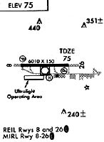
Runway Summary
| Runways: | 08/26 |
| Longest Runway: | 08/26 is 6013 ft (1833 m) long |
| Runways with an Instrument Approach: |
KCMA Airport Runway Details
| Runway 08/26 | 6013 ft x 150 ft (1833 m x 46 m) | |
| Runway Length Source: | 3RD PARTY SURVEY as of 02/04/2021 | |
| Surface: | Asphalt/Concrete - Good condition - Rubberized friction seal coat | |
| Runway Edge Lights: | Medium Intensity | |
Runway Weight Bearing Capacity (in thousands of pounds) |
||
| Single Wheel Landing Gear: | 50.0 | |
| Dual Wheel Landing Gear: | 80.0 | |
| Dual Tandem Wheel Landing Gear: | 125.0 | |
Runway 08 |
Runway 26 |
|
Elevation: |
63.1 | 76.8 |
Latitude: |
34-12-49.8195N | 34-12-49.2369N |
Longitude: |
119-06-15.4700W | 119-05-03.8791W |
|
Runway True Alignment: |
090 | 270 |
Glide Path Angle: |
3.0 degrees | 3.0 degrees |
Traffic Pattern: |
Right | Left |
Runway Markings Type: |
Nonprecision Instrument | Nonprecision Instrument |
Runway Markings Condition: |
Good | Good |
Visual Glide Slope Indicators: |
4-Light PAPI On Left Side Of Runway | 4-Light PAPI On Left Side Of Runway |
REIL: |
Yes | Yes |
Touchdown Lights: |
No | No |
Threshold Crossing Height: |
48 | 48 |
Services
Airframe Repair: |
Major |
Powerplant Repair: |
Major |
Bulk Oxygen: |
None |
Fuel Available: |
100LL, Jet A |
Landing Fees: |
No |
Parking: |
Tiedowns available |
Maps & Diagrams
KCMA Sectional
Flight Planning
at skyvector.com
at skyvector.com