Location
Latitude: |
43-36-12.7000N (43.603528) |
Longitude: |
113-20-03.3000W (-113.33425) |
Elevation: |
5335.4 feet MSL (1626 m MSL) |
Magnetic Variation: |
11.9 E (as of April 2024 from WMM2020 model) |
Time Zone: |
UTC -7.0 (Standard Time) UTC -6.0 (Daylight Savings Time) |
From City: |
03 N.M. SW of Arco, Idaho |
Found On: |
Salt Lake City Chart |
FAA Region: |
ANM |
Contacts
Manager: |
Publicly owned: |
| AIRPORT BOARD OF DIRS (JOHN MUFFET) BOX 196, 302 W GRAND AVE ARCO, ID 83213 208-270-9754 |
CITY OF ARCO AND BUTTE COUNTY PO BOX 196 ARCO, ID 83213 (208) 227-4646 |
Operations
Airport Status: |
Operational |
Facility Use: |
Public |
Type: |
Airport |
Activation Date: |
11/1949 |
Control tower: |
No |
Attendance (Months/Days/Hours): |
Months/Days/Hours ALL/ALL/0800-2000 |
Boundary ARTCC: |
ZLC (Salt Lake City) |
Responsible ARTCC: |
ZLC (Salt Lake City) |
Lighting Schedule: |
SEE RMK |
Segmented Circle Indicator: |
No |
Traffic Pattern Altitude (MSL): |
6335 feet (1931 m) |
NOTAMs Facility: |
BOI |
NOTAM-D Service: |
Yes |
International Airport of Entry: |
No |
Customs Landing Rights: |
No |
Military Landing Rights: |
Yes |
Civil/Military Joint Use: |
No |
Based Aircraft
| Single Engine: | 7 |
Annual Operations (as of 07/30/2021)
| Total Operations: | 7150 | |
| Air Taxi: | 100 | 1.4% |
| GA Local: | 1000 | 14.0% |
| GA Itinerant: | 6000 | 83.9% |
| Military Aircraft: | 50 | 0.7% |
Communications
| CTAF: | 122.800 |
| Unicom: | 122.800 |
- APCH/DEP CTL SVC PRVDD BY SALT LAKE ARTCC (ZLC) ON FREQS 128.35/239.25 (BLACKFOOT RCAG).
Fixed Based Operators (FBOs) & Fuel
(Click on a business for detail)
Please help us keep this information up to date. This is a FREE SERVICE just like everything else on Airport Guide! If you see that a business needs to be added, modified, or deleted please fill out our Update Form.
To add, modify, or delete a business click here.
Please help us keep this information up to date. This is a FREE SERVICE just like everything else on Airport Guide! If you see that a business needs to be added, modified, or deleted please fill out our Update Form.
Area Code: 208 |
| Business Name | Frequency | Phone | Fuel Grade |
|---|---|---|---|
| Airport Management
Update FBO info |
Unicom 122.8 | 527-3261 | 100LL, Jet A |
Flight Service Stations
| Primary | Alternate | |
| FSS on Field: | N | |
| FSS Name (ID): | Boise(BOI) | |
| Frequency: | ||
| Toll Free Phone: | 1-800-WX-BRIEF |
Instrument Procedures / Charts
FAA Terminal Procedures valid from 0901Z 03/21/24 to 0901Z 04/18/24.
There are various types of charts available for an airport. They are listed in the Page Type column. Here is a legend for those types:
APD - Airport Diagram
DP - Departure Procedure Charts
HOT - Hot Spots
IAP - Instrument Approach Procedure Charts
MIN - Minimums
STAR - Standard Terminal Arrival Charts
| Page Type | Page Name | Volume | Action Since Last Cycle |
|---|---|---|---|
| IAP | RNAV (GPS)-A | NW-1 | |
| MIN | TAKEOFF MINIMUMS | NW-1 | |
| ODP | JATTS ONE (OBSTACLE) (RNAV) | NW-1 |
Terminal Procedures are only available for airports in several countries with more being added all the time. If you are looking for a specific country's charts, please send an email to support(at)airportguide.com stating the country name. This will be used to prioritize the implementation.
Navigation Aids (Navaids) near KAOC
| Dist (NM) | ID | Morse Code | Name | Type | Freq | True Hdg | Mag Hdg |
|---|---|---|---|---|---|---|---|
| 42.9 | HLE | . . . . . _ . . . | Hailey | NDB-DME | 220 | 247 | 235 |
| 52.0 | SWU | . . . . _ _ . . _ | Sweden | NDB | 350 | 100 | 88 |
| 52.4 | PI | . _ _ . . . | Tyhee | NDB | 383 | 136 | 124 |
| 53.1 | PIH | . _ _ . . . . . . . | Pocatello | VOR-DME | 112.60 | 145 | 133 |
| 55.5 | IDA | . . _ . . . _ | Idaho Falls | VOR-DME | 113.85 | 94 | 82 |
| 56.7 | DBS | _ . . _ . . . . . . | Dubois | VORTAC | 116.90 | 58 | 46 |
| 58.8 | ID | . . _ . . | Uconn | NDB | 324 | 89 | 77 |
| 65.7 | BYI | _ . . . _ . _ _ . . | Burley | VOR-DME | 114.10 | 200 | 188 |
| 71.6 | HDG | . . . . _ . . _ _ . | Steelhead | NDB | 211 | 235 | 223 |
| 81.0 | TW | _ . _ _ | Strik | NDB | 389 | 213 | 201 |
| 84.3 | TWF | _ . _ _ . . _ . | Twin Falls | VORTAC | 113.10 | 217 | 205 |
| 91.0 | LKT | . _ . . _ . _ _ | Salmon | VOR-DME | 113.50 | 339 | 327 |
| 92.7 | MLD | _ _ . _ . . _ . . | Malad City | VOR-DME | 117.40 | 154 | 142 |
Nearby Airports with Fuel
Notices to Airmen (NOTAMS)
Remarks
| A11 | BUTTE CO ADDRESS AND TELEPHONE NO. |
| A110-1 | ALL INCOMING AND DEPARTING TRAFFIC SHOULD USE A LEFT HAND (LH) TRAFFIC PATTERN; PATTERN ALTITUDE IS 1000' AGL. |
| A110-2 | FOR CD CTC SALT LAKE ARTCC AT 801-320-2568. |
| A43-06 | PAPI RYS 06 & 24 OTS INDEFLY. |
| A70-FUEL-10 | 0LL 100LL ONLY AVAILABLE WHEN ATTENDED. PLS CALL MGR ON DUTY; PHONE NR. LISTED ON THE DOOR OF THE OFFICE. |
| A81-APT | ACTVT MIRL RY 06/24, REIL RYS 06 & 24 AND PAPI RYS 06 & 24 - CTAF. |
| E111 | ESTABD PRIOR TO 1959. |
Runways
Runway Summary
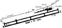
| Runways: | 06/24 |
| Longest Runway: | 06/24 is 6610 ft (2015 m) long |
| Runways with an Instrument Approach: |
KAOC Airport Runway Details
| Runway 06/24 | 6610 ft x 75 ft (2015 m x 23 m) | |
| Runway Length Source: | 3RD PARTY SURVEY as of 11/08/2011 | |
| Surface: | Asphalt - Fair condition - No special surface treatment | |
| Runway Edge Lights: | Medium Intensity | |
Runway Weight Bearing Capacity (in thousands of pounds) |
||
| Single Wheel Landing Gear: | 300.0 | |
Runway 06 |
Runway 24 |
|
Elevation: |
5335.3 | 5327.9 |
Latitude: |
43-36-01.6594N | 43-36-23.8182N |
Longitude: |
113-20-45.5436W | 113-19-21.0651W |
|
Runway True Alignment: |
070 | 250 |
Glide Path Angle: |
3.0 degrees | 3.0 degrees |
Traffic Pattern: |
Left | Left |
Runway Markings Type: |
Nonprecision Instrument | Nonprecision Instrument |
Runway Markings Condition: |
Fair | Fair |
Object at End: |
PLINE | |
Object Height: |
35 | |
Distance from End: |
1800 | |
Object Centerline Offset: |
0 ft. left and right of centerline | |
Visual Glide Slope Indicators: |
2-Light PAPI On Left Side Of Runway | 2-Light PAPI On Left Side Of Runway |
REIL: |
Yes | Yes |
Threshold Crossing Height: |
40 | 40 |
Services
Airframe Repair: |
Minor |
Powerplant Repair: |
Major |
Bulk Oxygen: |
High Pressure / Low Pressure |
Fuel Available: |
100LL, Jet A+ |
Landing Fees: |
Yes |
Parking: |
Hangars and tiedowns available |
Maps & Diagrams
KAOC Sectional
Flight Planning
at skyvector.com
at skyvector.com