Location
Latitude: |
37-10-00.0970N (37.166694) |
Longitude: |
099-46-30.4610W (-99.775128) |
Elevation: |
1951.0 feet MSL (595 m MSL) |
Magnetic Variation: |
4.6 E (as of April 2024 from WMM2020 model) |
Time Zone: |
UTC -6.0 (Standard Time) UTC -5.0 (Daylight Savings Time) |
From City: |
01 N.M. S of Ashland, Kansas |
Found On: |
Wichita Chart |
FAA Region: |
ACE |
Contacts
Manager: |
Publicly owned: |
| BRANDEN BATES BOX 547 ASHLAND, KS 67831 620-635-2531 |
CITY OF ASHLAND PO BOX 547 ASHLAND, KS 67831 620-635-2531 |
Operations
Airport Status: |
Operational |
Facility Use: |
Public |
Type: |
Airport |
Activation Date: |
12/1945 |
Control tower: |
No |
Attendance (Months/Days/Hours): |
Months/Days/Hours Unattended |
Boundary ARTCC: |
ZKC (Kansas City) |
Responsible ARTCC: |
ZKC (Kansas City) |
Segmented Circle Indicator: |
No |
Traffic Pattern Altitude (MSL): |
2951 feet (899 m) |
NOTAMs Facility: |
ICT |
NOTAM-D Service: |
Yes |
International Airport of Entry: |
No |
Customs Landing Rights: |
No |
Military Landing Rights: |
No |
Civil/Military Joint Use: |
No |
Based Aircraft
| Single Engine: | 5 |
Annual Operations (as of 08/05/2019)
| Total Operations: | 2500 | |
| GA Local: | 2000 | 80.0% |
| GA Itinerant: | 500 | 20.0% |
Communications
| CTAF: | 122.900 |
Fixed Based Operators (FBOs) & Fuel
(Click on a business for detail)
Please help us keep this information up to date. This is a FREE SERVICE just like everything else on Airport Guide! If you see that a business needs to be added, modified, or deleted please fill out our Update Form.
To add, modify, or delete a business click here.
Please help us keep this information up to date. This is a FREE SERVICE just like everything else on Airport Guide! If you see that a business needs to be added, modified, or deleted please fill out our Update Form.
Area Code: 620 |
| Business Name | Frequency | Phone | Fuel Grade |
|---|
Flight Service Stations
| Primary | Alternate | |
| FSS on Field: | N | |
| FSS Name (ID): | Wichita(ICT) | |
| Frequency: | ||
| Toll Free Phone: | 1-800-WX-BRIEF |
Instrument Procedures / Charts
Terminal Procedures are only available for airports in several countries with more being added all the time. If you are looking for a specific country's charts, please send an email to support(at)airportguide.com stating the country name. This will be used to prioritize the implementation.
Navigation Aids (Navaids) near K58
| Dist (NM) | ID | Morse Code | Name | Type | Freq | True Hdg | Mag Hdg |
|---|---|---|---|---|---|---|---|
| 19.6 | BFK | _ . . . . . _ . _ . _ | Buffalo | NDB | 215 | 157 | 152 |
| 42.5 | DDC | _ . . _ . . _ . _ . | Dodge City | VORTAC | 108.20 | 345 | 340 |
| 49.5 | MDF | _ _ _ . . . . _ . | Mooreland | NDB | 284 | 145 | 141 |
| 49.6 | MMB | _ _ _ _ _ . . . | Mitbee | VORTAC | 115.60 | 185 | 180 |
| 57.7 | LBL | . _ . . _ . . . . _ . . | Liberal | TACAN | 112.30 | 263 | 258 |
| 57.8 | LB | . _ . . _ . . . | Panck | NDB | 383 | 258 | 253 |
| 59.4 | PTT | . _ _ . _ _ | Pratt | NDB | 356 | 55 | 51 |
| 60.2 | GC | _ _ . _ . _ . | Pieve | NDB | 347 | 311 | 306 |
| 63.9 | GCK | _ _ . _ . _ . _ . _ | Garden City | VORTAC | 113.30 | 315 | 310 |
| 65.1 | PYX | . _ _ . _ . _ _ _ . . _ | Perryton | NDB | 266 | 226 | 221 |
| 70.3 | LQR | . _ . . _ _ . _ . _ . | Larned | NDB | 296 | 27 | 23 |
| 76.5 | HQG | . . . . _ _ . _ _ _ . | Hugoton | NDB | 365 | 270 | 265 |
| 76.7 | ANY | . _ _ . _ . _ _ | Anthony | TACAN | 112.90 | 89 | 85 |
| 78.4 | GB | _ _ . _ . . . | Babsy | NDB | 419 | 33 | 29 |
| 80.2 | ULS | . . _ . _ . . . . . | Ulysses | NDB | 395 | 289 | 284 |
| 82.6 | HIL | . . . . . . . _ . . | Hilyn | NDB | 338 | 29 | 25 |
| 87.5 | GUY | _ _ . . . _ _ . _ _ | Guymon | NDB | 275 | 252 | 247 |
| 94.8 | TQK | _ _ _ . _ _ . _ | Scott City | NDB | 256 | 326 | 321 |
| 97.5 | JHN | . _ _ _ . . . . _ . | Bear Creek | NDB | 341 | 287 | 282 |
| 99.3 | HY | . . . . _ . _ _ | Nette | NDB | 374 | 14 | 10 |
Nearby Airports with Fuel
Notices to Airmen (NOTAMS)
Remarks
| A110-1 | PUBLIC PHONE AVBL 24 HRS 620-635-2153. |
| A110-2 | FOR CD CTC KANSAS CITY ARTCC AT 913-254-8508. |
| A40-14/32 | NSTD LIRL; LGTS LCTD ON OUTER EDGE OF RWY. |
| A42-02 | MKD WITH ORANGE/WHITE PANELS AND ORANGE SKIRTS. |
| A42-14 | MKD WITH LGTS & PANELS. |
| A42-20 | MKD WITH ORANGE/WHITE PANELS AND ORANGE SKIRTS. |
| A42-32 | MKD WITH LGTS & PANELS. |
| A70-FUEL-10 | 0LL PPR FOR FUEL CALL (620) 635-2200. |
| E111 | ARPT CONSTRUCTED PRIOR TO 1959. |
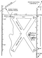
Runways
Runway Summary
| Runways: | 02/20 14/32 |
| Longest Runway: | 14/32 is 3135 ft (956 m) long |
| Runways with an Instrument Approach: |
K58 Airport Runway Details
| Runway 02/20 | 3125 ft x 300 ft (952 m x 91 m) | |
| Surface: | Turf - Fair condition - No special surface treatment | |
Runway 02 |
Runway 20 |
|
Glide Path Angle: |
0.0 degrees | 0.0 degrees |
Traffic Pattern: |
Left | Left |
Object at End: |
FENCE | ROAD |
Object Height: |
6 | 15 |
Distance from End: |
0 | 0 |
Object Centerline Offset: |
0 ft. left and right of centerline | 0 ft. left and right of centerline |
| Runway 14/32 | 3135 ft x 300 ft (956 m x 91 m) | |
| Surface: | Turf - Fair condition - No special surface treatment | |
| Runway Edge Lights: | Non-standard lighting system Intensity | |
Runway 14 |
Runway 32 |
|
Glide Path Angle: |
0.0 degrees | 0.0 degrees |
Traffic Pattern: |
Right | Left |
Object at End: |
FENCE | ROAD |
Object Height: |
4 | 15 |
Distance from End: |
129 | 110 |
Object Centerline Offset: |
0 ft. left and right of centerline | 0 ft. left and right of centerline |
Services
Airframe Repair: |
Major |
Powerplant Repair: |
Major |
Bottled Oxygen: |
None |
Bulk Oxygen: |
High Pressure / Low Pressure |
Fuel Available: |
100LL, Jet A |
Landing Fees: |
No |
Parking: |
Hangars and tiedowns available |
Maps & Diagrams
K58 Sectional
Flight Planning
at skyvector.com
at skyvector.com