Location
Latitude: |
37-33-55.4000N (37.565389) |
Longitude: |
097-10-28.6000W (-97.174611) |
Elevation: |
1343.9 feet MSL (410 m MSL) |
Magnetic Variation: |
3 E (as of April 2024 from WMM2020 model) |
Time Zone: |
UTC -6.0 (Standard Time) UTC -5.0 (Daylight Savings Time) |
From City: |
02 N.M. W of Rose Hill, Kansas |
Found On: |
Wichita Chart |
FAA Region: |
ACE |
Contacts
Manager: |
Privately owned: |
| STEVE LOGUE 6841 S.143RD DERBY, KS 67037 316-706-6131 |
CROSSWIND AVAITION INC. P.O. BOX 574 ROSE HILL, KS 67133 316-706-6131 |
Operations
Airport Status: |
Operational |
Facility Use: |
Public |
Type: |
Airport |
Activation Date: |
03/1960 |
Control tower: |
No |
Attendance (Months/Days/Hours): |
Months/Days/Hours Unattended |
Boundary ARTCC: |
ZKC (Kansas City) |
Responsible ARTCC: |
ZKC (Kansas City) |
Lighting Schedule: |
SEE RMK |
Segmented Circle Indicator: |
No |
Traffic Pattern Altitude (MSL): |
2344 feet (714 m) |
NOTAMs Facility: |
ICT |
NOTAM-D Service: |
Yes |
International Airport of Entry: |
No |
Customs Landing Rights: |
No |
Military Landing Rights: |
No |
Civil/Military Joint Use: |
No |
Based Aircraft
| Single Engine: | 77 |
| Multi Engine: | 3 |
| Ultralights: | 2 |
Annual Operations (as of 07/19/2019)
| Total Operations: | 18760 | |
| GA Local: | 17820 | 95.0% |
| GA Itinerant: | 940 | 5.0% |
Communications
| CTAF: | 122.800 |
| Unicom: | 122.800 |
Fixed Based Operators (FBOs) & Fuel
(Click on a business for detail)
Please help us keep this information up to date. This is a FREE SERVICE just like everything else on Airport Guide! If you see that a business needs to be added, modified, or deleted please fill out our Update Form.
To add, modify, or delete a business click here.
Please help us keep this information up to date. This is a FREE SERVICE just like everything else on Airport Guide! If you see that a business needs to be added, modified, or deleted please fill out our Update Form.
| Business Name | Frequency | Phone | Fuel Grade |
|---|
Flight Service Stations
| Primary | Alternate | |
| FSS on Field: | N | |
| FSS Name (ID): | Wichita(ICT) | |
| Frequency: | ||
| Toll Free Phone: | 1-800-WX-BRIEF |
Instrument Procedures / Charts
Terminal Procedures are only available for airports in several countries with more being added all the time. If you are looking for a specific country's charts, please send an email to support(at)airportguide.com stating the country name. This will be used to prioritize the implementation.
Navigation Aids (Navaids) near K50
| Dist (NM) | ID | Morse Code | Name | Type | Freq | True Hdg | Mag Hdg |
|---|---|---|---|---|---|---|---|
| 5.6 | IAB | . . . _ _ . . . | Mc Connell | TACAN | 116.50 | 307 | 304 |
| 13.0 | ICT | . . _ . _ . _ | Wichita | VOT | 114.00 | 289 | 286 |
| 13.4 | IC | . . _ . _ . | Piche | NDB | 332 | 273 | 270 |
| 17.8 | EGT | . _ _ . _ | Wellington | NDB | 414 | 215 | 212 |
| 22.2 | ICT | . . _ . _ . _ | Wichita | VORTAC | 113.80 | 299 | 296 |
| 29.3 | SO | . . . _ _ _ | Sawcy | NDB | 353 | 166 | 163 |
| 30.3 | EWK | . . _ _ _ . _ | Newton | NDB | 281 | 351 | 348 |
| 35.1 | CA | _ . _ . . _ | Harvs | NDB | 395 | 352 | 349 |
| 44.4 | HUT | . . . . . . _ _ | Hutchinson | VOR-DME | 116.80 | 305 | 302 |
| 44.6 | PN | . _ _ . _ . | Ponca | NDB | 515 | 175 | 172 |
| 48.9 | HU | . . . . . . _ | Saltt | NDB | 404 | 313 | 310 |
| 49.1 | PER | . _ _ . . . _ . | Pioneer | VORTAC | 113.20 | 179 | 176 |
| 52.9 | MPR | _ _ . _ _ . . _ . | Mc Pherson | NDB | 227 | 332 | 329 |
| 53.4 | ANY | . _ _ . _ . _ _ | Anthony | TACAN | 112.90 | 243 | 240 |
| 65.6 | EMP | . _ _ . _ _ . | Emporia | VORTAC | 112.80 | 48 | 45 |
| 68.4 | LYO | . _ . . _ . _ _ _ _ _ | Lyons | NDB | 386 | 313 | 310 |
| 69.8 | HRU | . . . . . _ . . . _ | Herington | NDB | 407 | 14 | 11 |
| 70.5 | BV | _ . . . . . . _ | Dewie | NDB | 201 | 127 | 124 |
| 70.6 | BVO | _ . . . . . . _ _ _ _ | Bartlesville | VOR-DME | 117.90 | 128 | 125 |
| 70.6 | SL | . . . . _ . . | Flory | NDB | 344 | 341 | 338 |
Nearby Airports with Fuel
Notices to Airmen (NOTAMS)
Remarks
| A110-1 | FOR CD CTC WICHITA APCH AT 316-350-1520. |
| A110-3 | RWY 17 CLNC SLOPE 21:1 TO 190 FT DSPLCD THLD. |
| A14 | CO-MANAGER GREG THOMAS |
| A16 | CO-MANAGER PHONE 316-650-6581. |
| A42-19 | MKD WITH ORANGE CONES. |
| A58-17 | 12 FT TREE 120 FT FM THLD 55 FT RIGHT OF CNTRLN AND 6 FT TREE 180 FT FM THLD 80 FT LEFT OF CNTRLN. |
| A70-FUEL-10 | 0LL SELF-SVC FUEL AVBL 24 HRS. |
| A80 | ACTVT BCN - 123.5. |
| A81-APT | ACTVT PAPI RWY 17; MIRL RWY 17/35 - 123.5. |
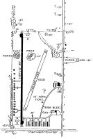
Runways
Runway Summary
| Runways: | 01/19 17/35 |
| Longest Runway: | 17/35 is 3472 ft (1058 m) long |
| Runways with an Instrument Approach: |
K50 Airport Runway Details
| Runway 01/19 | 1600 ft x 50 ft (488 m x 15 m) | |
| Runway Length Source: | 3RD PARTY SURVEY as of 08/07/2020 | |
| Surface: | Turf - Good condition - No special surface treatment | |
Runway 01 |
Runway 19 |
|
Elevation: |
1341.5 | 1329.9 |
Latitude: |
37-33-48.4978N | 37-34-03.6227N |
Longitude: |
097-10-29.1108W | 097-10-23.2934W |
Glide Path Angle: |
0.0 degrees | 0.0 degrees |
Traffic Pattern: |
Left | Left |
Object at End: |
ROAD | TREE |
Object Height: |
15 | 63 |
Distance from End: |
230 | 655 |
Object Centerline Offset: |
0 ft. left and right of centerline | 0 ft. left and right of centerline |
| Runway 17/35 | 3472 ft x 40 ft (1058 m x 12 m) | |
| Runway Length Source: | FAA OE/AAA as of 08/07/2020 | |
| Surface: | Turf - Good condition - No special surface treatment | |
| Runway Edge Lights: | Medium Intensity | |
Runway Weight Bearing Capacity (in thousands of pounds) |
||
| Single Wheel Landing Gear: | 2.0 | |
Runway 17 |
Runway 35 |
|
Elevation: |
1335.7 | 1336.4 |
Latitude: |
37-34-12.2334N | 37-33-37.9187N |
Longitude: |
097-10-29.8377W | 097-10-29.7176W |
Glide Path Angle: |
3.5 degrees | 3.0 degrees |
Traffic Pattern: |
Left | Right |
Runway Markings Type: |
Basic | Basic |
Runway Markings Condition: |
Good | Good |
Object at End: |
TREES | ROAD |
Object Height: |
24 | 15 |
Distance from End: |
330 | 400 |
Object Centerline Offset: |
0 ft. left and right of centerline | 0 ft. left and right of centerline |
Visual Glide Slope Indicators: |
2-Light PAPI On Left Side Of Runway | 2-Light PAPI On Left Side Of Runway |
Threshold Crossing Height: |
24 | 17 |
Threshold Elevation: |
1336.1 | |
Displaced Threshold: |
198 | |
Threshold Latitude: |
37-34-10.2728N | |
Threshold Longitude: |
097-10-29.8308W |
Services
Airframe Repair: |
None |
Powerplant Repair: |
None |
Bottled Oxygen: |
None |
Bulk Oxygen: |
None |
Fuel Available: |
100LL |
Landing Fees: |
No |
Parking: |
Hangars and tiedowns available |
Maps & Diagrams
K50 Sectional
Flight Planning
at skyvector.com
at skyvector.com