Location
Latitude: |
39-41-29.7300N (39.691592) |
Longitude: |
082-11-52.0370W (-82.197788) |
Elevation: |
1051.7 feet MSL (321 m MSL) |
Magnetic Variation: |
7.7 W (as of April 2024 from WMM2020 model) |
Time Zone: |
UTC -5.0 (Standard Time) UTC -4.0 (Daylight Savings Time) |
From City: |
02 N.M. S of New Lexington, Ohio |
Found On: |
Cincinnati Chart |
FAA Region: |
AGL |
Contacts
Manager: |
Publicly owned: |
| LAWRENCE NASH 1870 AIRPORT RD NEW LEXINGTON, OH 43764-9681 740-605-1932 |
PERRY COUNTY ARPT AUTH COURTHOUSE, 105 N MAIN ST NEW LEXINGTON, OH 43764-1262 330-687-2160 |
Operations
Airport Status: |
Operational |
Facility Use: |
Public |
Type: |
Airport |
Control tower: |
No |
Attendance (Months/Days/Hours): |
Months/Days/Hours Unattended |
Boundary ARTCC: |
ZID (Indianapolis) |
Responsible ARTCC: |
ZID (Indianapolis) |
Lighting Schedule: |
SEE RMK |
Segmented Circle Indicator: |
No |
Traffic Pattern Altitude (MSL): |
2052 feet (625 m) |
NOTAMs Facility: |
CLE |
NOTAM-D Service: |
Yes |
International Airport of Entry: |
No |
Customs Landing Rights: |
No |
Military Landing Rights: |
No |
Civil/Military Joint Use: |
No |
Based Aircraft
| Single Engine: | 10 |
Annual Operations (as of 08/04/2022)
| Total Operations: | 4550 | |
| GA Local: | 4000 | 87.9% |
| GA Itinerant: | 500 | 11.0% |
| Military Aircraft: | 50 | 1.1% |
Communications
| CTAF: | 122.800 |
| Unicom: | 122.800 |
- APCH/DEP SVC PRVDD BY INDIANAPOLIS ARTCC ON FREQS 124.45/323.275 (ZANESVILLE RCAG).
Fixed Based Operators (FBOs) & Fuel
(Click on a business for detail)
Please help us keep this information up to date. This is a FREE SERVICE just like everything else on Airport Guide! If you see that a business needs to be added, modified, or deleted please fill out our Update Form.
To add, modify, or delete a business click here.
Please help us keep this information up to date. This is a FREE SERVICE just like everything else on Airport Guide! If you see that a business needs to be added, modified, or deleted please fill out our Update Form.
Area Code: 740 |
| Business Name | Frequency | Phone | Fuel Grade |
|---|
Flight Service Stations
| Primary | Alternate | |
| FSS on Field: | N | |
| FSS Name (ID): | Cleveland(CLE) | |
| Frequency: | ||
| Toll Free Phone: | 1-800-WX-BRIEF |
Instrument Procedures / Charts
FAA Terminal Procedures valid from 0901Z 03/21/24 to 0901Z 04/18/24.
There are various types of charts available for an airport. They are listed in the Page Type column. Here is a legend for those types:
APD - Airport Diagram
DP - Departure Procedure Charts
HOT - Hot Spots
IAP - Instrument Approach Procedure Charts
MIN - Minimums
STAR - Standard Terminal Arrival Charts
| Page Type | Page Name | Volume | Action Since Last Cycle |
|---|---|---|---|
| IAP | RNAV (GPS) RWY 26 | EC-2 | |
| IAP | VOR/DME RWY 26 | EC-2 | |
| MIN | TAKEOFF MINIMUMS | EC-2 |
Terminal Procedures are only available for airports in several countries with more being added all the time. If you are looking for a specific country's charts, please send an email to support(at)airportguide.com stating the country name. This will be used to prioritize the implementation.
Navigation Aids (Navaids) near I86
| Dist (NM) | ID | Morse Code | Name | Type | Freq | True Hdg | Mag Hdg |
|---|---|---|---|---|---|---|---|
| 18.2 | HRA | . . . . . _ . . _ | Zanesville | NDB | 204 | 44 | 52 |
| 20.5 | ZZV | _ _ . . _ _ . . . . . _ | Zanesville | VOR-DME | 114.95 | 43 | 51 |
| 23.5 | HEH | . . . . . . . . . | Newark | NDB | 524 | 328 | 336 |
| 26.3 | UGS | . . _ _ _ . . . . | University | NDB | 250 | 172 | 180 |
| 27.9 | UNI | . . _ _ . . . | Athens | FAN MARKER | 179 | 187 | |
| 31.1 | CM | _ . _ . _ _ | Sumie | NDB | 391 | 304 | 312 |
| 31.5 | LC | . _ . . _ . _ . | Pickl | NDB | 376 | 291 | 299 |
| 32.9 | APE | . _ . _ _ . . | Appleton | VORTAC | 116.70 | 327 | 335 |
| 34.4 | LCK | . _ . . _ . _ . _ . _ | Rickenbacker | TACAN | 69X | 281 | 289 |
| 36.5 | CMH | _ . _ . _ _ . . . . | Port Columbus | VOT | 111.00 | 300 | 308 |
| 37.4 | XUB | _ . . _ . . _ _ . . . | Yellow Bud | VOR | 112.50 | 254 | 261 |
| 38.1 | DD | _ . . _ . . | Cobbs | NDB | 253 | 274 | 281 |
| 40.6 | PKB | . _ _ . _ . _ _ . . . | Marietta Ohio | FAN MARKER | 116 | 124 | |
| 40.9 | JPU | . _ _ _ . _ _ . . . _ | Parkersburg | VOR-DME | 114.45 | 111 | 119 |
| 41.3 | RZT | . _ . _ _ . . _ | Ross County | NDB | 236 | 248 | 255 |
| 42.2 | PK | . _ _ . _ . _ | Versi | NDB | 388 | 128 | 136 |
| 42.8 | CHC | _ . _ . . . . . _ . _ . | Grens | NDB | 272 | 296 | 303 |
| 46.3 | CTW | _ . _ . _ . _ _ | Newcomerstown | DME | 111.8 | 45 | 53 |
| 46.3 | EOP | . _ _ _ . _ _ . | Waverly | NDB | 385 | 227 | 234 |
| 47.1 | BU | _ . . . . . _ | Boutn | NDB | 230 | 279 | 286 |
Nearby Airports with Fuel
Notices to Airmen (NOTAMS)
Remarks
| A110-1 | DEER & TURKEYS ON & INVOF ARPT. |
| A110-4 | FOR CD CTC COLUMBUS APCH AT 614-338-8537. |
| A42-08 | FADED. |
| A42-26 | FADED. |
| A58-08 | +2-12 FT BRUSH, 0-125 FT DIST, 20 FT R. |
| A58-26 | +8 FT FENCE, 0-124 FT DIST, 120-140 FT R. |
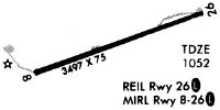
| A81-APT | ACTVT REIL RWY 26; MIRL RWY 08/26 - CTAF. |
Runways
Runway Summary
| Runways: | 08/26 |
| Longest Runway: | 08/26 is 3498 ft (1066 m) long |
| Runways with an Instrument Approach: |
I86 Airport Runway Details
| Runway 08/26 | 3498 ft x 75 ft (1066 m x 23 m) | |
| Runway Length Source: | 3RD PARTY SURVEY as of 11/14/2022 | |
| Surface: | Asphalt - Good condition - No special surface treatment | |
| Runway Edge Lights: | Medium Intensity | |
Runway 08 |
Runway 26 |
|
Elevation: |
1051.7 | 1041.8 |
Latitude: |
39-41-24.4314N | 39-41-35.0268N |
Longitude: |
082-12-13.3303W | 082-11-30.7434W |
|
Runway True Alignment: |
072 | 252 |
Glide Path Angle: |
3.5 degrees | 4.0 degrees |
Traffic Pattern: |
Left | Left |
Runway Markings Type: |
Nonprecision Instrument | Nonprecision Instrument |
Runway Markings Condition: |
Fair | Fair |
Object at End: |
BRUSH | TREES |
Object Height: |
10 | 30 |
Distance from End: |
260 | 201 |
Object Centerline Offset: |
43 ft. right of centerline | 170 ft. right of centerline |
Visual Glide Slope Indicators: |
2-Light PAPI On Right Side Of Runway | 2-Light PAPI On Left Side Of Runway |
REIL: |
No | Yes |
Touchdown Lights: |
No | No |
Centerline Lights: |
No | No |
Threshold Crossing Height: |
24 | 28 |
Services
Bottled Oxygen: |
None |
Bulk Oxygen: |
None |
Fuel Available: |
100LL |
Landing Fees: |
No |
Maps & Diagrams
I86 Sectional
Flight Planning
at skyvector.com
at skyvector.com