Location
Latitude: |
39-39-15.2450N (39.654235) |
Longitude: |
081-48-11.4750W (-81.803188) |
Elevation: |
1000.0 feet MSL (305 m MSL) |
Magnetic Variation: |
8 W (as of April 2024 from WMM2020 model) |
Time Zone: |
UTC -5.0 (Standard Time) UTC -4.0 (Daylight Savings Time) |
From City: |
03 N.M. E of Mc Connelsville, Ohio |
Found On: |
Cincinnati Chart |
FAA Region: |
AGL |
Contacts
Manager: |
Publicly owned: |
| KURT JOHNSON 995 E AIRPORT RD NE MCCONNELLSVILLE, OH 43756-9323 334-447-0624 |
MORGAN COUNTY AIRPORT AUTH 995 E AIRPORT RD NE MCCONNELSVILLE, OH 43756-9323 334-447-0624 |
Operations
Airport Status: |
Operational |
Facility Use: |
Public |
Type: |
Airport |
Activation Date: |
08/1967 |
Control tower: |
No |
Attendance (Months/Days/Hours): |
Months/Days/Hours Unattended |
Boundary ARTCC: |
ZID (Indianapolis) |
Responsible ARTCC: |
ZID (Indianapolis) |
Lighting Schedule: |
SEE RMK |
Segmented Circle Indicator: |
No |
Traffic Pattern Altitude (MSL): |
2000 feet (610 m) |
NOTAMs Facility: |
CLE |
NOTAM-D Service: |
Yes |
International Airport of Entry: |
No |
Customs Landing Rights: |
No |
Military Landing Rights: |
No |
Civil/Military Joint Use: |
No |
Based Aircraft
| Single Engine: | 6 |
| GA Helicopters: | 1 |
Annual Operations (as of 07/02/2021)
| Total Operations: | 175 | |
| GA Local: | 100 | 57.1% |
| GA Itinerant: | 50 | 28.6% |
| Military Aircraft: | 25 | 14.3% |
Communications
| CTAF: | 122.800 |
| Unicom: | 122.800 |
Fixed Based Operators (FBOs) & Fuel
(Click on a business for detail)
Please help us keep this information up to date. This is a FREE SERVICE just like everything else on Airport Guide! If you see that a business needs to be added, modified, or deleted please fill out our Update Form.
To add, modify, or delete a business click here.
Please help us keep this information up to date. This is a FREE SERVICE just like everything else on Airport Guide! If you see that a business needs to be added, modified, or deleted please fill out our Update Form.
Area Code: 740 |
| Business Name | Frequency | Phone | Fuel Grade |
|---|
Flight Service Stations
| Primary | Alternate | |
| FSS on Field: | N | |
| FSS Name (ID): | Cleveland(CLE) | |
| Frequency: | ||
| Toll Free Phone: | 1-800-WX-BRIEF |
Instrument Procedures / Charts
Terminal Procedures are only available for airports in several countries with more being added all the time. If you are looking for a specific country's charts, please send an email to support(at)airportguide.com stating the country name. This will be used to prioritize the implementation.
Navigation Aids (Navaids) near I71
| Dist (NM) | ID | Morse Code | Name | Type | Freq | True Hdg | Mag Hdg |
|---|---|---|---|---|---|---|---|
| 16.0 | HRA | . . . . . _ . . _ | Zanesville | NDB | 204 | 340 | 348 |
| 17.7 | ZZV | _ _ . . _ _ . . . . . _ | Zanesville | VOR-DME | 114.95 | 346 | 354 |
| 23.6 | JPU | . _ _ _ . _ _ . . . _ | Parkersburg | VOR-DME | 114.45 | 122 | 130 |
| 24.2 | PKB | . _ _ . _ . _ _ . . . | Marietta Ohio | FAN MARKER | 131 | 139 | |
| 28.1 | UGS | . . _ _ _ . . . . | University | NDB | 250 | 212 | 220 |
| 28.2 | PK | . _ _ . _ . _ | Versi | NDB | 388 | 148 | 156 |
| 31.5 | UNI | . . _ _ . . . | Athens | FAN MARKER | 215 | 223 | |
| 37.6 | CTW | _ . _ . _ . _ _ | Newcomerstown | DME | 111.8 | 23 | 31 |
| 37.7 | HEH | . . . . . . . . . | Newark | NDB | 524 | 306 | 314 |
| 46.8 | APE | . _ . _ _ . . | Appleton | VORTAC | 116.70 | 309 | 317 |
| 48.1 | CM | _ . _ . _ _ | Sumie | NDB | 391 | 294 | 302 |
| 49.5 | LC | . _ . . _ . _ . | Pickl | NDB | 376 | 286 | 294 |
| 50.4 | AIR | . _ . . . _ . | Bellaire | VOR-DME | 117.10 | 64 | 72 |
| 50.4 | CFX | _ . _ . . . _ . _ . . _ | Cadiz | NDB | 239 | 45 | 53 |
| 52.8 | LCK | . _ . . _ . _ . _ . _ | Rickenbacker | TACAN | 69X | 280 | 288 |
| 53.3 | MLR | _ _ . _ . . . _ . | Millersburg/Dcmsnd | NDB | 382 | 356 | 364 |
| 53.9 | CMH | _ . _ . _ _ . . . . | Port Columbus | VOT | 111.00 | 292 | 300 |
| 54.8 | XUB | _ . . _ . . _ _ . . . | Yellow Bud | VOR | 112.50 | 262 | 270 |
| 55.0 | HNN | . . . . _ . _ . | Henderson | DME | 115.9 | 190 | 198 |
| 56.4 | DD | _ . . _ . . | Cobbs | NDB | 253 | 275 | 283 |
Nearby Airports with Fuel
Notices to Airmen (NOTAMS)
Remarks
| A110-1 | DEER ON & INVOF ARPT. |
| A110-2 | FOR CD CTC INDIANAPOLIS ARTCC AT 317-247-2411. |
| A16 | EMERG TEL 740-962-3333-SHERIFF OFC. |
| A42-12 | FADED. |
| A42-30 | FADED. |
| A57-12 | APCH SLP 19:1 TO DTHR DUE TO 10 FT PVT ROAD, 0 FT DIST, 58 FT R; APCH SLP 0:1 DUE TO 20 FT HILL, 0 FT DIST, 96 FT L. |
| A58-12 | +12 FT TRRN, 0 FT DIST, 125 FT L. |
| A58-30 | +7 FT TRRN, 0 FT DIST, 125 FT R. |
| A70-FUEL-10 | 0LL FOR FUEL REFER TO LIST IN ADMIN BLDG. |
| A75 | PRIOR CDN RQRD. |
| A75 1 | NO TIE DOWN ROPES. |
| A81-APT | ACTVT MIRL RWY 12/30 - CTAF. |
| E111 | VFR ONLY. |
Runways
Runway Summary
| Runways: | 12/30 |
| Longest Runway: | 12/30 is 3500 ft (1067 m) long |
| Runways with an Instrument Approach: |
I71 Airport Runway Details
| Runway 12/30 | 3500 ft x 65 ft (1067 m x 20 m) | |
| Surface: | Asphalt - Fair condition - No special surface treatment | |
| Runway Edge Lights: | Medium Intensity | |
Runway Weight Bearing Capacity (in thousands of pounds) |
||
| Single Wheel Landing Gear: | 12.0 | |
Runway 12 |
Runway 30 |
|
Elevation: |
1000.0 | 1000.0 |
Latitude: |
39-39-23.5000N | 39-39-06.9900N |
Longitude: |
081-48-31.1400W | 081-47-51.8100W |
|
Runway True Alignment: |
119 | 299 |
Glide Path Angle: |
0.0 degrees | 0.0 degrees |
Traffic Pattern: |
Left | Left |
Runway Markings Type: |
Basic | Basic |
Runway Markings Condition: |
Poor | Poor |
Object at End: |
ROAD | HILL |
Object Height: |
25 | 6 |
Object Marked/Lighted?: |
Lighted | |
Distance from End: |
225 | 250 |
Object Centerline Offset: |
125 ft. left of centerline | 125 ft. right of centerline |
REIL: |
No | No |
Touchdown Lights: |
No | No |
Centerline Lights: |
No | No |
Displaced Threshold: |
350 | |
Threshold Latitude: |
39-39-21.8494N | |
Threshold Longitude: |
081-48-27.2073W |
Services
Airframe Repair: |
Major |
Powerplant Repair: |
Major |
Bottled Oxygen: |
High Pressure |
Bulk Oxygen: |
None |
Fuel Available: |
100LL, Jet A+ |
Landing Fees: |
No |
Parking: |
Hangars and tiedowns available |
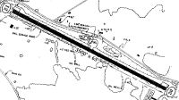
Maps & Diagrams
I71 Sectional
Flight Planning
at skyvector.com
at skyvector.com