Location
Latitude: |
40-18-36.6000N (40.310167) |
Longitude: |
081-51-08.7000W (-81.852417) |
Elevation: |
978.9 feet MSL (298 m MSL) |
Magnetic Variation: |
8 W (as of April 2024 from WMM2020 model) |
Time Zone: |
UTC -5.0 (Standard Time) UTC -4.0 (Daylight Savings Time) |
From City: |
03 N.M. N of Coshocton, Ohio |
Found On: |
Detroit Chart |
FAA Region: |
AGL |
Contacts
Manager: |
Publicly owned: |
| MARTY DOBSON 24569 AIRPORT RD COSHOCTON, OH 43812-9219 740-622-2252 |
COSHOCTON CO RGNL ARPT AUTH 24569 AIRPORT RD COSHOCTON, OH 43812-9219 740-622-2252 |
Operations
Airport Status: |
Operational |
Facility Use: |
Public |
Type: |
Airport |
Control tower: |
No |
Attendance (Months/Days/Hours): |
Months/Days/Hours ALL/ALL/0900-1700 |
Boundary ARTCC: |
ZID (Indianapolis) |
Responsible ARTCC: |
ZID (Indianapolis) |
Lighting Schedule: |
SEE RMK |
Segmented Circle Indicator: |
No |
Traffic Pattern Altitude (MSL): |
1979 feet (603 m) |
NOTAMs Facility: |
CLE |
NOTAM-D Service: |
Yes |
International Airport of Entry: |
No |
Customs Landing Rights: |
No |
Military Landing Rights: |
Yes |
Civil/Military Joint Use: |
No |
Based Aircraft
| Single Engine: | 16 |
| Multi Engine: | 3 |
Annual Operations (as of 05/31/2023)
| Total Operations: | 21800 | |
| Air Taxi: | 2500 | 11.5% |
| GA Local: | 15000 | 68.8% |
| GA Itinerant: | 4200 | 19.3% |
| Military Aircraft: | 100 | 0.5% |
Communications
| CTAF: | 123.000 |
| Unicom: | 123.000 |
| AWOS-3: | 118.875 (740-295-7370) |
- APCH/DEP SVC PRVDD BY INDIANAPOLIS ARTCC ON FREQS 124.45/323.275 (ZANESVILLE RCAG).
Fixed Based Operators (FBOs) & Fuel
(Click on a business for detail)
Please help us keep this information up to date. This is a FREE SERVICE just like everything else on Airport Guide! If you see that a business needs to be added, modified, or deleted please fill out our Update Form.
To add, modify, or delete a business click here.
Please help us keep this information up to date. This is a FREE SERVICE just like everything else on Airport Guide! If you see that a business needs to be added, modified, or deleted please fill out our Update Form.
Area Code: 614 |
| Business Name | Frequency | Phone | Fuel Grade |
|---|---|---|---|
| Coshocton County Airport
Update FBO info |
622-2252 | 80, 100LL, Jet A | |
| Flyway, Inc.
Update FBO info |
498-7265 |
Flight Service Stations
| Primary | Alternate | |
| FSS on Field: | N | |
| FSS Name (ID): | Cleveland(CLE) | |
| Frequency: | ||
| Toll Free Phone: | 1-800-WX-BRIEF |
Instrument Procedures / Charts
FAA Terminal Procedures valid from 0901Z 03/21/24 to 0901Z 04/18/24.
There are various types of charts available for an airport. They are listed in the Page Type column. Here is a legend for those types:
APD - Airport Diagram
DP - Departure Procedure Charts
HOT - Hot Spots
IAP - Instrument Approach Procedure Charts
MIN - Minimums
STAR - Standard Terminal Arrival Charts
| Page Type | Page Name | Volume | Action Since Last Cycle |
|---|---|---|---|
| IAP | RNAV (GPS) RWY 04 | EC-2 | |
| IAP | RNAV (GPS) RWY 22 | EC-2 | |
| MIN | TAKEOFF MINIMUMS | EC-2 |
Terminal Procedures are only available for airports in several countries with more being added all the time. If you are looking for a specific country's charts, please send an email to support(at)airportguide.com stating the country name. This will be used to prioritize the implementation.
Navigation Aids (Navaids) near I40
| Dist (NM) | ID | Morse Code | Name | Type | Freq | True Hdg | Mag Hdg |
|---|---|---|---|---|---|---|---|
| 13.9 | MLR | _ _ . _ . . . _ . | Millersburg/Dcmsnd | NDB | 382 | 356 | 364 |
| 17.9 | CTW | _ . _ . _ . _ _ | Newcomerstown | DME | 111.8 | 105 | 113 |
| 22.2 | ZZV | _ _ . . _ _ . . . . . _ | Zanesville | VOR-DME | 114.95 | 184 | 192 |
| 24.4 | HRA | . . . . . _ . . _ | Zanesville | NDB | 204 | 187 | 195 |
| 32.2 | BSV | _ . . . . . . . . . _ | Briggs | VOR-DME | 112.40 | 36 | 44 |
| 32.8 | HEH | . . . . . . . . . | Newark | NDB | 524 | 238 | 246 |
| 35.0 | APE | . _ . _ _ . . | Appleton | VORTAC | 116.70 | 254 | 262 |
| 38.5 | MF | _ _ . . _ . | Manns | NDB | 372 | 315 | 323 |
| 38.7 | CFX | _ . _ . . . _ . _ . . _ | Cadiz | NDB | 239 | 96 | 104 |
| 40.9 | CAK | _ . _ . . _ _ . _ | Akron/Canton Regional | VOT | 110.60 | 27 | 35 |
| 43.2 | AAU | . _ . _ . . _ | Ashland | NDB | 329 | 335 | 343 |
| 45.7 | CM | _ . _ . _ _ | Sumie | NDB | 391 | 245 | 253 |
| 47.5 | MFD | _ _ . . _ . _ . . | Mansfield | VORTAC | 108.80 | 315 | 323 |
| 50.2 | AK | . _ _ . _ | Akron | NDB | 362 | 24 | 32 |
| 50.6 | AIR | . _ . . . _ . | Bellaire | VOR-DME | 117.10 | 109 | 117 |
| 51.0 | CMH | _ . _ . _ _ . . . . | Port Columbus | VOT | 111.00 | 248 | 256 |
| 52.0 | LC | . _ . . _ . _ . | Pickl | NDB | 376 | 240 | 248 |
| 56.3 | ACO | . _ _ . _ . _ _ _ | Akron | VOR-DME | 114.40 | 31 | 39 |
| 56.6 | JPU | . _ _ _ . _ _ . . . _ | Parkersburg | VOR-DME | 114.45 | 156 | 164 |
| 56.9 | CHC | _ . _ . . . . . _ . _ . | Grens | NDB | 272 | 251 | 259 |
Nearby Airports with Fuel
Notices to Airmen (NOTAMS)
Remarks
| A110-1 | DEER, BIRDS, & OTR WILDLIFE ON & INVOF ARPT. |
| A110-2 | GCO AVBL ON FREQ 121.725 INDIANAPOLIS CENTER. |
| A110-3 | FOR CD IF UNA VIA GCO CTC INDIANAPOLIS ARTCC AT 317-247-2411. |
| A17 | FOR SER AFT HRS SEE SIGN IN FBO VESTIBULE FOR CTC INFO. |
| A43-22 | UNUSBL BYD 8 DEGS L OF CRS. |
| A58-04 | +10 BRUSH, 0-150 FT DIST, 105 FT L. |
| A70-FUEL-10 | 0LL 100LL & JET A+ AVBL FULL SVC FM TRUCK. |
| A75 | ROPES NOT PRVDD. |
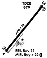
| A81-APT | ACTVT REIL RWY 22; MIRL RWY 04/22 - 122.9. PAPI RWY 04 & 22 OPR CONSLY. |
Runways
Runway Summary
| Runways: | 04/22 |
| Longest Runway: | 04/22 is 5001 ft (1524 m) long |
| Runways with an Instrument Approach: |
I40 Airport Runway Details
| Runway 04/22 | 5001 ft x 75 ft (1524 m x 23 m) | |
| Runway Length Source: | 3RD PARTY SURVEY as of 03/31/2011 | |
| Surface: | Asphalt - Good condition - No special surface treatment | |
| Runway Edge Lights: | Medium Intensity | |
Runway Weight Bearing Capacity (in thousands of pounds) |
||
| Single Wheel Landing Gear: | 30.0 | |
| Dual Wheel Landing Gear: | 35.0 | |
Runway 04 |
Runway 22 |
|
Elevation: |
973.1 | 978.6 |
Latitude: |
40-18-16.9438N | 40-18-56.2190N |
Longitude: |
081-51-28.2408W | 081-50-49.0650W |
|
Runway True Alignment: |
037 | 217 |
Glide Path Angle: |
3.5 degrees | 3.0 degrees |
Traffic Pattern: |
Left | Left |
Runway Markings Type: |
Nonprecision Instrument | Nonprecision Instrument |
Runway Markings Condition: |
Fair | Fair |
Object at End: |
TREES | |
Object Height: |
21 | |
Distance from End: |
378 | |
Object Centerline Offset: |
170 ft. left of centerline | |
Visual Glide Slope Indicators: |
2-Light PAPI On Left Side Of Runway | 4-Light PAPI On Right Side Of Runway |
REIL: |
No | Yes |
Touchdown Lights: |
No | No |
Centerline Lights: |
No | No |
Threshold Crossing Height: |
26 | 25 |
Services
Airframe Repair: |
None |
Powerplant Repair: |
None |
Bottled Oxygen: |
None |
Bulk Oxygen: |
None |
Fuel Available: |
100LL, Jet A+ |
Landing Fees: |
No |
Parking: |
Tiedowns available |
Maps & Diagrams
I40 Sectional
Flight Planning
at skyvector.com
at skyvector.com