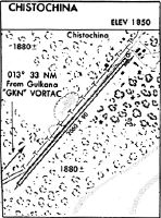
Location
Latitude: |
62-33-44.4000N (62.562333) |
Longitude: |
144-40-20.8000W (-144.672444) |
Elevation: |
1860.7 feet MSL (567 m MSL) |
Magnetic Variation: |
16.6 E (as of April 2024 from WMM2020 model) |
Time Zone: |
UTC -9.0 (Standard Time) UTC -8.0 (Daylight Savings Time) |
From City: |
00 N.M. SW of Chistochina, Alaska |
Found On: |
Anchorage Chart |
FAA Region: |
AAL |
Contacts
Manager: |
Publicly owned: |
| CHAD HELLER P O BOX 7 GLENALLEN, AK 99588 907-822-3222 |
ALASKA DOT&PF NORTHERN REGION 2301 PEGER RD FAIRBANKS, AK 99709-6900 907-451-2200 |
Operations
Airport Status: |
Operational |
Facility Use: |
Public |
Type: |
Airport |
Activation Date: |
11/1949 |
Control tower: |
No |
Attendance (Months/Days/Hours): |
Months/Days/Hours Unattended |
Boundary ARTCC: |
ZAN (Anchorage) |
Responsible ARTCC: |
ZAN (Anchorage) |
Segmented Circle Indicator: |
No |
Traffic Pattern Altitude (MSL): |
2861 feet (872 m) |
NOTAMs Facility: |
ENA |
NOTAM-D Service: |
Yes |
International Airport of Entry: |
No |
Customs Landing Rights: |
No |
Military Landing Rights: |
No |
Civil/Military Joint Use: |
No |
Based Aircraft
| Single Engine: | 1 |
Annual Operations (as of 12/31/2019)
| Total Operations: | 1600 | |
| Air Taxi: | 400 | 25.0% |
| GA Local: | 500 | 31.2% |
| GA Itinerant: | 700 | 43.8% |
Communications
| CTAF: | 122.900 |
Fixed Based Operators (FBOs) & Fuel
(Click on a business for detail)
Please help us keep this information up to date. This is a FREE SERVICE just like everything else on Airport Guide! If you see that a business needs to be added, modified, or deleted please fill out our Update Form.
To add, modify, or delete a business click here.
Please help us keep this information up to date. This is a FREE SERVICE just like everything else on Airport Guide! If you see that a business needs to be added, modified, or deleted please fill out our Update Form.
Area Code: 907 |
| Business Name | Frequency | Phone | Fuel Grade |
|---|
Flight Service Stations
| Primary | Alternate | |
| FSS on Field: | N | |
| FSS Name (ID): | Kenai(ENA) | |
| Frequency: | ||
| Toll Free Phone: | 1-866-864-1737 |
Instrument Procedures / Charts
Terminal Procedures are only available for airports in several countries with more being added all the time. If you are looking for a specific country's charts, please send an email to support(at)airportguide.com stating the country name. This will be used to prioritize the implementation.
Navigation Aids (Navaids) near CZO
| Dist (NM) | ID | Morse Code | Name | Type | Freq | True Hdg | Mag Hdg |
|---|---|---|---|---|---|---|---|
| 31.2 | GLA | _ _ . . _ . . . _ | Glennallen | NDB | 248 | 225 | 209 |
| 32.7 | GKN | _ _ . _ . _ _ . | Gulkana | VOR-DME | 115.60 | 221 | 205 |
| 79.2 | ORT | _ _ _ . _ . _ | Northway | VORTAC | 116.30 | 71 | 54 |
| 79.3 | AES | . _ . . . . | Nabesna | NDB | 390 | 71 | 54 |
| 91.0 | BIG | _ . . . . . _ _ . | Big Delta | VORTAC | 114.90 | 342 | 326 |
| 91.8 | DJN | _ . . . _ _ _ _ . | Delta Junction | NDB | 347 | 343 | 327 |
| 98.5 | MNL | _ _ _ . . _ . . | Mineral Creek | NDB | 524 | 209 | 193 |
Nearby Airports with Fuel
| Dist (NM) | Name (Airport IDs) | True Hdg | Mag Hdg | Fuel Grade |
|---|---|---|---|---|
| 65.7 | Tok Junction Airport (TKJ PFTO 6K8) |
44 | 27 | 100LL, Jet A |
| 79.1 | Northway Airport (ORT PAOR ORT) |
71 | 54 | 100LL, Jet A |
Notices to Airmen (NOTAMS)
Remarks
| A110-2 | RY INFREQUENTLY MAINTAINED & CONDITION NOT MONITORED; RECOMMEND VISUAL INSPECTION PRIOR TO LANDING. |
| A110-3 | HWY 1 PARALLELS WEST EDGE OF RY. |
| A110-7 | WX CAMERA AVBL ON INTERNET AT HTTPS://WEATHERCAMS.FAA.GOV |
| A33-02/20 | GRASS, FORBS, AND WILLOWS TO 36 INCHES. SOFT WHEN WET. |
| A42-02 | RY 02 & 20 THLDS MKD WITH REFLECTIVE ORANGE CONES. |
| A52-20 | POWERLINE CROSSES APCH 450 FT FM RY 20 THLD. |
Runways
Runway Summary
| Runways: | 02/20 |
| Longest Runway: | 02/20 is 2060 ft (628 m) long |
| Runways with an Instrument Approach: |
CZO Airport Runway Details
| Runway 02/20 | 2060 ft x 60 ft (628 m x 18 m) | |
| Runway Length Source: | 3RD PARTY SURVEY as of 07/10/2013 | |
| Surface: | Turf/Gravel - Fair condition - No special surface treatment | |
Runway 02 |
Runway 20 |
|
Elevation: |
1852.7 | 1860.7 |
Latitude: |
62-33-36.8048N | 62-33-52.0170N |
Longitude: |
144-40-35.3617W | 144-40-06.2959W |
Glide Path Angle: |
0.0 degrees | 0.0 degrees |
Traffic Pattern: |
Left | Left |
Object at End: |
TREES | TREE |
Object Height: |
60 | 65 |
Distance from End: |
0 | 255 |
Object Centerline Offset: |
90 ft. right of centerline | 31 ft. left of centerline |
Services
Fuel Available: |
100LL, Jet A |
Landing Fees: |
No |
Parking: |
Hangars available |
Maps & Diagrams
CZO Sectional
Flight Planning
at skyvector.com
at skyvector.com