Location
Latitude: |
44-46-40.0190N (44.777783) |
Longitude: |
089-39-57.2800W (-89.665911) |
Elevation: |
1277.2 feet MSL (389 m MSL) |
Magnetic Variation: |
2.9 W (as of April 2024 from WMM2020 model) |
Time Zone: |
UTC -6.0 (Standard Time) UTC -5.0 (Daylight Savings Time) |
From City: |
03 N.M. SE of Mosinee, Wisconsin |
Found On: |
Green Bay Chart |
FAA Region: |
AGL |
Contacts
Manager: |
Publicly owned: |
| BRIAN GREFE 100 CWA DR. SUITE 227 MOSINEE, WI 54455 715-693-2147 |
MARATHON AND PORTAGE CO 100 CWA DR. SUITE 227 MOSINEE, WI 54455 715-693-2147 |
Operations
Airport Status: |
Operational |
Facility Use: |
Public |
Type: |
Airport |
Activation Date: |
10/1969 |
Control tower: |
Yes |
Attendance (Months/Days/Hours): |
Months/Days/Hours ALL/ALL/ALL |
Boundary ARTCC: |
ZMP (Minneapolis) |
Responsible ARTCC: |
ZMP (Minneapolis) |
Lighting Schedule: |
SEE RMK |
Segmented Circle Indicator: |
No |
Traffic Pattern Altitude (MSL): |
2277 feet (694 m) |
NOTAMs Facility: |
CWA |
NOTAM-D Service: |
Yes |
International Airport of Entry: |
No |
Customs Landing Rights: |
No |
Military Landing Rights: |
Yes |
Civil/Military Joint Use: |
No |
Aircraft Rescue and Firefighting: |
Class I ARFF Index: B Air Carrier Service: Scheduled Certification Date: 05/1973 |
Based Aircraft
| Single Engine: | 17 |
| Multi Engine: | 3 |
| Jet Engine: | 5 |
| GA Helicopters: | 1 |
| Gliders: | 1 |
Annual Operations (as of 12/31/2022)
| Total Operations: | 13592 | |
| Commercial: | 53 | 0.4% |
| Air Taxi: | 7642 | 56.2% |
| GA Local: | 1956 | 14.4% |
| GA Itinerant: | 3872 | 28.5% |
| Military Aircraft: | 69 | 0.5% |
Communications
| CTAF: | 119.750 |
| Unicom: | 122.950 |
| Tower: | CWA 119.75 360.7 Hrs: 0600-2200 |
| Ground: | 121.9 360.7 |
| Approach: | MINNEAPOLIS ARTCC |
| Departure: | MINNEAPOLIS ARTCC |
| ATIS: | 127.45 Hrs: 24 |
| AWOS-3: | 127.45 (715-693-1116) |
- APCH/DEP SVC PRVDD BY MINNEAPOLIS ARTCC ON FREQS 124.4/317.7 (MOSINEE RCAG).
- ATCT OPERATED BY MIDWEST AIR INC.
Fixed Based Operators (FBOs) & Fuel
(Click on a business for detail)
Please help us keep this information up to date. This is a FREE SERVICE just like everything else on Airport Guide! If you see that a business needs to be added, modified, or deleted please fill out our Update Form.
To add, modify, or delete a business click here.
Please help us keep this information up to date. This is a FREE SERVICE just like everything else on Airport Guide! If you see that a business needs to be added, modified, or deleted please fill out our Update Form.
Area Code: 715 |
| Business Name | Frequency | Phone | Fuel Grade |
|---|---|---|---|
| Central Wisconsin Aviation, Inc.
Update FBO info |
Unicom 122.95 | 693-6111 | 100LL, Jet A |
Flight Service Stations
| Primary | Alternate | |
| FSS on Field: | N | |
| FSS Name (ID): | Green Bay(GRB) | |
| Frequency: | ||
| Toll Free Phone: | 1-800-WX-BRIEF |
Instrument Procedures / Charts
FAA Terminal Procedures valid from 0901Z 03/21/24 to 0901Z 04/18/24.
There are various types of charts available for an airport. They are listed in the Page Type column. Here is a legend for those types:
APD - Airport Diagram
DP - Departure Procedure Charts
HOT - Hot Spots
IAP - Instrument Approach Procedure Charts
MIN - Minimums
STAR - Standard Terminal Arrival Charts
| Page Type | Page Name | Volume | Action Since Last Cycle |
|---|---|---|---|
| APD | AIRPORT DIAGRAM | EC-3 | Changed |
| HOT | HOT SPOT | EC-3 | Deleted |
| IAP | ILS OR LOC RWY 08 | EC-3 | Changed |
| IAP | ILS OR LOC RWY 35 | EC-3 | Changed |
| IAP | RNAV (GPS) RWY 08 | EC-3 | Changed |
| IAP | RNAV (GPS) RWY 17 | EC-3 | Changed |
| IAP | RNAV (GPS) RWY 26 | EC-3 | Changed |
| IAP | RNAV (GPS) RWY 35 | EC-3 | Changed |
| MIN | ALTERNATE MINIMUMS | EC-3 | |
| MIN | TAKEOFF MINIMUMS | EC-3 |
Terminal Procedures are only available for airports in several countries with more being added all the time. If you are looking for a specific country's charts, please send an email to support(at)airportguide.com stating the country name. This will be used to prioritize the implementation.
Navigation Aids (Navaids) near CWA
| Dist (NM) | ID | Morse Code | Name | Type | Freq | True Hdg | Mag Hdg |
|---|---|---|---|---|---|---|---|
| 5.3 | AUW | . _ . . _ . _ _ | Wausau | VOR-DME | 111.60 | 39 | 42 |
| 6.1 | PH | . _ _ . . . . . | Bayye | NDB | 351 | 172 | 175 |
| 9.2 | FZK | . . _ . _ _ . . _ . _ | Wausau | NDB | 243 | 10 | 13 |
| 15.2 | STE | . . . _ . | Stevens Point | VORTAC | 110.60 | 157 | 160 |
| 23.8 | MFI | _ _ . . _ . . . | Marshfield | NDB | 391 | 250 | 253 |
| 24.2 | DU | _ . . . . _ | Calin | NDB | 266 | 238 | 241 |
| 25.3 | RRL | . _ . . _ . . _ . . | Merrill | NDB | 257 | 356 | 359 |
| 25.9 | ISW | . . . . . . _ _ | Wisconsin Rapids | NDB | 215 | 196 | 199 |
| 32.5 | EK | . _ . _ | Nepco | NDB | 326 | 197 | 200 |
| 32.7 | AIG | . _ . . _ _ . | Antigo | NDB | 347 | 45 | 48 |
| 33.6 | MDZ | _ _ _ . . _ _ . . | Medford | NDB | 335 | 305 | 308 |
| 38.4 | PCZ | . _ _ . _ . _ . _ _ . . | Waupaca | NDB | 382 | 133 | 136 |
| 38.6 | VIQ | . . . _ . . _ _ . _ | Neillsville | NDB | 368 | 250 | 253 |
| 40.9 | CLI | _ . _ . . _ . . . . | Clintonville | NDB | 209 | 103 | 106 |
| 51.1 | RH | . _ . . . . . | Arsha | NDB | 272 | 2 | 5 |
| 52.1 | RHI | . _ . . . . . . . | Rhinelander | VOR-DME | 109.20 | 9 | 12 |
| 56.2 | VOK | . . . _ _ _ _ _ . _ | Volk | TACAN | 110.40 | 207 | 210 |
| 59.2 | AT | . _ _ | Gamie | NDB | 230 | 128 | 131 |
| 59.6 | BCK | _ . . . _ . _ . _ . _ | Black River Falls | NDB | 362 | 238 | 240 |
| 63.5 | DO | _ . . _ _ _ | Dougy | NDB | 236 | 357 | 360 |
Nearby Airports with Fuel
Notices to Airmen (NOTAMS)
Remarks
| A110-2 | TWY E NORTH OF TWY A NOT AVBL FOR ACR OPS; GA & CARGO ACFT RSTRD TO LESS THAN 100000 LBS. |
| A110-3 | LANDING FEE FOR ACFT PROVIDING COMMERICAL SVCS. |
| A16 | EXT 7. |
| A43-26 | PAPI UNUSBL BYD 6 DEGS R OF CNTRLN. |
| A81-APT | WHEN ATCT CLSD, HIRL RWY 8/26 PRESET LOW; TO INCR INTST AND ACTVT MALSR RWY 8 & 35; REIL RWY 17 & 26; HIRL RWY 8/26 & 17/35 - CTAF. RWY 8, 17, 26 & 35 PAPI OPRS CONSLY. |
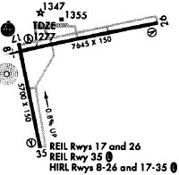
Runways
Runway Summary
| Runways: | 08/26 17/35 |
| Longest Runway: | 08/26 is 7723 ft (2354 m) long |
| Runways with an Instrument Approach: | 08, 35 |
CWA Airport Runway Details
| Runway 08/26 | 7723 ft x 150 ft (2354 m x 46 m) | |
| Runway Length Source: | 3RD PARTY SURVEY as of 11/03/2022 | |
| Surface: | Concrete - Good condition - Saw-cut or plastic grooved | |
| Runway Pavement Class: | 67 /R/B/W/T | |
| Runway Edge Lights: | High Intensity | |
Runway Weight Bearing Capacity (in thousands of pounds) |
||
| Single Wheel Landing Gear: | 120.0 | |
| Dual Wheel Landing Gear: | 227.0 | |
| Dual Tandem Wheel Landing Gear: | 409.0 | |
Runway 08 |
Runway 26 |
|
Elevation: |
1274.0 | 1260.2 |
Latitude: |
44-46-48.3827N | 44-47-05.0445N |
Longitude: |
089-40-26.8903W | 089-38-42.4102W |
|
Runway True Alignment: |
077 | 257 |
ILS Type: |
ILS/DME | |
Glide Path Angle: |
3.0 degrees | 3.0 degrees |
Traffic Pattern: |
Left | Left |
Runway Markings Type: |
Precision Instrument | Nonprecision Instrument |
Runway Markings Condition: |
Good | Fair |
Object at End: |
BLDG | |
Object Height: |
18 | |
Distance from End: |
960 | |
Object Centerline Offset: |
400 ft. left of centerline | |
Visual Glide Slope Indicators: |
4-Light PAPI On Right Side Of Runway | 4-Light PAPI On Left Side Of Runway |
Approach Light System: |
1,400 Foot Medium Intensity Approach Lighting System With Runway Alignment Indicator Lights | |
REIL: |
No | Yes |
Touchdown Lights: |
No | No |
Centerline Lights: |
No | No |
Threshold Crossing Height: |
55 | 45 |
Declared Distances |
||
Take Off Run Avbl. (TORA): |
7629 | 7723 |
Take Off Distance Avbl. (TODA): |
7629 | 7723 |
Actual Stop Dist. Avbl. (ASDA): |
7629 | 7723 |
Landing Dist. Avbl. (LDA): |
7723 | 7629 |
| Runway 17/35 | 6501 ft x 150 ft (1982 m x 46 m) | |
| Runway Length Source: | 3RD PARTY SURVEY as of 11/08/2009 | |
| Surface: | Concrete - Good condition - Saw-cut or plastic grooved | |
| Runway Pavement Class: | 65 /R/A/W/T | |
| Runway Edge Lights: | High Intensity | |
Runway Weight Bearing Capacity (in thousands of pounds) |
||
| Single Wheel Landing Gear: | 120.0 | |
| Dual Wheel Landing Gear: | 225.0 | |
| Dual Tandem Wheel Landing Gear: | 485.0 | |
| Dual Dual Tandem Wheel Landing Gear: | 980.0 | |
Runway 17 |
Runway 35 |
|
Elevation: |
1277.2 | 1225.2 |
Latitude: |
44-46-51.7881N | 44-45-48.5711N |
Longitude: |
089-40-31.9492W | 089-40-16.3708W |
|
Runway True Alignment: |
170 | 350 |
ILS Type: |
ILS/DME | |
Glide Path Angle: |
3.0 degrees | 3.0 degrees |
Traffic Pattern: |
Left | Left |
Runway Markings Type: |
Nonprecision Instrument | Precision Instrument |
Runway Markings Condition: |
Good | Good |
Object at End: |
STACK | |
Object Height: |
82 | |
Distance from End: |
2720 | |
Object Centerline Offset: |
400 ft. left of centerline | |
Visual Glide Slope Indicators: |
4-Light PAPI On Left Side Of Runway | 4-Light PAPI On Left Side Of Runway |
Approach Light System: |
1,400 Foot Medium Intensity Approach Lighting System With Runway Alignment Indicator Lights | |
REIL: |
Yes | |
Touchdown Lights: |
No | No |
Centerline Lights: |
No | No |
Threshold Crossing Height: |
45 | 50 |
Declared Distances |
||
Take Off Run Avbl. (TORA): |
6501 | 6501 |
Take Off Distance Avbl. (TODA): |
6501 | 6501 |
Actual Stop Dist. Avbl. (ASDA): |
6501 | 6501 |
Landing Dist. Avbl. (LDA): |
6501 | 6501 |
Services
Airframe Repair: |
Major |
Powerplant Repair: |
Major |
Bottled Oxygen: |
None |
Bulk Oxygen: |
None |
Fuel Available: |
100LL, Jet A |
Landing Fees: |
No |
Parking: |
Tiedowns available |
Maps & Diagrams
CWA Sectional
Flight Planning
at skyvector.com
at skyvector.com