Location
Latitude: |
37-48-01.6000N (37.800444) |
Longitude: |
096-47-56.5000W (-96.799028) |
Elevation: |
1385.0 feet MSL (422 m MSL) |
Magnetic Variation: |
2.7 E (as of April 2024 from WMM2020 model) |
Time Zone: |
UTC -6.0 (Standard Time) UTC -5.0 (Daylight Savings Time) |
From City: |
03 N.M. SE of El Dorado, Kansas |
Found On: |
Kansas City Chart |
FAA Region: |
ACE |
Contacts
Manager: |
Privately owned: |
| BRENT A. PATTY 1761 SE BLUESTEM ROAD EL DORADO, KS 67042 316-321-9192 |
BRENT A. PATTY 1761 SE BLUESTEM ROAD EL DORADO, KS 67042 316-321-9192 |
Operations
Airport Status: |
Operational |
Facility Use: |
Public |
Type: |
Airport |
Activation Date: |
05/1963 |
Control tower: |
No |
Attendance (Months/Days/Hours): |
Months/Days/Hours Unattended |
Boundary ARTCC: |
ZKC (Kansas City) |
Responsible ARTCC: |
ZKC (Kansas City) |
Segmented Circle Indicator: |
No |
Traffic Pattern Altitude (MSL): |
2385 feet (727 m) |
NOTAMs Facility: |
ICT |
NOTAM-D Service: |
Yes |
Based Aircraft
| Single Engine: | 2 |
Annual Operations (as of 08/02/2020)
| Total Operations: | 650 | |
| GA Local: | 600 | 92.3% |
| GA Itinerant: | 50 | 7.7% |
Communications
| CTAF: | 122.900 |
Fixed Based Operators (FBOs) & Fuel
(Click on a business for detail)
Please help us keep this information up to date. This is a FREE SERVICE just like everything else on Airport Guide! If you see that a business needs to be added, modified, or deleted please fill out our Update Form.
To add, modify, or delete a business click here.
Please help us keep this information up to date. This is a FREE SERVICE just like everything else on Airport Guide! If you see that a business needs to be added, modified, or deleted please fill out our Update Form.
Area Code: 316 |
| Business Name | Frequency | Phone | Fuel Grade |
|---|
Flight Service Stations
| Primary | Alternate | |
| FSS on Field: | N | |
| FSS Name (ID): | Wichita(ICT) | |
| Frequency: | ||
| Toll Free Phone: | 1-800-WX-BRIEF |
Instrument Procedures / Charts
Terminal Procedures are only available for airports in several countries with more being added all the time. If you are looking for a specific country's charts, please send an email to support(at)airportguide.com stating the country name. This will be used to prioritize the implementation.
Navigation Aids (Navaids) near 9K6
| Dist (NM) | ID | Morse Code | Name | Type | Freq | True Hdg | Mag Hdg |
|---|---|---|---|---|---|---|---|
| 24.7 | IAB | . . . _ _ . . . | Mc Connell | TACAN | 116.50 | 244 | 241 |
| 27.5 | EWK | . . _ _ _ . _ | Newton | NDB | 281 | 305 | 302 |
| 30.6 | CA | _ . _ . . _ | Harvs | NDB | 395 | 312 | 309 |
| 31.7 | ICT | . . _ . _ . _ | Wichita | VOT | 114.00 | 252 | 249 |
| 33.9 | IC | . . _ . _ . | Piche | NDB | 332 | 247 | 244 |
| 37.4 | ICT | . . _ . _ . _ | Wichita | VORTAC | 113.80 | 265 | 262 |
| 40.1 | EGT | . _ _ . _ | Wellington | NDB | 414 | 224 | 221 |
| 42.9 | EMP | . _ _ . _ _ . | Emporia | VORTAC | 112.80 | 46 | 44 |
| 44.1 | SO | . . . _ _ _ | Sawcy | NDB | 353 | 194 | 191 |
| 53.3 | MPR | _ _ . _ _ . . _ . | Mc Pherson | NDB | 227 | 308 | 305 |
| 53.5 | HRU | . . . . . _ . . . _ | Herington | NDB | 407 | 359 | 356 |
| 55.0 | HUT | . . . . . . _ _ | Hutchinson | VOR-DME | 116.80 | 282 | 279 |
| 56.8 | HU | . . . . . . _ | Saltt | NDB | 404 | 290 | 287 |
| 58.2 | CNU | _ . _ . _ . . . _ | Chanute | VOR-DME | 109.20 | 99 | 97 |
| 59.1 | UKL | . . _ _ . _ . _ . . | Boyd | NDB | 245 | 59 | 57 |
| 60.3 | PN | . _ _ . _ . | Ponca | NDB | 515 | 193 | 190 |
| 65.5 | PER | . _ _ . . . _ . | Pioneer | VORTAC | 113.20 | 195 | 192 |
| 65.6 | MSB | _ _ . . . _ . . . | Monarch | NDB | 410 | 90 | 88 |
| 66.2 | SL | . . . . _ . . | Flory | NDB | 344 | 323 | 320 |
| 68.7 | BV | _ . . . . . . _ | Dewie | NDB | 201 | 146 | 144 |
Nearby Airports with Fuel
Notices to Airmen (NOTAMS)
Remarks
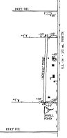
| A110-1 | WATER TOWER 1/4 MILE NE. |
| A110-3 | FOR CD CTC WICHITA APCH AT 316-350-1520. |
| A110-4 | RWY 18 42 FT TREES 300 FT FM RWY END OBSTN CLNC 7:1 |
| A110-5 | RWY 36 35 FT TREES 110 FT LEFT AND 75 FT RIGHT AT THLD |
| A17 | OWNER LIVES ON FIELD. |
| E111 | EXISTED PRIOR TO 1959. |
Runways
Runway Summary
| Runways: | 18/36 |
| Longest Runway: | 18/36 is 1800 ft (549 m) long |
| Runways with an Instrument Approach: |
9K6 Airport Runway Details
| Runway 18/36 | 1800 ft x 60 ft (549 m x 18 m) | |
| Surface: | Turf - Fair condition - No special surface treatment | |
Runway 18 |
Runway 36 |
|
Glide Path Angle: |
0.0 degrees | 0.0 degrees |
Traffic Pattern: |
Left | Left |
Object at End: |
FENCE | FENCE |
Object Height: |
4 | 4 |
Object Marked/Lighted?: |
Marked | Marked |
Distance from End: |
0 | 0 |
Object Centerline Offset: |
0 ft. left and right of centerline | 0 ft. left and right of centerline |
Services
Bottled Oxygen: |
None |
Bulk Oxygen: |
None |
Fuel Available: |
100LL |
Landing Fees: |
No |
Parking: |
Tiedowns available |
Maps & Diagrams
9K6 Sectional
Flight Planning
at skyvector.com
at skyvector.com