Location
Latitude: |
33-51-12.8900N (33.853581) |
Longitude: |
079-46-05.2280W (-79.768119) |
Elevation: |
80.2 feet MSL (24 m MSL) |
Magnetic Variation: |
8.4 W (as of April 2024 from WMM2020 model) |
Time Zone: |
UTC -5.0 (Standard Time) UTC -4.0 (Daylight Savings Time) |
From City: |
02 N.M. SW of Lake City, South Carolina |
Found On: |
Charlotte Chart |
FAA Region: |
ASO |
Contacts
Manager: |
Publicly owned: |
| DUSAN FRIDL PO BOX 1329 LAKE CITY, SC 29560 843-687-6490 |
TOWN OF LAKE CITY PO BOX 1329 LAKE CITY, SC 29560 (843) 374-5421 |
Operations
Airport Status: |
Operational |
Facility Use: |
Public |
Type: |
Airport |
Activation Date: |
01/1947 |
Control tower: |
No |
Attendance (Months/Days/Hours): |
Months/Days/Hours Unattended |
Boundary ARTCC: |
ZJX (Jacksonville) |
Responsible ARTCC: |
ZJX (Jacksonville) |
Lighting Schedule: |
SEE RMK |
Segmented Circle Indicator: |
Yes |
Traffic Pattern Altitude (MSL): |
1080 feet (329 m) |
NOTAMs Facility: |
AND |
NOTAM-D Service: |
Yes |
International Airport of Entry: |
No |
Customs Landing Rights: |
No |
Military Landing Rights: |
No |
Civil/Military Joint Use: |
No |
Based Aircraft
| Single Engine: | 4 |
| GA Helicopters: | 6 |
Annual Operations (as of 06/06/2023)
| Total Operations: | 2010 | |
| Air Taxi: | 23 | 1.1% |
| GA Local: | 1521 | 75.7% |
| GA Itinerant: | 456 | 22.7% |
| Military Aircraft: | 10 | 0.5% |
Communications
| CTAF: | 122.900 |
| Approach: | FLORENCE 135.25 135.25 JAX ARTCC |
| Departure: | FLORENCE 135.25 135.25 JAX ARTCC |
- APCH/DEP SVC PRVDD BY JACKSONVILLE ARTCC ON FREQS 133.45/306.3 (FLORENCE RCAG) WHEN FLORENCE APCH CTL CLSD.
Fixed Based Operators (FBOs) & Fuel
(Click on a business for detail)
Please help us keep this information up to date. This is a FREE SERVICE just like everything else on Airport Guide! If you see that a business needs to be added, modified, or deleted please fill out our Update Form.
To add, modify, or delete a business click here.
Please help us keep this information up to date. This is a FREE SERVICE just like everything else on Airport Guide! If you see that a business needs to be added, modified, or deleted please fill out our Update Form.
Area Code: 843 |
| Business Name | Frequency | Phone | Fuel Grade |
|---|---|---|---|
| Consolidated Aviation Services, Inc.
Update FBO info |
Unicom 122.9 | 394-1003, after hours call 394-2798 | 100LL |
Flight Service Stations
| Primary | Alternate | |
| FSS on Field: | N | |
| FSS Name (ID): | Anderson(AND) | |
| Frequency: | ||
| Toll Free Phone: | 1-800-WX-BRIEF |
Instrument Procedures / Charts
FAA Terminal Procedures valid from 0901Z 03/21/24 to 0901Z 04/18/24.
There are various types of charts available for an airport. They are listed in the Page Type column. Here is a legend for those types:
APD - Airport Diagram
DP - Departure Procedure Charts
HOT - Hot Spots
IAP - Instrument Approach Procedure Charts
MIN - Minimums
STAR - Standard Terminal Arrival Charts
| Page Type | Page Name | Volume | Action Since Last Cycle |
|---|---|---|---|
| IAP | RNAV (GPS) RWY 01 | SE-2 | |
| IAP | RNAV (GPS) RWY 19 | SE-2 | |
| MIN | TAKEOFF MINIMUMS | SE-2 |
Terminal Procedures are only available for airports in several countries with more being added all the time. If you are looking for a specific country's charts, please send an email to support(at)airportguide.com stating the country name. This will be used to prioritize the implementation.
Navigation Aids (Navaids) near 51J
| Dist (NM) | ID | Morse Code | Name | Type | Freq | True Hdg | Mag Hdg |
|---|---|---|---|---|---|---|---|
| 0.2 | CFY | _ . _ . . . _ . _ . _ _ | Evans | NDB | 420 | 41 | 49 |
| 9.2 | CKI | _ . _ . _ . _ . . | Kingstree | NDB | 404 | 208 | 216 |
| 14.3 | HEK | . . . . . _ . _ | Stuckey | NDB | 236 | 121 | 130 |
| 19.7 | FL | . . _ . . _ . . | Alcot | NDB | 335 | 347 | 355 |
| 23.4 | FLO | . . _ . . _ . . _ _ _ | Florence | VORTAC | 115.20 | 13 | 22 |
| 27.0 | PHH | . _ _ . . . . . . . . . | Andrews | NDB | 255 | 153 | 161 |
| 27.1 | MNI | _ _ _ . . . | Manning | NDB | 381 | 234 | 242 |
| 29.4 | MAO | _ _ . _ _ _ _ | Marion | NDB | 388 | 47 | 56 |
| 30.6 | SMS | . . . _ _ . . . | Sumter | NDB | 252 | 285 | 293 |
| 31.9 | HYW | . . . . _ . _ _ . _ _ | Horry | NDB | 370 | 93 | 102 |
| 35.5 | SSC | . . . . . . _ . _ . | Shaw | TACAN | 110.10 | 282 | 290 |
| 35.9 | UDG | . . _ _ . . _ _ . | Darlington | NDB | 245 | 350 | 358 |
| 37.5 | HVS | . . . . . . . _ . . . | Hartsville | NDB | 341 | 332 | 340 |
| 39.2 | GGE | _ _ . _ _ . . | Georgetown | NDB | 242 | 145 | 154 |
| 40.9 | VAN | . . . _ . _ _ . | Vance | VORTAC | 110.40 | 236 | 244 |
| 40.9 | DLC | _ . . . _ . . _ . _ . | Dillon | NDB | 274 | 28 | 37 |
| 46.0 | BES | _ . . . . . . . | Bennettsville | NDB | 230 | 2 | 11 |
| 51.7 | MMT | _ _ _ _ _ | Mc Entire | VORTAC | 113.20 | 274 | 282 |
| 52.0 | JB | . _ _ _ _ . . . | Jigel | NDB | 384 | 36 | 45 |
| 52.1 | CRE | _ . _ . . _ . . | Grand Strand | VORTAC | 114.40 | 92 | 101 |
Nearby Airports with Fuel
Notices to Airmen (NOTAMS)
Remarks
| A11 | TOWN ADMIR IS STEPHANIE SNOWDEN. |
| A110-1 | RWY 19 TWO RDO TOWERS 1 1/2-1 3/4 MI. FROM END RIGHT OF CNTRLN; ALSO LGTD WATER TANK 3/4 MI FROM END. |
| A110-2 | FOR CD CTC FLORENCE APCH AT 843-665-0632, WHEN APCH CLSD CTC JACKSONVILLE ARTCC AT 904-845-1592. |
| A33-01/19 | CRACKS HAVE BEEN FILLED AND RWY PAVEMENT REJUVENATOR APPLIED. |
| A50-01 | CLOSE-IN TREELINE 169 FT L OF CNTRLN ON RWY 01 APCH. |
| A81-APT | ACTVT MIRL RWY 01/19 - CTAF. |
| E111 | EXISTED PRIOR TO 1958. |
Runways
Runway Summary
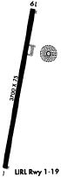
| Runways: | 01/19 |
| Longest Runway: | 01/19 is 3700 ft (1128 m) long |
| Runways with an Instrument Approach: |
51J Airport Runway Details
| Runway 01/19 | 3700 ft x 75 ft (1128 m x 23 m) | |
| Runway Length Source: | STATE as of 04/25/2005 | |
| Surface: | Asphalt - Good condition - No special surface treatment | |
| Runway Edge Lights: | Medium Intensity | |
Runway Weight Bearing Capacity (in thousands of pounds) |
||
| Single Wheel Landing Gear: | 10.0 | |
Runway 01 |
Runway 19 |
|
Elevation: |
80.1 | 80.1 |
Latitude: |
33-50-54.7010N | 33-51-31.0790N |
Longitude: |
079-46-07.6020W | 079-46-02.8530W |
|
Runway True Alignment: |
006 | 186 |
Glide Path Angle: |
3.0 degrees | 3.0 degrees |
Traffic Pattern: |
Left | Left |
Runway Markings Type: |
Nonprecision Instrument | Nonprecision Instrument |
Runway Markings Condition: |
Good | Good |
Object at End: |
TREE | TREE |
Object Height: |
71 | 74 |
Distance from End: |
1096 | 1160 |
Object Centerline Offset: |
232 ft. right of centerline | 180 ft. right of centerline |
Visual Glide Slope Indicators: |
2-Box VASI On Left Side Of Runway | 2-Box VASI On Left Side Of Runway |
Threshold Crossing Height: |
25 | 25 |
Services
Airframe Repair: |
Major |
Powerplant Repair: |
Major |
Bottled Oxygen: |
None |
Bulk Oxygen: |
None |
Fuel Available: |
100LL, Jet A-1+ |
Landing Fees: |
No |
Parking: |
Hangars and tiedowns available |
Maps & Diagrams
51J Sectional
Flight Planning
at skyvector.com
at skyvector.com