Location
Latitude: |
29-51-01.2000N (29.850333) |
Longitude: |
097-40-20.7000W (-97.672417) |
Elevation: |
531.6 feet MSL (162 m MSL) |
Magnetic Variation: |
3.2 E (as of April 2024 from WMM2020 model) |
Time Zone: |
UTC -6.0 (Standard Time) UTC -5.0 (Daylight Savings Time) |
From City: |
02 N.M. S of Lockhart, Texas |
Found On: |
San Antonio Chart |
FAA Region: |
ASW |
Contacts
Manager: |
Publicly owned: |
| SEAN KELLEY PO BOX 239 LOCKHART, TX 78644 512-398-6452 |
CITY OF LOCKHART PO BOX 239 LOCKHART, TX 78644 512-398-3461 |
Operations
Airport Status: |
Operational |
Facility Use: |
Public |
Type: |
Airport |
Activation Date: |
11/1949 |
Control tower: |
No |
Attendance (Months/Days/Hours): |
Months/Days/Hours ALL/ALL/0800-1700 |
Boundary ARTCC: |
ZHU (Houston) |
Responsible ARTCC: |
ZHU (Houston) |
Lighting Schedule: |
SEE RMK |
Segmented Circle Indicator: |
Yes |
Traffic Pattern Altitude (MSL): |
1532 feet (467 m) |
NOTAMs Facility: |
SJT |
NOTAM-D Service: |
Yes |
International Airport of Entry: |
No |
Customs Landing Rights: |
No |
Military Landing Rights: |
No |
Civil/Military Joint Use: |
No |
Based Aircraft
| Single Engine: | 33 |
| Multi Engine: | 1 |
Annual Operations (as of 05/30/2023)
| Total Operations: | 18176 | |
| Air Taxi: | 76 | 0.4% |
| GA Local: | 11800 | 64.9% |
| GA Itinerant: | 3800 | 20.9% |
| Military Aircraft: | 2500 | 13.8% |
Communications
| CTAF: | 122.800 |
| Unicom: | 122.800 |
| Approach: | AUSTIN 120.875 120.875 |
| Departure: | AUSTIN 120.875 120.875 |
Fixed Based Operators (FBOs) & Fuel
(Click on a business for detail)
Please help us keep this information up to date. This is a FREE SERVICE just like everything else on Airport Guide! If you see that a business needs to be added, modified, or deleted please fill out our Update Form.
To add, modify, or delete a business click here.
Please help us keep this information up to date. This is a FREE SERVICE just like everything else on Airport Guide! If you see that a business needs to be added, modified, or deleted please fill out our Update Form.
Area Code: 512 |
| Business Name | Frequency | Phone | Fuel Grade |
|---|
Flight Service Stations
| Primary | Alternate | |
| FSS on Field: | N | |
| FSS Name (ID): | San Angelo(SJT) | |
| Frequency: | ||
| Toll Free Phone: | 1-800-WX-BRIEF |
Instrument Procedures / Charts
FAA Terminal Procedures valid from 0901Z 03/21/24 to 0901Z 04/18/24.
There are various types of charts available for an airport. They are listed in the Page Type column. Here is a legend for those types:
APD - Airport Diagram
DP - Departure Procedure Charts
HOT - Hot Spots
IAP - Instrument Approach Procedure Charts
MIN - Minimums
STAR - Standard Terminal Arrival Charts
| Page Type | Page Name | Volume | Action Since Last Cycle |
|---|---|---|---|
| IAP | RNAV (GPS) RWY 18 | SC-3 | |
| IAP | RNAV (GPS) RWY 36 | SC-3 | |
| MIN | TAKEOFF MINIMUMS | SC-3 |
Terminal Procedures are only available for airports in several countries with more being added all the time. If you are looking for a specific country's charts, please send an email to support(at)airportguide.com stating the country name. This will be used to prioritize the implementation.
Navigation Aids (Navaids) near 50R
| Dist (NM) | ID | Morse Code | Name | Type | Freq | True Hdg | Mag Hdg |
|---|---|---|---|---|---|---|---|
| 14.4 | BS | _ . . . . . . | Creed | NDB | 255 | 359 | 356 |
| 15.8 | RU | . _ . . . _ | Garys | NDB | 272 | 294 | 291 |
| 32.5 | CWK | _ . _ . . _ _ _ . _ | Centex | VORTAC | 112.80 | 13 | 10 |
| 36.3 | DHK | _ . . . . . . _ . _ | Randolph | TACAN | 109.90 | 238 | 235 |
| 37.6 | RND | . _ . _ . _ . . | Randolph | VORTAC | 112.30 | 238 | 235 |
| 42.6 | OKT | _ _ _ _ . _ _ | Yoakum | NDB | 350 | 139 | 136 |
| 42.9 | SAT | . . . . _ _ | San Antonio | VORTAC | 116.80 | 253 | 250 |
| 45.7 | SAT | . . . . _ _ | San Antonio | VOT | 110.40 | 245 | 242 |
| 49.0 | AN | . _ _ . | Alamo | NDB | 368 | 252 | 249 |
| 50.0 | GUO | _ _ . . . _ _ _ _ | Georgetown | NDB | 332 | 359 | 356 |
| 53.7 | SSF | . . . . . . . . _ . | Stinson | VOR | 108.40 | 228 | 225 |
| 54.8 | KSY | _ . _ . . . _ . _ _ | Kelly | TACAN | 112.00 | 240 | 237 |
| 57.8 | STV | . . . _ . . . _ | Stonewall | VORTAC | 113.80 | 291 | 288 |
| 58.1 | IDU | . . _ . . . . _ | Industry | VORTAC | 110.20 | 83 | 80 |
| 60.9 | BMQ | _ . . . _ _ _ _ . _ | Burnet | NDB | 341 | 331 | 328 |
| 67.6 | VCT | . . . _ _ . _ . _ | Victoria | VOR-DME | 109.00 | 147 | 144 |
| 70.5 | IL | . . . _ . . | Iresh | NDB | 278 | 358 | 355 |
| 71.3 | GRK | _ _ . . _ . _ . _ | Gray | VOR-DME | 111.80 | 354 | 351 |
| 71.5 | ELA | . . _ . . . _ | Eagle Lake | DME | 116.4 | 98 | 95 |
| 76.8 | HLR | . . . . . _ . . . _ . | Hood | NDB | 347 | 358 | 355 |
Nearby Airports with Fuel
Notices to Airmen (NOTAMS)
Remarks
| A110*G | THIS AIRPORT HAS BEEN SURVEYED BY THE NATIONAL GEODETIC SURVEY. |
| A110-1 | +280 FT LGTD WATER TWR 2.1 MI S OF RWY 36. |
| A110-2 | PARL TWY GREEN REFLECTORS ON CL. |
| A110-3 | WILDLIFE INVOF ARPT. |
| A110-4 | FOR CD CTC AUSTIN APCH AT 512-369-7865. |
| A14 | PUBLIC WORKS |
| A17 | EXCP MAJOR HOL. |
| A42-18 | MKGS DISCOLORED, PEELING. |
| A42-36 | MKGS DISCOLORED, PEELING. |
| A58-36 | 12 FT TREE, 10 FT DSTC 174 FT L. |
| A81-APT | DUSK-DAWN. MIRL RWY 18/36 PRESET LOW INTST; TO INCR INTST ACTVT - CTAF. |
| E111 | PRE DATES THE ACT. |
Runways
Runway Summary
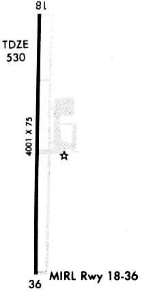
| Runways: | 18/36 |
| Longest Runway: | 18/36 is 4001 ft (1220 m) long |
| Runways with an Instrument Approach: |
50R Airport Runway Details
| Runway 18/36 | 4001 ft x 75 ft (1220 m x 23 m) | |
| Runway Length Source: | NGS as of 03/06/2008 | |
| Surface: | Asphalt - Fair condition - No special surface treatment | |
| Runway Edge Lights: | Medium Intensity | |
Runway Weight Bearing Capacity (in thousands of pounds) |
||
| Single Wheel Landing Gear: | 12.5 | |
Runway 18 |
Runway 36 |
|
Elevation: |
531.5 | 524.0 |
Latitude: |
29-51-20.9768N | 29-50-41.3923N |
Longitude: |
097-40-19.9057W | 097-40-21.4624W |
|
Runway True Alignment: |
182 | 002 |
Glide Path Angle: |
3.5 degrees | 3.0 degrees |
Traffic Pattern: |
Left | Left |
Runway Markings Type: |
Nonprecision Instrument | Nonprecision Instrument |
Runway Markings Condition: |
Poor | Poor |
Object at End: |
TREE | TREE |
Object Height: |
8 | 16 |
Distance from End: |
348 | 221 |
Object Centerline Offset: |
215 ft. left of centerline | 2149 ft. left of centerline |
Visual Glide Slope Indicators: |
2-Light PAPI On Left Side Of Runway | 2-Light PAPI On Left Side Of Runway |
Threshold Crossing Height: |
24 | 25 |
Services
Airframe Repair: |
Major |
Powerplant Repair: |
Major |
Fuel Available: |
100LL |
Landing Fees: |
No |
Parking: |
Tiedowns available |
Maps & Diagrams
50R Sectional
Flight Planning
at skyvector.com
at skyvector.com