Location
Latitude: |
37-26-07.3120N (37.435364) |
Longitude: |
095-38-46.0280W (-95.646119) |
Elevation: |
841.0 feet MSL (256 m MSL) |
Magnetic Variation: |
1.9 E (as of April 2024 from WMM2020 model) |
Time Zone: |
UTC -6.0 (Standard Time) UTC -5.0 (Daylight Savings Time) |
From City: |
02 N.M. NE of Neodesha, Kansas |
Found On: |
Kansas City Chart |
FAA Region: |
ACE |
Contacts
Manager: |
Publicly owned: |
| JEREMY JOHNSON PO BOX 336 NEODESHA, KS 66757 620-288-9264 |
CITY OF NEODESHA PO BOX 336 NEODESHA, KS 66757 620-325-2828 |
Operations
Airport Status: |
Operational |
Facility Use: |
Public |
Type: |
Airport |
Activation Date: |
08/1949 |
Control tower: |
No |
Attendance (Months/Days/Hours): |
Months/Days/Hours Unattended |
Boundary ARTCC: |
ZKC (Kansas City) |
Responsible ARTCC: |
ZKC (Kansas City) |
Lighting Schedule: |
SS-SR |
Segmented Circle Indicator: |
Yes |
Traffic Pattern Altitude (MSL): |
1841 feet (561 m) |
NOTAMs Facility: |
ICT |
NOTAM-D Service: |
Yes |
International Airport of Entry: |
No |
Customs Landing Rights: |
No |
Military Landing Rights: |
Yes |
Civil/Military Joint Use: |
No |
Based Aircraft
| Single Engine: | 2 |
Annual Operations (as of 06/06/2017)
| Total Operations: | 1220 | |
| Air Taxi: | 20 | 1.6% |
| GA Local: | 800 | 65.6% |
| GA Itinerant: | 400 | 32.8% |
Communications
| CTAF: | 122.800 |
| Unicom: | 122.800 |
- APCH/DEP CTL SVC PRVDD BY KANSAS CITY ARTCC (ZKC) ON FREQS 132.9/279.5 (CHANUTE RCAG).
Fixed Based Operators (FBOs) & Fuel
(Click on a business for detail)
Please help us keep this information up to date. This is a FREE SERVICE just like everything else on Airport Guide! If you see that a business needs to be added, modified, or deleted please fill out our Update Form.
To add, modify, or delete a business click here.
Please help us keep this information up to date. This is a FREE SERVICE just like everything else on Airport Guide! If you see that a business needs to be added, modified, or deleted please fill out our Update Form.
Area Code: 620 |
| Business Name | Frequency | Phone | Fuel Grade |
|---|
Flight Service Stations
| Primary | Alternate | |
| FSS on Field: | N | |
| FSS Name (ID): | Wichita(ICT) | |
| Frequency: | ||
| Toll Free Phone: | 1-800-WX-BRIEF |
Instrument Procedures / Charts
FAA Terminal Procedures valid from 0901Z 03/21/24 to 0901Z 04/18/24.
There are various types of charts available for an airport. They are listed in the Page Type column. Here is a legend for those types:
APD - Airport Diagram
DP - Departure Procedure Charts
HOT - Hot Spots
IAP - Instrument Approach Procedure Charts
MIN - Minimums
STAR - Standard Terminal Arrival Charts
| Page Type | Page Name | Volume | Action Since Last Cycle |
|---|---|---|---|
| IAP | RNAV (GPS)-A | NC-2 | |
| MIN | TAKEOFF MINIMUMS | NC-2 |
Terminal Procedures are only available for airports in several countries with more being added all the time. If you are looking for a specific country's charts, please send an email to support(at)airportguide.com stating the country name. This will be used to prioritize the implementation.
Navigation Aids (Navaids) near 2K7
| Dist (NM) | ID | Morse Code | Name | Type | Freq | True Hdg | Mag Hdg |
|---|---|---|---|---|---|---|---|
| 11.7 | CNU | _ . _ . _ . . . _ | Chanute | VOR-DME | 109.20 | 12 | 10 |
| 20.8 | CFV | _ . _ . . . _ . . . . _ | Coffeyville | NDB | 212 | 170 | 168 |
| 24.0 | MSB | _ _ . . . _ . . . | Monarch | NDB | 410 | 27 | 25 |
| 26.9 | OSW | _ _ _ . . . . _ _ | Oswego | DME | 117.6 | 128 | 126 |
| 39.8 | BV | _ . . . . . . _ | Dewie | NDB | 201 | 206 | 204 |
| 40.2 | BVO | _ . . . . . . _ _ _ _ | Bartlesville | VOR-DME | 117.90 | 206 | 204 |
| 43.8 | PTS | . _ _ . _ . . . | Pittsburg | NDB | 365 | 89 | 87 |
| 47.1 | FSK | . . _ . . . . _ . _ | Fort Scott | NDB | 379 | 62 | 60 |
| 52.0 | UKL | . . _ _ . _ . _ . . | Boyd | NDB | 245 | 356 | 354 |
| 53.7 | JL | . _ _ _ . _ . . | Lunns | NDB | 344 | 104 | 102 |
| 56.4 | EMP | . _ _ . _ _ . | Emporia | VORTAC | 112.80 | 335 | 333 |
| 63.7 | LLU | . _ . . . _ . . . . _ | Spring River | NDB | 356 | 86 | 85 |
| 68.0 | EOS | . _ _ _ . . . | Neosho | DME | 117.3 | 121 | 120 |
| 69.5 | SO | . . . _ _ _ | Sawcy | NDB | 353 | 253 | 251 |
| 74.4 | BUM | _ . . . . . _ _ _ | Butler | VORTAC | 115.90 | 47 | 46 |
| 74.7 | TUL | _ . . _ . _ . . | Tulsa | VORTAC | 114.40 | 185 | 183 |
| 75.0 | TUL | _ . . _ . _ . . | Tulsa Intl | VOT | 109.00 | 188 | 186 |
| 78.0 | IAB | . . . _ _ . . . | Mc Connell | TACAN | 116.50 | 278 | 276 |
| 78.6 | PN | . _ _ . _ . | Ponca | NDB | 515 | 242 | 240 |
| 79.6 | OWP | _ _ _ . _ _ . _ _ . | William Pogue | NDB | 362 | 198 | 196 |
Nearby Airports with Fuel
Notices to Airmen (NOTAMS)
Remarks
| A110*G | THIS AIRPORT HAS BEEN SURVEYED BY THE NATIONAL GEODETIC SURVEY. |
| A110-1 | ULTRALIGHT ACTIVITY ON AND INVOF ARPT. |
| A110-2 | WILDLIFE ON & INVOF ARPT. |
| A110-3 | FOR CD CTC KANSAS CITY ARTCC AT 913-254-8508. |
| A16 | EVENING CALL 620-920-0348 |
| A33-02/20 | MEDIUM/HIGH SEVERITY TRANSVERSE CRACKING LENGTH OF RWY 02/20. |
| A40-02/20 | NSTD LIRL; ALL CLEAR LENSES. |
| A42-15 | WHITE BARREL MARKERS ON BOTH ENDS. |
| A58-20 | + 5 FT FENCE POST 190 FT FM RWY 20; 96 FT RIGHT OF CL |
| E111 | ESTABLISHED PRIOR TO 1959. |
Runways
Runway Summary
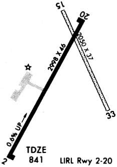
| Runways: | 02/20 15/33 |
| Longest Runway: | 02/20 is 2998 ft (914 m) long |
| Runways with an Instrument Approach: |
2K7 Airport Runway Details
| Runway 02/20 | 2998 ft x 46 ft (914 m x 14 m) | |
| Surface: | Asphalt - Poor condition - No special surface treatment | |
| Runway Edge Lights: | Low Intensity | |
Runway Weight Bearing Capacity (in thousands of pounds) |
||
| Single Wheel Landing Gear: | 11.0 | |
Runway 02 |
Runway 20 |
|
Elevation: |
822.0 | 841.0 |
Latitude: |
37-25-51.9460N | 37-26-17.9450N |
Longitude: |
095-38-58.9740W | 095-38-41.1250W |
|
Runway True Alignment: |
029 | 209 |
Glide Path Angle: |
0.0 degrees | 0.0 degrees |
Traffic Pattern: |
Left | Left |
Runway Markings Type: |
Basic | Basic |
Runway Markings Condition: |
Fair | Fair |
Object at End: |
TREES | |
Object Height: |
68 | |
Distance from End: |
823 | |
Object Centerline Offset: |
106 ft. right of centerline | |
REIL: |
No | No |
| Runway 15/33 | 2100 ft x 45 ft (640 m x 14 m) | |
| Runway Length Source: | FAA as of 01/31/2012 | |
| Surface: | Asphalt - Poor condition - No special surface treatment | |
Runway 15 |
Runway 33 |
|
Elevation: |
840.0 | 825.0 |
Latitude: |
37-26-20.2110N | 37-26-01.2120N |
Longitude: |
095-38-45.4290W | 095-38-34.9280W |
|
Runway True Alignment: |
156 | 336 |
Glide Path Angle: |
0.0 degrees | 0.0 degrees |
Runway Markings Condition: |
Fair | Fair |
Object at End: |
TREE | |
Object Height: |
35 | |
Distance from End: |
440 | |
Object Centerline Offset: |
106 ft. right of centerline |
Services
Airframe Repair: |
None |
Powerplant Repair: |
None |
Bottled Oxygen: |
None |
Bulk Oxygen: |
None |
Fuel Available: |
100LL, Jet A |
Landing Fees: |
No |
Parking: |
Hangars and tiedowns available |
Maps & Diagrams
2K7 Sectional
Flight Planning
at skyvector.com
at skyvector.com