Location
Latitude: |
31-17-52.2470N (31.297846) |
Longitude: |
089-48-41.3530W (-89.811487) |
Elevation: |
270.2 feet MSL (82 m MSL) |
Magnetic Variation: |
1.7 W (as of April 2024 from WMM2020 model) |
Time Zone: |
UTC -6.0 (Standard Time) UTC -5.0 (Daylight Savings Time) |
From City: |
03 N.M. N of Columbia, Mississippi |
Found On: |
New Orleans Chart |
FAA Region: |
ASO |
Contacts
Manager: |
Publicly owned: |
| DAVID DECLEMENT 151 AIRPORT ROAD COLUMBIA, MS 39429 601-736-9295 |
CITY OF COLUMBIA & MARION CO CITY HALL COLUMBIA, MS 39429 601-736-8201 |
Operations
Airport Status: |
Operational |
Facility Use: |
Public |
Type: |
Airport |
Activation Date: |
05/1941 |
Control tower: |
No |
Attendance (Months/Days/Hours): |
Months/Days/Hours ON CALL |
Boundary ARTCC: |
ZHU (Houston) |
Responsible ARTCC: |
ZHU (Houston) |
Lighting Schedule: |
SEE RMK |
Segmented Circle Indicator: |
Yes |
Traffic Pattern Altitude (MSL): |
1270 feet (387 m) |
NOTAMs Facility: |
GWO |
NOTAM-D Service: |
Yes |
International Airport of Entry: |
No |
Customs Landing Rights: |
No |
Military Landing Rights: |
Yes |
Civil/Military Joint Use: |
No |
Based Aircraft
| Single Engine: | 26 |
| Multi Engine: | 1 |
| Jet Engine: | 1 |
| GA Helicopters: | 1 |
Annual Operations (as of 05/18/2023)
| Total Operations: | 23416 | |
| GA Local: | 7172 | 30.6% |
| GA Itinerant: | 15244 | 65.1% |
| Military Aircraft: | 1000 | 4.3% |
Communications
| CTAF: | 122.800 |
| Unicom: | 122.800 |
| AWOS-3PT: | 120.675 (601-736-4983) |
- APCH/DEP CTL SVC PRVDD BY HOUSTON ARTCC (ZHU) ON FREQS 126.8/327.8 (MC COMB RCAG).
Fixed Based Operators (FBOs) & Fuel
(Click on a business for detail)
Please help us keep this information up to date. This is a FREE SERVICE just like everything else on Airport Guide! If you see that a business needs to be added, modified, or deleted please fill out our Update Form.
To add, modify, or delete a business click here.
Please help us keep this information up to date. This is a FREE SERVICE just like everything else on Airport Guide! If you see that a business needs to be added, modified, or deleted please fill out our Update Form.
Area Code: 601 |
| Business Name | Frequency | Phone | Fuel Grade |
|---|
Flight Service Stations
| Primary | Alternate | |
| FSS on Field: | N | |
| FSS Name (ID): | Greenwood(GWO) | |
| Frequency: | ||
| Toll Free Phone: | 1-800-WX-BRIEF |
Instrument Procedures / Charts
FAA Terminal Procedures valid from 0901Z 03/21/24 to 0901Z 04/18/24.
There are various types of charts available for an airport. They are listed in the Page Type column. Here is a legend for those types:
APD - Airport Diagram
DP - Departure Procedure Charts
HOT - Hot Spots
IAP - Instrument Approach Procedure Charts
MIN - Minimums
STAR - Standard Terminal Arrival Charts
| Page Type | Page Name | Volume | Action Since Last Cycle |
|---|---|---|---|
| IAP | RNAV (GPS) RWY 05 | SC-4 | |
| IAP | RNAV (GPS) RWY 23 | SC-4 | |
| MIN | ALTERNATE MINIMUMS | SC-4 | |
| MIN | TAKEOFF MINIMUMS | SC-4 |
Terminal Procedures are only available for airports in several countries with more being added all the time. If you are looking for a specific country's charts, please send an email to support(at)airportguide.com stating the country name. This will be used to prioritize the implementation.
Navigation Aids (Navaids) near 0R0
| Dist (NM) | ID | Morse Code | Name | Type | Freq | True Hdg | Mag Hdg |
|---|---|---|---|---|---|---|---|
| 22.9 | MCB | _ _ _ . _ . _ . . . | Mc Comb | VORTAC | 116.70 | 271 | 273 |
| 25.1 | GVB | _ _ . . . . _ _ . . . | Bogalusa | NDB | 353 | 185 | 187 |
| 25.3 | LBY | . _ . . _ . . . _ . _ _ | Eaton | VORTAC | 110.60 | 73 | 75 |
| 35.9 | MC | _ _ _ . _ . | Ferni | NDB | 413 | 266 | 267 |
| 39.5 | THJ | _ . . . . . _ _ _ | Tallahala | NDB | 346 | 53 | 55 |
| 44.4 | PCU | . _ _ . _ . _ . . . _ | Picayune | VOR-DME | 113.95 | 174 | 176 |
| 52.0 | HP | . . . . . _ _ . | Anger | NDB | 212 | 217 | 218 |
| 54.0 | HS | . . . . . . . | Hanco | NDB | 221 | 160 | 162 |
| 56.2 | HMU | . . . . _ _ . . _ | Hammond | VOR | 109.60 | 213 | 214 |
| 59.1 | GP | _ _ . . _ _ . | Bayou | NDB | 360 | 145 | 147 |
| 62.1 | JAN | . _ _ _ . _ _ . | Jackson | VOT | 111.00 | 348 | 350 |
| 65.5 | GPT | _ _ . . _ _ . _ | Gulfport | VORTAC | 109.00 | 144 | 146 |
| 67.5 | RYB | . _ . _ . _ _ _ . . . | Raymond | NDB | 375 | 333 | 335 |
| 68.7 | JA | . _ _ _ . _ | Allen | NDB | 365 | 346 | 348 |
| 69.1 | GCV | _ _ . _ . _ . . . . _ | Greene County | VORTAC | 115.70 | 99 | 101 |
| 69.7 | MHZ | _ _ . . . . _ _ . . | Magnolia | VORTAC | 113.20 | 347 | 349 |
| 70.1 | BIX | _ . . . . . _ . . _ | Keesler | TACAN | 111.80 | 139 | 141 |
| 70.7 | JH | . _ _ _ . . . . | Brenz | NDB | 260 | 341 | 343 |
| 74.8 | JAN | . _ _ _ . _ _ . | Jackson | VORTAC | 112.60 | 346 | 348 |
| 77.8 | ME | _ _ . | Savoy | NDB | 356 | 42 | 44 |
Nearby Airports with Fuel
Notices to Airmen (NOTAMS)
Remarks
| A110-1 | PUB FONE AVBL 601-736-9295. |
| A110-3 | COURTESY CAR AVBL. |
| A110-4 | FOR CD CTC HOUSTON ARTCC AT 281-230-5622. |
| A17 | FOR SVC CALL 601-441-0299 OR 601-441-1867. |
| A70-FUEL-10 | 0LL FUEL SVC AVBL 24 HRS WITH CREDIT CARD. |
| A76 | INSTR AVBL 601-606-8692. |
| A81-APT | ACTVT REIL RWY 05 & 23; MIRL RWY 5/23 - CTAF. PAPI RWY 05 & 23 OPR CONSLY. |
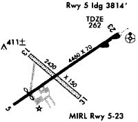
Runways
Runway Summary
| Runways: | 05/23 |
| Longest Runway: | 05/23 is 5500 ft (1676 m) long |
| Runways with an Instrument Approach: |
0R0 Airport Runway Details
| Runway 05/23 | 5500 ft x 100 ft (1676 m x 30 m) | |
| Runway Length Source: | 3RD PARTY SURVEY as of 07/20/2020 | |
| Surface: | Asphalt - Good condition - No special surface treatment | |
| Runway Pavement Class: | 23 /F/B/X/T | |
| Runway Edge Lights: | Medium Intensity | |
Runway Weight Bearing Capacity (in thousands of pounds) |
||
| Single Wheel Landing Gear: | 63.0 | |
| Dual Wheel Landing Gear: | 90.0 | |
| Dual Tandem Wheel Landing Gear: | 174.0 | |
Runway 05 |
Runway 23 |
|
Elevation: |
243.6 | 270.2 |
Latitude: |
31-17-36.1577N | 31-18-08.3345N |
Longitude: |
089-49-06.9119W | 089-48-15.7920W |
|
Runway True Alignment: |
054 | 234 |
Glide Path Angle: |
3.0 degrees | 3.0 degrees |
Traffic Pattern: |
Left | Left |
Runway Markings Type: |
Nonprecision Instrument | Nonprecision Instrument |
Runway Markings Condition: |
Good | Good |
Object at End: |
TREES | TREE |
Object Height: |
55 | 26 |
Distance from End: |
2000 | 1060 |
Object Centerline Offset: |
50 ft. left of centerline | |
Visual Glide Slope Indicators: |
4-Light PAPI On Left Side Of Runway | 4-Light PAPI On Left Side Of Runway |
REIL: |
Yes | Yes |
Threshold Crossing Height: |
42 | 43 |
Services
Airframe Repair: |
Minor |
Powerplant Repair: |
Minor |
Bottled Oxygen: |
None |
Bulk Oxygen: |
None |
Fuel Available: |
100LL, Jet A |
Landing Fees: |
No |
Parking: |
Hangars and tiedowns available |
Maps & Diagrams
0R0 Sectional
Flight Planning
at skyvector.com
at skyvector.com