Location
Latitude: |
37-02-11.8000N (37.036611) |
Longitude: |
097-35-08.0000W (-97.585556) |
Elevation: |
1157.0 feet MSL (353 m MSL) |
Magnetic Variation: |
3.2 E (as of April 2024 from WMM2020 model) |
Time Zone: |
UTC -6.0 (Standard Time) UTC -5.0 (Daylight Savings Time) |
From City: |
01 N.M. E of Caldwell, Kansas |
Found On: |
Wichita Chart |
FAA Region: |
ACE |
Contacts
Manager: |
Publicly owned: |
| JOSH VANEK 14 W. CENTRAL CALDWELL, KS 67022 620-845-6676 |
CITY OF CALDWELL 14 W. CENTRAL CALDWELL, KS 67022 620-845-6514 |
Operations
Airport Status: |
Operational |
Facility Use: |
Public |
Type: |
Airport |
Activation Date: |
12/1945 |
Control tower: |
No |
Attendance (Months/Days/Hours): |
Months/Days/Hours Unattended |
Boundary ARTCC: |
ZKC (Kansas City) |
Responsible ARTCC: |
ZKC (Kansas City) |
Segmented Circle Indicator: |
No |
Traffic Pattern Altitude (MSL): |
2157 feet (657 m) |
NOTAMs Facility: |
ICT |
NOTAM-D Service: |
Yes |
Military Landing Rights: |
No |
Civil/Military Joint Use: |
No |
Based Aircraft
| Single Engine: | 1 |
Annual Operations (as of 05/21/2021)
| Total Operations: | 900 | |
| GA Local: | 500 | 55.6% |
| GA Itinerant: | 400 | 44.4% |
Communications
| CTAF: | 122.900 |
Fixed Based Operators (FBOs) & Fuel
(Click on a business for detail)
Please help us keep this information up to date. This is a FREE SERVICE just like everything else on Airport Guide! If you see that a business needs to be added, modified, or deleted please fill out our Update Form.
To add, modify, or delete a business click here.
Please help us keep this information up to date. This is a FREE SERVICE just like everything else on Airport Guide! If you see that a business needs to be added, modified, or deleted please fill out our Update Form.
Area Code: 620 |
| Business Name | Frequency | Phone | Fuel Grade |
|---|
Flight Service Stations
| Primary | Alternate | |
| FSS on Field: | N | |
| FSS Name (ID): | Wichita(ICT) | |
| Frequency: | ||
| Toll Free Phone: | 1-800-WX-BRIEF |
Instrument Procedures / Charts
Terminal Procedures are only available for airports in several countries with more being added all the time. If you are looking for a specific country's charts, please send an email to support(at)airportguide.com stating the country name. This will be used to prioritize the implementation.
Navigation Aids (Navaids) near 01K
| Dist (NM) | ID | Morse Code | Name | Type | Freq | True Hdg | Mag Hdg |
|---|---|---|---|---|---|---|---|
| 19.6 | EGT | . _ _ . _ | Wellington | NDB | 414 | 28 | 25 |
| 26.5 | SO | . . . _ _ _ | Sawcy | NDB | 353 | 82 | 79 |
| 26.5 | PN | . _ _ . _ . | Ponca | NDB | 515 | 118 | 115 |
| 26.8 | PER | . _ _ . . . _ . | Pioneer | VORTAC | 113.20 | 130 | 127 |
| 29.0 | ANY | . _ _ . _ . _ _ | Anthony | TACAN | 112.90 | 284 | 281 |
| 33.1 | IC | . . _ . _ . | Piche | NDB | 332 | 10 | 7 |
| 36.7 | ICT | . . _ . _ . _ | Wichita | VOT | 114.00 | 11 | 8 |
| 38.2 | IAB | . . . _ _ . . . | Mc Connell | TACAN | 116.50 | 23 | 20 |
| 40.9 | ODG | _ _ _ _ . . _ _ . | Woodring | VOR-DME | 109.00 | 193 | 190 |
| 42.5 | ICT | . . _ . _ . _ | Wichita | VORTAC | 113.80 | 0 | 357 |
| 44.5 | END | . _ . _ . . | Vance | VORTAC | 115.40 | 201 | 198 |
| 46.8 | EI | . . . | Garfy | NDB | 341 | 192 | 189 |
| 53.7 | SW | . . . . _ _ | Gabeh | NDB | 255 | 153 | 150 |
| 54.5 | SWO | . . . . _ _ _ _ _ | Stillwater | VOR-DME | 108.40 | 153 | 150 |
| 60.0 | HUT | . . . . . . _ _ | Hutchinson | VOR-DME | 116.80 | 344 | 341 |
| 63.4 | EWK | . . _ _ _ . _ | Newton | NDB | 281 | 13 | 10 |
| 67.2 | HU | . . . . . . _ | Saltt | NDB | 404 | 346 | 343 |
| 68.1 | CA | _ . _ . . _ | Harvs | NDB | 395 | 12 | 9 |
| 69.1 | PTT | . _ _ . _ _ | Pratt | NDB | 356 | 307 | 303 |
| 76.1 | BVO | _ . . . . . . _ _ _ _ | Bartlesville | VOR-DME | 117.90 | 98 | 95 |
Nearby Airports with Fuel
Notices to Airmen (NOTAMS)
Remarks
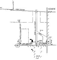
| A110-3 | 18 IN BY 140 FT METAL CULVERT IN DITCH E OF RWY ON TWY. |
| A110-4 | WIND FARM 5 S OF ARPT. |
| A110-5 | FOR CD CTC WICHITA APCH AT 316-350-1520. |
| A24 | LNDG FEE FOR COMMERCIAL USERS ONLY. |
| A30A-17 | 3 FT DITCH OFF END OF RWY. |
| A52-17 | COUNTRY ROAD - TFC DURING HARVEST. |
| A52-35 | PLINE, HWY & PLINE SUPPORT 1/8 MILE S OF ROAD. |
Runways
Runway Summary
| Runways: | 17/35 |
| Longest Runway: | 17/35 is 2460 ft (750 m) long |
| Runways with an Instrument Approach: |
01K Airport Runway Details
| Runway 17/35 | 2460 ft x 110 ft (750 m x 34 m) | |
| Surface: | Turf - Good condition - No special surface treatment | |
Runway 17 |
Runway 35 |
|
Elevation: |
1157.0 | 1135.0 |
Latitude: |
37-02-24.0086N | 37-01-59.6800N |
Longitude: |
097-35-07.9110W | 097-35-08.0954W |
|
Runway True Alignment: |
180 | 000 |
Glide Path Angle: |
0.0 degrees | 0.0 degrees |
Traffic Pattern: |
Left | Left |
Object at End: |
ROAD | ROAD |
Object Height: |
13 | 15 |
Distance from End: |
40 | 180 |
Object Centerline Offset: |
0 ft. left and right of centerline | 0 ft. left and right of centerline |
Services
Airframe Repair: |
Major |
Powerplant Repair: |
Major |
Bottled Oxygen: |
None |
Bulk Oxygen: |
Low Pressure |
Fuel Available: |
100LL, Jet A |
Landing Fees: |
No |
Parking: |
Hangars and tiedowns available |
Maps & Diagrams
01K Sectional
Flight Planning
at skyvector.com
at skyvector.com