Location
Latitude: |
31-09-06.8415N (31.1519) |
Longitude: |
097-24-27.5866W (-97.407663) |
Elevation: |
682.3 feet MSL (208 m MSL) |
Magnetic Variation: |
3 E (as of April 2024 from WMM2020 model) |
Time Zone: |
UTC -6.0 (Standard Time) UTC -5.0 (Daylight Savings Time) |
From City: |
05 N.M. NW of Temple, Texas |
Found On: |
San Antonio Chart |
FAA Region: |
ASW |
Contacts
Manager: |
Publicly owned: |
| SEAN PARKER 7720-F AIRPORT ROAD TEMPLE, TX 76501 254-298-5770 |
CITY OF TEMPLE 2 N. MAIN TEMPLE, TX 76501 254-298-5660 |
Operations
Airport Status: |
Operational |
Facility Use: |
Public |
Type: |
Airport |
Activation Date: |
07/1942 |
Control tower: |
No |
Attendance (Months/Days/Hours): |
Months/Days/Hours ALL/ALL/0700-2000 |
Boundary ARTCC: |
ZHU (Houston) |
Responsible ARTCC: |
ZFW (Fort Worth) |
Lighting Schedule: |
SEE RMK |
Segmented Circle Indicator: |
Yes |
Traffic Pattern Altitude (MSL): |
1682 feet (513 m) |
NOTAMs Facility: |
TPL |
NOTAM-D Service: |
Yes |
International Airport of Entry: |
No |
Customs Landing Rights: |
No |
Military Landing Rights: |
Yes |
Civil/Military Joint Use: |
No |
Based Aircraft
| Single Engine: | 91 |
| Multi Engine: | 13 |
| Jet Engine: | 9 |
| GA Helicopters: | 9 |
| Gliders: | 1 |
| Military Aircraft: | 147 |
Annual Operations (as of 06/09/2023)
| Total Operations: | 41124 | |
| GA Local: | 25200 | 61.3% |
| GA Itinerant: | 8400 | 20.4% |
| Military Aircraft: | 7524 | 18.3% |
Communications
| CTAF: | 123.000 |
| Unicom: | 123.000 |
| Approach: | GRAY 120.075 120.075 120.075 |
| Departure: | GRAY 120.075 120.075 120.075 |
| AWOS-3PT: | 134.975 (254-774-8337) |
Fixed Based Operators (FBOs) & Fuel
(Click on a business for detail)
Please help us keep this information up to date. This is a FREE SERVICE just like everything else on Airport Guide! If you see that a business needs to be added, modified, or deleted please fill out our Update Form.
To add, modify, or delete a business click here.
Please help us keep this information up to date. This is a FREE SERVICE just like everything else on Airport Guide! If you see that a business needs to be added, modified, or deleted please fill out our Update Form.
Area Code: 254 |
| Business Name | Frequency | Phone | Fuel Grade |
|---|---|---|---|
| Gazelle Air
Update FBO info |
778-0101 | 100LL |
Flight Service Stations
| Primary | Alternate | |
| FSS on Field: | N | |
| FSS Name (ID): | San Angelo(SJT) | |
| Frequency: | ||
| Toll Free Phone: | 1-800-WX-BRIEF |
Instrument Procedures / Charts
FAA Terminal Procedures valid from 0901Z 03/21/24 to 0901Z 04/18/24.
There are various types of charts available for an airport. They are listed in the Page Type column. Here is a legend for those types:
APD - Airport Diagram
DP - Departure Procedure Charts
HOT - Hot Spots
IAP - Instrument Approach Procedure Charts
MIN - Minimums
STAR - Standard Terminal Arrival Charts
| Page Type | Page Name | Volume | Action Since Last Cycle |
|---|---|---|---|
| IAP | ILS OR LOC RWY 16 | SC-3 | |
| IAP | RNAV (GPS) RWY 16 | SC-3 | |
| IAP | RNAV (GPS) RWY 34 | SC-3 | |
| MIN | ALTERNATE MINIMUMS | SC-3 | |
| MIN | TAKEOFF MINIMUMS | SC-3 |
Terminal Procedures are only available for airports in several countries with more being added all the time. If you are looking for a specific country's charts, please send an email to support(at)airportguide.com stating the country name. This will be used to prioritize the implementation.
Navigation Aids (Navaids) near TPL
| Dist (NM) | ID | Morse Code | Name | Type | Freq | True Hdg | Mag Hdg |
|---|---|---|---|---|---|---|---|
| 3.6 | TPL | _ . _ _ . . _ . . | Temple | DME | 110.4 | 345 | 342 |
| 15.6 | HLR | . . . . . _ . . . _ . | Hood | NDB | 347 | 265 | 262 |
| 17.2 | IL | . . . _ . . | Iresh | NDB | 278 | 243 | 240 |
| 22.1 | GRK | _ _ . . _ . _ . _ | Gray | VOR-DME | 111.80 | 251 | 248 |
| 24.2 | GR | _ _ . . _ . | Starn | NDB | 323 | 272 | 269 |
| 27.3 | ROB | . _ . _ _ _ _ . . . | Robinson | NDB | 400 | 39 | 36 |
| 31.4 | GUO | _ _ . . . _ _ _ _ | Georgetown | NDB | 332 | 206 | 203 |
| 31.4 | ACT | . _ _ . _ . _ | Waco | VORTAC | 115.30 | 13 | 10 |
| 37.7 | AGJ | . _ _ _ . . _ _ _ | Gooch Springs | VORTAC | 112.50 | 273 | 270 |
| 46.8 | CWK | _ . _ . . _ _ _ . _ | Centex | VORTAC | 112.80 | 187 | 184 |
| 47.3 | MNZ | _ _ _ . _ _ . . | Hamilton | NDB | 251 | 306 | 303 |
| 49.3 | BMQ | _ . . . _ _ _ _ . _ | Burnet | NDB | 341 | 240 | 237 |
| 51.0 | GNL | _ _ . _ . . _ . . | Groesbeck | DME | 108.8 | 59 | 56 |
| 54.4 | LXY | . _ . . _ . . _ _ . _ _ | Mexia | NDB | 329 | 57 | 54 |
| 60.5 | CLL | _ . _ . . _ . . . _ . . | College Station | VORTAC | 113.30 | 122 | 119 |
| 65.1 | JEN | . _ _ _ . _ . | Glen Rose | TACAN | 115.00 | 338 | 335 |
| 65.2 | BS | _ . . . . . . | Creed | NDB | 255 | 192 | 189 |
| 67.8 | CL | _ . _ . . _ . . | Rowdy | NDB | 260 | 125 | 122 |
| 73.8 | CRS | _ . _ . . _ . . . . | Corsicana | NDB | 396 | 44 | 41 |
| 74.0 | LOA | . _ . . _ _ _ . _ | Leona | VORTAC | 110.80 | 90 | 87 |
Nearby Airports with Fuel
Notices to Airmen (NOTAMS)
Remarks
| A110-1 | ARFF NOT AVBL 2000-0700. |
| A110-2 | MIL CONTR FUEL AVBL. |
| A110-6 | GLDR OPN 1.5 MILES NORTH OF RWY 16 THR. |
| A17 | FOR AFT HRS ATNDT 254-493-8530. |
| A26 | ARFF PROTECTION MEETS INDEX B. |
| A70-FUEL-10 | 0LL ALL FUELS FULL & SELF SVC. |
| A81-APT | DUSK-2200. ACTVT PAPI RWY 21 - CTAF. AFT 2200 MIRL RWY 16/34 PRESET LOW INTST; TO INCR INTST & ACTVT MALSR RWY 16 - CTAF. MIRL RWY 03/21 NOT AVBL AFT 2200. |
| E111 | PRE DATES ACT. |
Runways
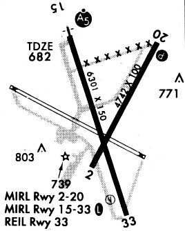
Runway Summary
| Runways: | 03/21 16/34 |
| Longest Runway: | 16/34 is 7000 ft (2134 m) long |
| Runways with an Instrument Approach: | 16 |
TPL Airport Runway Details
| Runway 03/21 | 4740 ft x 100 ft (1445 m x 30 m) | |
| Runway Length Source: | 3RD PARTY SURVEY as of 04/07/2006 | |
| Surface: | Asphalt - Good condition - No special surface treatment | |
| Runway Edge Lights: | Medium Intensity | |
Runway Weight Bearing Capacity (in thousands of pounds) |
||
| Single Wheel Landing Gear: | 31.0 | |
| Dual Wheel Landing Gear: | 37.0 | |
Runway 03 |
Runway 21 |
|
Elevation: |
674.4 | 665.1 |
Latitude: |
31-08-51.8620N | 31-09-33.4330N |
Longitude: |
097-24-34.0940W | 097-24-08.8120W |
|
Runway True Alignment: |
028 | 208 |
Glide Path Angle: |
0.0 degrees | 3.0 degrees |
Traffic Pattern: |
Left | Left |
Runway Markings Type: |
Nonprecision Instrument | Nonprecision Instrument |
Runway Markings Condition: |
Good | Good |
Visual Glide Slope Indicators: |
4-Light PAPI On Left Side Of Runway | |
Threshold Crossing Height: |
47 | |
Declared Distances |
||
Take Off Run Avbl. (TORA): |
4740 | 4740 |
Take Off Distance Avbl. (TODA): |
4740 | 4740 |
Actual Stop Dist. Avbl. (ASDA): |
4740 | 4740 |
Landing Dist. Avbl. (LDA): |
4740 | 4740 |
| Runway 16/34 | 7000 ft x 150 ft (2134 m x 46 m) | |
| Runway Length Source: | 3RD PARTY SURVEY as of 04/07/2006 | |
| Surface: | Asphalt - Good condition - Saw-cut or plastic grooved | |
| Runway Edge Lights: | Medium Intensity | |
Runway Weight Bearing Capacity (in thousands of pounds) |
||
| Single Wheel Landing Gear: | 55.0 | |
| Dual Wheel Landing Gear: | 70.0 | |
| Dual Tandem Wheel Landing Gear: | 110.0 | |
Runway 16 |
Runway 34 |
|
Elevation: |
682.3 | 669.0 |
Latitude: |
31-09-35.9700N | 31-08-29.8500N |
Longitude: |
097-24-43.7800W | 097-24-19.7100W |
|
Runway True Alignment: |
163 | 343 |
ILS Type: |
ILS/DME | |
Glide Path Angle: |
0.0 degrees | 3.0 degrees |
Traffic Pattern: |
Left | Left |
Runway Markings Type: |
Precision Instrument | Precision Instrument |
Runway Markings Condition: |
Good | Good |
Visual Glide Slope Indicators: |
4-Light PAPI On Left Side Of Runway | |
Approach Light System: |
1,400 Foot Medium Intensity Approach Lighting System With Runway Alignment Indicator Lights | |
Threshold Crossing Height: |
34 | |
Declared Distances |
||
Take Off Run Avbl. (TORA): |
7000 | 7000 |
Take Off Distance Avbl. (TODA): |
7000 | 7000 |
Actual Stop Dist. Avbl. (ASDA): |
7000 | 7000 |
Landing Dist. Avbl. (LDA): |
7000 | 7000 |
Services
Airframe Repair: |
Major |
Powerplant Repair: |
Major |
Bottled Oxygen: |
None |
Bulk Oxygen: |
None |
Fuel Available: |
100LL, Jet A |
Landing Fees: |
No |
Parking: |
Hangars and tiedowns available |
Maps & Diagrams
TPL Sectional
Flight Planning
at skyvector.com
at skyvector.com