Location
Latitude: |
40-53-03.8090N (40.884391) |
Longitude: |
078-05-14.4300W (-78.087342) |
Elevation: |
1948.0 feet MSL (594 m MSL) |
Magnetic Variation: |
10.5 W (as of April 2024 from WMM2020 model) |
Time Zone: |
UTC -5.0 (Standard Time) UTC -4.0 (Daylight Savings Time) |
From City: |
08 N.M. E of Philipsburg, Pennsylvania |
Found On: |
Detroit Chart |
FAA Region: |
AEA |
Contacts
Manager: |
Publicly owned: |
| DAVE PRYDE 451 AIRPORT ROAD PHILIPSBURG, PA 16866 814-342-1080 |
MID STATE REG ARPT AUTH 451 AIRPORT ROAD PHILIPSBURG, PA 16866 814-342-6296 |
Operations
Airport Status: |
Operational |
Facility Use: |
Public |
Type: |
Airport |
Activation Date: |
11/1938 |
Control tower: |
No |
Attendance (Months/Days/Hours): |
Months/Days/Hours Unattended |
Boundary ARTCC: |
ZNY (New York) |
Responsible ARTCC: |
ZNY (New York) |
Lighting Schedule: |
SEE RMK |
Segmented Circle Indicator: |
Yes |
Traffic Pattern Altitude (MSL): |
2948 feet (899 m) |
NOTAMs Facility: |
AOO |
NOTAM-D Service: |
Yes |
International Airport of Entry: |
No |
Customs Landing Rights: |
No |
Military Landing Rights: |
Yes |
Civil/Military Joint Use: |
No |
Based Aircraft
| Single Engine: | 2 |
| Multi Engine: | 1 |
| Gliders: | 9 |
Annual Operations (as of 05/16/2023)
| Total Operations: | 1500 | |
| GA Local: | 700 | 46.7% |
| GA Itinerant: | 500 | 33.3% |
| Military Aircraft: | 300 | 20.0% |
Communications
| CTAF: | 122.900 |
| AWOS-3: | 127.525 (814-343-4531) |
- APCH/DEP SVC PRVDD BY NEW YORK ARTCC ON FREQS 134.8/338.3 (PHILIPSBURG RCAG).
Fixed Based Operators (FBOs) & Fuel
(Click on a business for detail)
Please help us keep this information up to date. This is a FREE SERVICE just like everything else on Airport Guide! If you see that a business needs to be added, modified, or deleted please fill out our Update Form.
To add, modify, or delete a business click here.
Please help us keep this information up to date. This is a FREE SERVICE just like everything else on Airport Guide! If you see that a business needs to be added, modified, or deleted please fill out our Update Form.
Area Code: 814 |
| Business Name | Frequency | Phone | Fuel Grade |
|---|---|---|---|
| Miller-Creststar Helicopters
Update FBO info |
Unicom 123.5 | 359-4444, 800-800-4356 | 100LL, Jet A |
Flight Service Stations
| Primary | Alternate | |
| FSS on Field: | N | |
| FSS Name (ID): | Altoona(AOO) | |
| Frequency: | ||
| Toll Free Phone: | 1-800-WX-BRIEF |
Instrument Procedures / Charts
FAA Terminal Procedures valid from 0901Z 03/21/24 to 0901Z 04/18/24.
There are various types of charts available for an airport. They are listed in the Page Type column. Here is a legend for those types:
APD - Airport Diagram
DP - Departure Procedure Charts
HOT - Hot Spots
IAP - Instrument Approach Procedure Charts
MIN - Minimums
STAR - Standard Terminal Arrival Charts
| Page Type | Page Name | Volume | Action Since Last Cycle |
|---|---|---|---|
| IAP | RNAV (GPS) RWY 16 | NE-4 | |
| IAP | VOR RWY 24 | NE-4 | |
| MIN | TAKEOFF MINIMUMS | NE-4 |
Terminal Procedures are only available for airports in several countries with more being added all the time. If you are looking for a specific country's charts, please send an email to support(at)airportguide.com stating the country name. This will be used to prioritize the implementation.
Navigation Aids (Navaids) near PSB
| Dist (NM) | ID | Morse Code | Name | Type | Freq | True Hdg | Mag Hdg |
|---|---|---|---|---|---|---|---|
| 4.7 | PSB | . _ _ . . . . _ . . . | Philipsburg | VORTAC | 115.50 | 65 | 76 |
| 14.2 | TON | _ _ _ _ _ . | Tyrone | VORTAC | 114.90 | 231 | 241 |
| 15.8 | UN | . . _ _ . | Penue | NDB | 388 | 84 | 95 |
| 20.0 | ETG | . _ _ _ . | Keating | VORTAC | 116.00 | 352 | 363 |
| 35.0 | AOO | . _ _ _ _ _ _ _ | Altoona | VOR | 108.80 | 196 | 206 |
| 36.2 | REC | . _ . . _ . _ . | Revloc | VOR-DME | 110.60 | 236 | 246 |
| 38.1 | SLT | . . . . _ . . _ | Slate Run | VORTAC | 113.90 | 7 | 18 |
| 47.0 | INP | . . _ . . _ _ . | Indiana | NDB | 242 | 251 | 261 |
| 48.1 | JST | . _ _ _ . . . _ | Johnstown | VOR-DME | 113.00 | 225 | 235 |
| 54.9 | SEG | . . . . _ _ . | Selinsgrove | VOR-DME | 110.40 | 95 | 106 |
| 57.2 | SFK | . . . . . _ . _ . _ | Stonyfork | VOR-DME | 108.60 | 31 | 42 |
| 57.4 | THS | _ . . . . . . . | St Thomas | VORTAC | 115.00 | 173 | 183 |
| 58.1 | HAR | . . . . . _ . _ . | Harrisburg | VORTAC | 112.50 | 126 | 137 |
| 59.2 | BFD | _ . . . . . _ . _ . . | Bradford | DME | 116.6 | 336 | 346 |
| 61.1 | SYS | . . . _ . _ _ . . . | Stoystown | NDB | 209 | 218 | 228 |
| 62.0 | BHU | _ . . . . . . . . . _ | Benje | NDB | 382 | 240 | 250 |
| 64.0 | CIP | _ . _ . . . . _ _ . | Clarion | DME | 112.9 | 284 | 294 |
| 65.0 | MIP | _ _ . . . _ _ . | Milton | VORTAC | 109.20 | 82 | 93 |
| 65.0 | CX | _ . _ . _ . . _ | Latle | NDB | 219 | 130 | 141 |
| 65.3 | FQM | . . _ . _ _ . _ _ _ | Williamsport | VOR-DME | 114.40 | 64 | 75 |
Nearby Airports with Fuel
Notices to Airmen (NOTAMS)
Remarks
| A110*G | THIS AIRPORT HAS BEEN SURVEYED BY THE NATIONAL GEODETIC SURVEY. |
| A110-1 | DEER ON & INVOF ARPT. |
| A110-2 | HEAVY GLIDER ACTIVITY DURING DALGT HRS, ALL ALTS, ON AND INVOF AIRPORT AND WITHIN 15 NM EAST AND SOUTH OF ARPT. |
| A110-3 | CTC NG OPS 30.5/122.85/242.4 |
| A110-4 | FOR CD IF UNA TO CTC ON FSS FREQ, CTC NEW YORK ARTCC AT 631-468-1425. |
| A110-5 | ARPT ACES LTD; CTC MGR TO COORD 814-342-1080. |
| A33-06/24 | ASPH CRUMBLING AT INTXN OF RWYS CAUSING POTHOLES AND FOD. |
| A33-16/34 | ASPH CRUMBLING AT INTXN OF RWYS CAUSING POTHOLES AND FOD. |
| A42-06 | MARKINGS EXTREMELY FADED. |
| A42-16 | MARKINGS EXTREMELY FADED. |
| A42-24 | MARKINGS EXTREMELY FADED. |
| A42-34 | MRKGS EXTRMLY FADED. |
| A57-06 | RWY 24 CLOSED FOR NGT VISUAL APCH DUE TO OBSTNS. |
| A81-APT | ACTVT MIRL RWY 06/24 & 16/34 - CTAF. |
| E111 | EXISTENCE PREDATES REQMT FOR ANALYSIS. |
Runways
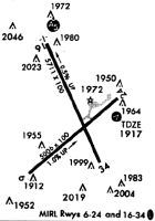
Runway Summary
| Runways: | 06/24 16/34 |
| Longest Runway: | 16/34 is 5711 ft (1741 m) long |
| Runways with an Instrument Approach: |
PSB Airport Runway Details
| Runway 06/24 | 5006 ft x 100 ft (1526 m x 30 m) | |
| Surface: | Asphalt - Poor condition - No special surface treatment | |
| Runway Edge Lights: | Medium Intensity | |
Runway Weight Bearing Capacity (in thousands of pounds) |
||
| Single Wheel Landing Gear: | 48.0 | |
| Dual Wheel Landing Gear: | 60.0 | |
| Dual Tandem Wheel Landing Gear: | 90.0 | |
Runway 06 |
Runway 24 |
|
Elevation: |
1866.9 | 1916.8 |
Latitude: |
40-52-40.2400N | 40-53-12.2310N |
Longitude: |
078-05-39.4640W | 078-04-49.7700W |
|
Runway True Alignment: |
050 | 230 |
Glide Path Angle: |
0.0 degrees | 0.0 degrees |
Traffic Pattern: |
Left | Left |
Runway Markings Type: |
Nonprecision Instrument | Nonprecision Instrument |
Runway Markings Condition: |
Poor | Poor |
Object at End: |
TREES | TREES |
Object Height: |
16 | 35 |
Distance from End: |
353 | 328 |
Object Centerline Offset: |
81 ft. left of centerline | 173 ft. left of centerline |
| Runway 16/34 | 5711 ft x 100 ft (1741 m x 30 m) | |
| Surface: | Asphalt - Poor condition - No special surface treatment | |
| Runway Edge Lights: | Medium Intensity | |
Runway Weight Bearing Capacity (in thousands of pounds) |
||
| Single Wheel Landing Gear: | 48.0 | |
| Dual Wheel Landing Gear: | 60.0 | |
| Dual Tandem Wheel Landing Gear: | 90.0 | |
Runway 16 |
Runway 34 |
|
Elevation: |
1947.8 | 1921.5 |
Latitude: |
40-53-36.2040N | 40-52-44.6280N |
Longitude: |
078-05-29.3650W | 078-04-59.2040W |
|
Runway True Alignment: |
156 | 336 |
Glide Path Angle: |
0.0 degrees | 0.0 degrees |
Traffic Pattern: |
Left | Left |
Runway Markings Type: |
Precision Instrument | Precision Instrument |
Runway Markings Condition: |
Poor | Poor |
Object at End: |
BRUSH | TREES |
Object Height: |
23 | 39 |
Distance from End: |
315 | 549 |
Object Centerline Offset: |
81 ft. left of centerline | 173 ft. left of centerline |
Services
Airframe Repair: |
Major |
Powerplant Repair: |
Major |
Bottled Oxygen: |
None |
Bulk Oxygen: |
None |
Fuel Available: |
80, 100LL |
Landing Fees: |
No |
Parking: |
Tiedowns available |
Maps & Diagrams
PSB Sectional
Flight Planning
at skyvector.com
at skyvector.com