Location
Latitude: |
33-38-11.8000N (33.636611) |
Longitude: |
095-27-02.7000W (-95.45075) |
Elevation: |
547.6 feet MSL (167 m MSL) |
Magnetic Variation: |
1.9 E (as of April 2024 from WMM2020 model) |
Time Zone: |
UTC -6.0 (Standard Time) UTC -5.0 (Daylight Savings Time) |
From City: |
06 N.M. E of Paris, Texas |
Found On: |
Dallas-Ft Worth Chart |
FAA Region: |
ASW |
Contacts
Manager: |
Publicly owned: |
| PAUL STRAHAN 6780 COLLIER DR PARIS, TX 75462 903-784-4648 |
CITY OF PARIS BOX 9037 PARIS, TX 75461 903-784-4648 |
Operations
Airport Status: |
Operational |
Facility Use: |
Public |
Type: |
Airport |
Activation Date: |
08/1943 |
Control tower: |
No |
Attendance (Months/Days/Hours): |
Months/Days/Hours ALL/MON-SAT/0800-1700 |
Boundary ARTCC: |
ZFW (Fort Worth) |
Responsible ARTCC: |
ZFW (Fort Worth) |
Lighting Schedule: |
SEE RMK |
Segmented Circle Indicator: |
Yes |
Traffic Pattern Altitude (MSL): |
1548 feet (472 m) |
NOTAMs Facility: |
PRX |
NOTAM-D Service: |
Yes |
International Airport of Entry: |
No |
Customs Landing Rights: |
No |
Military Landing Rights: |
Yes |
Civil/Military Joint Use: |
No |
Based Aircraft
| Single Engine: | 53 |
| Multi Engine: | 7 |
| Jet Engine: | 4 |
Annual Operations (as of 09/15/2022)
| Total Operations: | 18612 | |
| Air Taxi: | 312 | 1.7% |
| GA Local: | 12775 | 68.6% |
| GA Itinerant: | 5475 | 29.4% |
| Military Aircraft: | 50 | 0.3% |
Communications
| CTAF: | 122.975 |
| Unicom: | 122.975 |
| AWOS-3PT: | 119.675 (903-737-8784) |
- APCH/DEP CTL SVC PRVDD BY FORT WORTH ARTCC (ZFW) ON FREQ 124.875 (DODD CITY/A RCAG).
Fixed Based Operators (FBOs) & Fuel
(Click on a business for detail)
Please help us keep this information up to date. This is a FREE SERVICE just like everything else on Airport Guide! If you see that a business needs to be added, modified, or deleted please fill out our Update Form.
To add, modify, or delete a business click here.
Please help us keep this information up to date. This is a FREE SERVICE just like everything else on Airport Guide! If you see that a business needs to be added, modified, or deleted please fill out our Update Form.
Area Code: 903 |
| Business Name | Frequency | Phone | Fuel Grade |
|---|---|---|---|
| JR Aviation
Update FBO info |
Unicom 122.97 | 784-4648 | 100LL, Jet A |
Flight Service Stations
| Primary | Alternate | |
| FSS on Field: | N | |
| FSS Name (ID): | Fort Worth(FTW) | |
| Frequency: | ||
| Toll Free Phone: | 1-800-WX-BRIEF |
Instrument Procedures / Charts
FAA Terminal Procedures valid from 0901Z 03/21/24 to 0901Z 04/18/24.
There are various types of charts available for an airport. They are listed in the Page Type column. Here is a legend for those types:
APD - Airport Diagram
DP - Departure Procedure Charts
HOT - Hot Spots
IAP - Instrument Approach Procedure Charts
MIN - Minimums
STAR - Standard Terminal Arrival Charts
| Page Type | Page Name | Volume | Action Since Last Cycle |
|---|---|---|---|
| IAP | RNAV (GPS) RWY 17 | SC-2 | |
| IAP | RNAV (GPS) RWY 35 | SC-2 | |
| IAP | VOR RWY 35 | SC-2 | |
| MIN | ALTERNATE MINIMUMS | SC-2 | |
| MIN | TAKEOFF MINIMUMS | SC-2 |
Terminal Procedures are only available for airports in several countries with more being added all the time. If you are looking for a specific country's charts, please send an email to support(at)airportguide.com stating the country name. This will be used to prioritize the implementation.
Navigation Aids (Navaids) near PRX
| Dist (NM) | ID | Morse Code | Name | Type | Freq | True Hdg | Mag Hdg |
|---|---|---|---|---|---|---|---|
| 5.7 | PRX | . _ _ . . _ . _ . . _ | Paris | VOR-DME | 113.60 | 178 | 176 |
| 24.6 | HHW | . . . . . . . . . _ _ | Hugo | NDB | 323 | 349 | 347 |
| 26.7 | SLR | . . . . _ . . . _ . | Sulphur Springs | DME | 109 | 189 | 187 |
| 39.6 | BYP | _ . . . _ . _ _ . _ _ . | Bonham | VORTAC | 114.60 | 261 | 259 |
| 45.6 | UIM | . . _ . . _ _ | Quitman | DME | 114 | 174 | 172 |
| 45.9 | MJF | _ _ . _ _ _ . . _ . | Arvilla | TACAN | 109.60 | 221 | 219 |
| 50.0 | SYW | . . . _ . _ _ . _ _ | Cash | NDB | 428 | 218 | 216 |
| 50.4 | URH | . . _ . _ . . . . . | Texoma | DME | 114.3 | 291 | 289 |
| 53.6 | MII | _ _ . . . . | Caddo Mills | NDB | 316 | 228 | 226 |
| 61.3 | VLY | . . . _ . _ . . _ . _ _ | Melisa | NDB | 421 | 248 | 246 |
| 61.8 | DNI | _ . . _ . . . | Denison | NDB | 341 | 280 | 278 |
| 65.3 | ABG | . _ _ . . . _ _ . | Ambassador | NDB | 404 | 164 | 162 |
| 66.1 | AVZ | . _ . . . _ _ _ . . | Travis | NDB | 260 | 217 | 215 |
| 69.3 | TXK | _ _ . . _ _ . _ | Texarkana | VORTAC | 116.30 | 95 | 94 |
| 70.8 | ATA | . _ _ . _ | Atlanta | NDB | 347 | 116 | 115 |
| 72.0 | ML | _ _ . _ . . | Wampa | NDB | 344 | 345 | 343 |
| 73.3 | TY | _ _ . _ _ | Indoo | NDB | 320 | 180 | 178 |
| 73.4 | PQF | . _ _ . _ _ . _ . . _ . | Mesquite | NDB | 248 | 227 | 225 |
| 74.6 | MLC | _ _ . _ . . _ . _ . | Mc Alester | TACAN | 112.00 | 347 | 345 |
| 75.3 | PGO | . _ _ . _ _ . _ _ _ | Rich Mountain | VORTAC | 113.50 | 33 | 31 |
Nearby Airports with Fuel
Notices to Airmen (NOTAMS)
Remarks
| A110*G | THIS AIRPORT HAS BEEN SURVEYED BY THE NATIONAL GEODETIC SURVEY. |
| A110-1 | RWYS 03/21 & 14/32 NOT AVBL FOR ACR OPNS WITH MORE THAN 30 PSGR SEATS. |
| A110-3 | TWY LGTS FROM TRML APRON TO RWY 17/35 ON MIDFIELD TWY ONLY. |
| A110-4 | RWY 14/32 NO LINE OF SIGHT BTN RWY ENDS. |
| A110-5 | FOR CD IF UNA TO CTC ON FSS FREQ, CTC FORT WORTH ARTCC AT 817-858-7584. |
| A16 | PSTRAHAN@PARISTEXAS.GOV |
| A33-03/21 | RWY COND NOT MNTND. VEGETATION GROWING THROUGH CRACKS. |
| A42-03 | PAVEMENT MKGS FADED. |
| A42-21 | PAVEMENT MKGS FADED. |
| A52-H1 | APPROACH RATIO 5:1; 28 FT TREES 178 FT WEST |
| A58-14 | 10 FT BRUSH, 30 FT DSTC, 244 FT L. |
| A58-17 | 39 FT TREES, 100 FT DSTC, 390 FT L. |
| A58-21 | 40 FT TREES 132 FT DSTC, 245 FT L |
| A58-35 | 20 FT TREES, 0-199 FT DSTC, 250 L. |
| A70-FUEL-10 | 0LL 100LL AVBL 24 HR SELF SERVE. |
| A81-APT | MIRL RWY 17/35 PRESET LOW INTST DUSK-DAWN; TO INCR INTST ACTVT - CTAF. PAPI RWYS 17 & 35 OPRS CONSLY. |
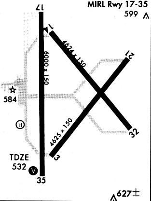
Runways
Runway Summary
| Runways: | 03/21 14/32 17/35 H1 |
| Longest Runway: | 17/35 is 6002 ft (1829 m) long |
| Runways with an Instrument Approach: |
PRX Airport Runway Details
| Runway 03/21 | 4624 ft x 150 ft (1409 m x 46 m) | |
| Runway Length Source: | NGS as of 05/01/2002 | |
| Surface: | Concrete - Poor condition - No special surface treatment | |
Runway Weight Bearing Capacity (in thousands of pounds) |
||
| Single Wheel Landing Gear: | 26.0 | |
Runway 03 |
Runway 21 |
|
Elevation: |
530.3 | 546.2 |
Latitude: |
33-37-49.0036N | 33-38-25.4568N |
Longitude: |
095-27-10.8544W | 095-26-37.8124W |
|
Runway True Alignment: |
037 | 217 |
Glide Path Angle: |
0.0 degrees | 0.0 degrees |
Traffic Pattern: |
Left | Left |
Runway Markings Type: |
Basic | Basic |
Runway Markings Condition: |
Poor | Poor |
Object at End: |
TREES | TREES |
Object Height: |
18 | 40 |
Distance from End: |
201 | 685 |
Object Centerline Offset: |
245 ft. left and right of centerline | 260 ft. left of centerline |
Declared Distances |
||
Take Off Run Avbl. (TORA): |
4624 | 4624 |
Take Off Distance Avbl. (TODA): |
4624 | 4624 |
Actual Stop Dist. Avbl. (ASDA): |
4624 | 4624 |
Landing Dist. Avbl. (LDA): |
4624 | 4624 |
| Runway 14/32 | 4624 ft x 150 ft (1409 m x 46 m) | |
| Runway Length Source: | NGS as of 05/01/2002 | |
| Surface: | Concrete - Poor condition - No special surface treatment | |
Runway Weight Bearing Capacity (in thousands of pounds) |
||
| Single Wheel Landing Gear: | 26.0 | |
Runway 14 |
Runway 32 |
|
Elevation: |
539.5 | 547.3 |
Latitude: |
33-38-34.4312N | 33-37-58.7933N |
Longitude: |
095-27-11.6404W | 095-26-37.3483W |
|
Runway True Alignment: |
141 | 321 |
Glide Path Angle: |
0.0 degrees | 0.0 degrees |
Traffic Pattern: |
Left | Left |
Runway Markings Type: |
Basic | Basic |
Runway Markings Condition: |
Good | Good |
Object at End: |
TREES | |
Object Height: |
30 | |
Distance from End: |
455 | |
Object Centerline Offset: |
245 ft. left and right of centerline | 260 ft. left of centerline |
Declared Distances |
||
Take Off Run Avbl. (TORA): |
4624 | 4624 |
Take Off Distance Avbl. (TODA): |
4624 | 4624 |
Actual Stop Dist. Avbl. (ASDA): |
4624 | 4624 |
Landing Dist. Avbl. (LDA): |
4624 | 4624 |
| Runway 17/35 | 6002 ft x 100 ft (1829 m x 30 m) | |
| Runway Length Source: | NGS as of 05/01/2002 | |
| Surface: | Concrete - Poor condition - No special surface treatment | |
| Runway Edge Lights: | Medium Intensity | |
Runway Weight Bearing Capacity (in thousands of pounds) |
||
| Single Wheel Landing Gear: | 30.0 | |
Runway 17 |
Runway 35 |
|
Elevation: |
541.0 | 526.3 |
Latitude: |
33-38-41.3526N | 33-37-41.9870N |
Longitude: |
095-27-15.9519W | 095-27-14.9310W |
|
Runway True Alignment: |
179 | 359 |
Glide Path Angle: |
3.0 degrees | 3.0 degrees |
Traffic Pattern: |
Left | Left |
Runway Markings Type: |
Nonprecision Instrument | Nonprecision Instrument |
Runway Markings Condition: |
Good | Good |
Object at End: |
TREES | |
Object Height: |
37 | |
Distance from End: |
325 | |
Object Centerline Offset: |
245 ft. left and right of centerline | 260 ft. left of centerline |
Visual Glide Slope Indicators: |
4-Light PAPI On Left Side Of Runway | 4-Light PAPI On Left Side Of Runway |
Threshold Crossing Height: |
40 | 40 |
Declared Distances |
||
Take Off Run Avbl. (TORA): |
6002 | 6002 |
Take Off Distance Avbl. (TODA): |
6002 | 6002 |
Actual Stop Dist. Avbl. (ASDA): |
6002 | 6002 |
Landing Dist. Avbl. (LDA): |
6002 | 6002 |
| Helipad H1 | 40 ft x 40 ft (12 m x 12 m) | |
| Surface: | Concrete - Poor condition - No special surface treatment | |
Helipad H1 |
||
Elevation: |
547.6 | |
Latitude: |
33-38-04.2800N | |
Longitude: |
095-27-23.6200W | |
Glide Path Angle: |
0.0 degrees | 0.0 degrees |
Runway Markings Type: |
None | |
Runway Markings Condition: |
Fair | |
Object Centerline Offset: |
245 ft. left and right of centerline | 260 ft. left of centerline |
Services
Airframe Repair: |
Major |
Powerplant Repair: |
Major |
Fuel Available: |
100LL |
Parking: |
Tiedowns available |
Maps & Diagrams
PRX Sectional
Flight Planning
at skyvector.com
at skyvector.com