Location
Latitude: |
61-57-41.3171N (61.961477) |
Longitude: |
162-56-32.4766W (-162.942354) |
Elevation: |
473.0 feet MSL (144 m MSL) |
Magnetic Variation: |
9.3 E (as of April 2024 from WMM2020 model) |
Time Zone: |
UTC -9.0 (Standard Time) UTC -8.0 (Daylight Savings Time) |
From City: |
03 N.M. NW of Pilot Station, Alaska |
Found On: |
Bethel Chart |
FAA Region: |
AAL |
Contacts
Manager: |
Publicly owned: |
| ERIK WEINGARTH BOX 135 ST MARY'S, AK 99658 907-438-2416 |
ALASKA DOT&PF NORTHERN REGION 2301 PEGER ROAD FAIRBANKS, AK 99709 907-451-2200 |
Operations
Airport Status: |
Operational |
Facility Use: |
Public |
Type: |
Airport |
Activation Date: |
12/1966 |
Control tower: |
No |
Attendance (Months/Days/Hours): |
Months/Days/Hours Unattended |
Boundary ARTCC: |
ZAN (Anchorage) |
Responsible ARTCC: |
ZAN (Anchorage) |
Lighting Schedule: |
SEE RMK |
Segmented Circle Indicator: |
Yes |
Traffic Pattern Altitude (MSL): |
1473 feet (449 m) |
NOTAMs Facility: |
ENA |
NOTAM-D Service: |
Yes |
International Airport of Entry: |
No |
Customs Landing Rights: |
No |
Military Landing Rights: |
Yes |
Civil/Military Joint Use: |
No |
Based Aircraft
Annual Operations (as of 12/31/2022)
| Total Operations: | 700 | |
| Air Taxi: | 500 | 71.4% |
| GA Itinerant: | 200 | 28.6% |
Communications
| CTAF: | 122.900 |
Fixed Based Operators (FBOs) & Fuel
(Click on a business for detail)
Please help us keep this information up to date. This is a FREE SERVICE just like everything else on Airport Guide! If you see that a business needs to be added, modified, or deleted please fill out our Update Form.
To add, modify, or delete a business click here.
Please help us keep this information up to date. This is a FREE SERVICE just like everything else on Airport Guide! If you see that a business needs to be added, modified, or deleted please fill out our Update Form.
Area Code: 907 |
| Business Name | Frequency | Phone | Fuel Grade |
|---|
Flight Service Stations
| Primary | Alternate | |
| FSS on Field: | N | |
| FSS Name (ID): | Kenai(ENA) | |
| Frequency: | ||
| Toll Free Phone: | 1-866-864-1737 |
Instrument Procedures / Charts
Terminal Procedures are only available for airports in several countries with more being added all the time. If you are looking for a specific country's charts, please send an email to support(at)airportguide.com stating the country name. This will be used to prioritize the implementation.
Navigation Aids (Navaids) near PQS
| Dist (NM) | ID | Morse Code | Name | Type | Freq | True Hdg | Mag Hdg |
|---|---|---|---|---|---|---|---|
| 11.2 | SMA | . . . _ _ . _ | St Marys | NDB | 230 | 301 | 292 |
| 65.5 | ENM | . _ . _ _ | Emmonak | VOR-DME | 117.80 | 319 | 310 |
| 76.6 | OSE | _ _ _ . . . . | Oscarville | NDB | 251 | 155 | 145 |
| 77.6 | BET | _ . . . . _ | Bethel | VORTAC | 114.10 | 155 | 145 |
| 86.2 | CZF | _ . _ . _ _ . . . . _ . | Cape Romanzof | NDB | 275 | 264 | 255 |
| 87.0 | ANV | . _ _ . . . . _ | Anvik | NDB | 365 | 60 | 50 |
| 88.4 | CZF | _ . _ . _ _ . . . . _ . | Cape Romanzof | DME | 116.75 | 264 | 255 |
| 94.6 | HPB | . . . . . _ _ . _ . . . | Hooper Bay | VOR-DME | 115.20 | 254 | 245 |
| 97.5 | ANI | . _ _ . . . | Aniak | NDB | 359 | 101 | 91 |
Nearby Airports with Fuel
| Dist (NM) | Name (Airport IDs) | True Hdg | Mag Hdg | Fuel Grade |
|---|---|---|---|---|
| 77.8 | Bethel Airport (BET PABE BET) |
155 | 145 | 100, 100LL, Jet A, Jet A-1 |
| 99.1 | Aniak Airport (ANI PANI ANI) |
101 | 90 | 100LL, Jet A |
Notices to Airmen (NOTAMS)
Remarks
| A110-1 | RY CONDITION NOT MONITORED; RECOMMEND VISUAL INSPECTION PRIOR TO LANDING. |
| A81-APT | ACTVT MIRL RY 04/22 - CTAF. |
| A81-BCN | ACTVT ROTG BCN - CTAF. |
Runways
Runway Summary
| Runways: | 04/22 |
| Longest Runway: | 04/22 is 4000 ft (1219 m) long |
| Runways with an Instrument Approach: |
PQS Airport Runway Details
| Runway 04/22 | 4000 ft x 75 ft (1219 m x 23 m) | |
| Runway Length Source: | 3RD PARTY SURVEY as of 10/04/2019 | |
| Surface: | Gravel/Dirt - Poor condition - No special surface treatment | |
| Runway Edge Lights: | Medium Intensity | |
Runway 04 |
Runway 22 |
|
Elevation: |
452.0 | 472.8 |
Latitude: |
61-57-30.7014N | 61-57-51.9327N |
Longitude: |
162-57-07.7079W | 162-55-57.2452W |
|
Runway True Alignment: |
057 | 237 |
Glide Path Angle: |
0.0 degrees | 0.0 degrees |
Traffic Pattern: |
Left | Left |
Services
Airframe Repair: |
Minor |
Powerplant Repair: |
Minor |
Fuel Available: |
100LL, Jet A |
Landing Fees: |
No |
Parking: |
Tiedowns available |
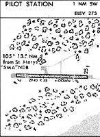
Maps & Diagrams
PQS Sectional
Flight Planning
at skyvector.com
at skyvector.com