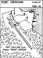
Location
Latitude: |
59-20-54.5100N (59.348475) |
Longitude: |
151-49-49.1600W (-151.830322) |
Elevation: |
93.0 feet MSL (28 m MSL) |
Magnetic Variation: |
14 E (as of April 2024 from WMM2020 model) |
Time Zone: |
UTC -9.0 (Standard Time) UTC -8.0 (Daylight Savings Time) |
From City: |
00 N.M. W of Port Graham, Alaska |
Found On: |
Kodiak Chart |
FAA Region: |
AAL |
Contacts
Manager: |
Publicly owned: |
| KEVIN JONES 2320 KACHEMAK DR HOMER, AK 99603 907-235-5217 |
ALASKA DOT&PF CENTRAL REGION PO BOX 196900 ANCHORAGE, AK 99519-6900 (907) 269-0783 |
Operations
Airport Status: |
Operational |
Facility Use: |
Public |
Type: |
Airport |
Activation Date: |
06/1959 |
Control tower: |
No |
Attendance (Months/Days/Hours): |
Months/Days/Hours Unattended |
Boundary ARTCC: |
ZAN (Anchorage) |
Responsible ARTCC: |
ZAN (Anchorage) |
Segmented Circle Indicator: |
No |
Traffic Pattern Altitude (MSL): |
1093 feet (333 m) |
NOTAMs Facility: |
HOM |
NOTAM-D Service: |
Yes |
International Airport of Entry: |
No |
Customs Landing Rights: |
No |
Military Landing Rights: |
Yes |
Civil/Military Joint Use: |
No |
Based Aircraft
Annual Operations (as of 12/31/2019)
| Total Operations: | 950 | |
| Air Taxi: | 750 | 78.9% |
| GA Itinerant: | 200 | 21.1% |
Communications
| CTAF: | 122.900 |
Fixed Based Operators (FBOs) & Fuel
(Click on a business for detail)
Please help us keep this information up to date. This is a FREE SERVICE just like everything else on Airport Guide! If you see that a business needs to be added, modified, or deleted please fill out our Update Form.
To add, modify, or delete a business click here.
Please help us keep this information up to date. This is a FREE SERVICE just like everything else on Airport Guide! If you see that a business needs to be added, modified, or deleted please fill out our Update Form.
Area Code: 907 |
| Business Name | Frequency | Phone | Fuel Grade |
|---|
Flight Service Stations
| Primary | Alternate | |
| FSS on Field: | N | |
| FSS Name (ID): | Homer(HOM) | Kenai (ENA) |
| Frequency: | ||
| Toll Free Phone: | LC235-8588 | 1-866-864-1737 |
Instrument Procedures / Charts
Terminal Procedures are only available for airports in several countries with more being added all the time. If you are looking for a specific country's charts, please send an email to support(at)airportguide.com stating the country name. This will be used to prioritize the implementation.
Navigation Aids (Navaids) near PGM
| Dist (NM) | ID | Morse Code | Name | Type | Freq | True Hdg | Mag Hdg |
|---|---|---|---|---|---|---|---|
| 20.2 | ACE | . _ _ . _ . . | Kachemak | NDB | 277 | 29 | 15 |
| 24.5 | HOM | . . . . _ _ _ _ _ | Homer | VOR-DME | 114.60 | 27 | 13 |
| 73.4 | OLT | _ _ _ . _ . . _ | Soldotna | NDB-DME | 346 | 22 | 8 |
| 77.3 | IWW | . . . _ _ . _ _ | Wildwood | NDB | 379 | 13 | 359 |
| 78.3 | ENA | . _ . . _ | Kenai | VOR-DME | 117.60 | 13 | 359 |
| 95.7 | RWO | . _ . . _ _ _ _ _ | Woody Island | NDB | 394 | 189 | 175 |
| 95.7 | ODK | _ _ _ _ . . _ . _ | Kodiak | VOR-DME | 117.10 | 189 | 175 |
| 96.6 | ILI | . . . _ . . . . | Iliamna | NDB-DME | 411 | 285 | 272 |
Nearby Airports with Fuel
| Dist (NM) | Name (Airport IDs) | True Hdg | Mag Hdg | Fuel Grade |
|---|---|---|---|---|
| 19.9 | Homer-Beluga Lake Seaplane Base (5BL) |
28 | 14 | 100LL |
| 20.7 | Homer Airport (HOM PAHO HOM) |
30 | 16 | 100LL, Jet A |
| 71.7 | Soldotna Airport (SXQ PASX SXQ) |
19 | 5 | 100LL, Jet A |
| 75.6 | Kenai Municipal Airport (ENA PAEN ENA) |
13 | 359 | 100LL, Jet A |
| 94.3 | Kodiak /Lilly Lake/ Seaplane Base (9Z3) |
190 | 176 | 100LL |
| 97.0 | Iliamna Airport (ILI PAIL ILI) |
285 | 272 | 100LL, Jet A |
Notices to Airmen (NOTAMS)
Remarks
| A110-1 | RY NOT REGULARLY ATNDD BY MAINT PSNL; RECOMMEND VISUAL INSPECTION PRIOR TO USE. |
| A110-10 | TWR .04NM NE OF ARPT UNLGTD. |
| A110-2 | WATCH FOR CHILDREN AND DOGS ON RWY. |
| A110-3 | TREES PENETRATE PART-77 TRANSITIONAL & APCH SURFACES. |
| A110-6 | RY30 DEVELOPS FROST HEAVES FIRST 300 FT & RY12 FIRST 500 FT DURG WINTER. |
| A110-7 | RY DIPS IN CENTER & RY EDGES SOFT DURG SPRING MONTHS. |
| A110-8 | RY EDGES SOFT DURING BREAKUP. |
| A110-9 | ROAD 150 FT FM APCH END OF RY 12. |
| A16 | ALSO 907-235-5217. |
| A33-12/30 | SCATTERED SHARP EDGE ROCKS TO 3 INCHES ON RY. |
| A42-12 | RY 12/30 MKD WITH REFLECTIVE CONES. |
| A52-12 | TOWER (80FT AGL), UNLIGHTED, 59.21.3.90N, 151.49.57.10W, (.03NM NE RW12 THRESHOLD). |
Runways
Runway Summary
| Runways: | 12/30 |
| Longest Runway: | 12/30 is 1975 ft (602 m) long |
| Runways with an Instrument Approach: |
PGM Airport Runway Details
| Runway 12/30 | 1975 ft x 45 ft (602 m x 14 m) | |
| Runway Length Source: | ADO as of 03/11/2014 | |
| Surface: | Gravel/Dirt - Fair condition - No special surface treatment | |
Runway 12 |
Runway 30 |
|
Elevation: |
93.0 | 93.0 |
Latitude: |
59-21-02.4400N | 59-20-46.5800N |
Longitude: |
151-50-00.1600W | 151-49-38.1600W |
|
Runway True Alignment: |
145 | 325 |
Glide Path Angle: |
0.0 degrees | 0.0 degrees |
Traffic Pattern: |
Left | Left |
Object at End: |
BRUSH | BRUSH |
Object Height: |
5 | 15 |
Distance from End: |
0 | 0 |
Object Centerline Offset: |
60 ft. left of centerline | 56 ft. left and right of centerline |
Services
Fuel Available: |
100LL, Jet A |
Parking: |
Tiedowns available |
Maps & Diagrams
PGM Sectional
Flight Planning
at skyvector.com
at skyvector.com