Location
Latitude: |
34-12-02.9050N (34.200807) |
Longitude: |
119-12-26.0150W (-119.207226) |
Elevation: |
44.8 feet MSL (14 m MSL) |
Magnetic Variation: |
11.7 E (as of April 2024 from WMM2020 model) |
Time Zone: |
UTC -8.0 (Standard Time) UTC -7.0 (Daylight Savings Time) |
From City: |
01 N.M. W of Oxnard, California |
Found On: |
Los Angeles Chart |
FAA Region: |
AWP |
Contacts
Manager: |
Publicly owned: |
| KEITH FREITAS 2889 W 5TH ST OXNARD, CA 93030 805-388-4372 |
COUNTY OF VENTURA 555 AIRPORT WAY CAMARILLO, CA 93010 805-388-4372 |
Operations
Airport Status: |
Operational |
Facility Use: |
Public |
Type: |
Airport |
Activation Date: |
04/1942 |
Control tower: |
Yes |
Attendance (Months/Days/Hours): |
Months/Days/Hours ALL/ALL/0500-0030 |
Boundary ARTCC: |
ZLA (Los Angeles) |
Responsible ARTCC: |
ZLA (Los Angeles) |
Lighting Schedule: |
SEE RMK |
Segmented Circle Indicator: |
Yes |
Traffic Pattern Altitude (MSL): |
1045 feet (319 m) |
NOTAMs Facility: |
OXR |
NOTAM-D Service: |
Yes |
International Airport of Entry: |
No |
Customs Landing Rights: |
No |
Military Landing Rights: |
Yes |
Civil/Military Joint Use: |
No |
Aircraft Rescue and Firefighting: |
Class III ARFF Index: A Air Carrier Service: Not Scheduled Certification Date: 05/1973 |
Based Aircraft
| Single Engine: | 89 |
| Multi Engine: | 23 |
| Jet Engine: | 2 |
| GA Helicopters: | 8 |
Annual Operations (as of 09/30/2029)
| Total Operations: | 79975 | |
| Commercial: | 2 | 0.0% |
| Air Taxi: | 4593 | 5.7% |
| GA Local: | 50050 | 62.6% |
| GA Itinerant: | 25059 | 31.3% |
| Military Aircraft: | 271 | 0.3% |
Communications
| CTAF: | 134.950 |
| Tower: | OXNARD 134.95 257.8 Hrs: 0700-2100 |
| Ground: | 121.9 |
| Approach: | POINT MUGU 124.7 124.7 124.7 124.7 L.A. CENTER ARTCC |
| Departure: | POINT MUGU 124.7 124.7 124.7 124.7 L.A. CENTER ARTCC |
| ATIS: | 118.05 Hrs: 24 |
| ASOS: | (805-382-0569) |
- APCH/DEP CTL SVC PRVDD BY LOS ANGELES ARTCC (ZLA) ON FREQ 135.5/327.1.(SANTA BARBARA RCAG) WHEN POINT MAGU APCH CTL (NTD) CLSD.
- ATCT OPER BY BARTON ATC INC.
- FOR AFTR HRS IFR CLNC DEL CTC LOS ANGELES ARTCC 661 575-2052.
Fixed Based Operators (FBOs) & Fuel
(Click on a business for detail)
Please help us keep this information up to date. This is a FREE SERVICE just like everything else on Airport Guide! If you see that a business needs to be added, modified, or deleted please fill out our Update Form.
To add, modify, or delete a business click here.
Please help us keep this information up to date. This is a FREE SERVICE just like everything else on Airport Guide! If you see that a business needs to be added, modified, or deleted please fill out our Update Form.
Area Code: 805 |
| Business Name | Frequency | Phone | Fuel Grade |
|---|---|---|---|
| Aspen Helicopters
Update FBO info |
985-5416 | ||
| Sam's Air Service
Update FBO info |
Unicom 123.5 | 382-1919 | 100LL, Jet A |
Flight Service Stations
| Primary | Alternate | |
| FSS on Field: | N | |
| FSS Name (ID): | Hawthorne(HHR) | |
| Frequency: | ||
| Toll Free Phone: | 1-800-WX-BRIEF |
Instrument Procedures / Charts
FAA Terminal Procedures valid from 0901Z 03/21/24 to 0901Z 04/18/24.
There are various types of charts available for an airport. They are listed in the Page Type column. Here is a legend for those types:
APD - Airport Diagram
DP - Departure Procedure Charts
HOT - Hot Spots
IAP - Instrument Approach Procedure Charts
MIN - Minimums
STAR - Standard Terminal Arrival Charts
| Page Type | Page Name | Volume | Action Since Last Cycle |
|---|---|---|---|
| APD | AIRPORT DIAGRAM | SW-3 | |
| DP | CAMARILLO SIX | SW-3 | |
| DP | SKIFF SEVEN | SW-3 | |
| IAP | ILS OR LOC RWY 25 | SW-3 | |
| IAP | RNAV (GPS) RWY 07 | SW-3 | |
| IAP | RNAV (GPS) RWY 25 | SW-3 | |
| IAP | VOR RWY 25 | SW-3 | |
| MIN | ALTERNATE MINIMUMS | SW-3 | |
| MIN | TAKEOFF MINIMUMS | SW-3 | |
| STAR | GUERA TWO (RNAV) | SW-3 | |
| STAR | GUERA TWO (RNAV)[DELIMITER] CONT.1 | SW-3 |
Terminal Procedures are only available for airports in several countries with more being added all the time. If you are looking for a specific country's charts, please send an email to support(at)airportguide.com stating the country name. This will be used to prioritize the implementation.
Navigation Aids (Navaids) near OXR
| Dist (NM) | ID | Morse Code | Name | Type | Freq | True Hdg | Mag Hdg |
|---|---|---|---|---|---|---|---|
| 5.6 | CMA | _ . _ . _ _ . _ | Camarillo | VOR-DME | 115.80 | 82 | 70 |
| 6.3 | NTD | _ . _ _ . . | Point Mugu | TACAN | 110.60 | 137 | 125 |
| 9.4 | VTU | . . . _ _ . . _ | Ventura | VOR-DME | 108.20 | 123 | 111 |
| 18.7 | FIM | . . _ . . . _ _ | Fillmore | VORTAC | 112.50 | 59 | 47 |
| 33.5 | RZS | . _ . _ _ . . . . . | San Marcus | VORTAC | 114.90 | 303 | 291 |
| 35.5 | VNY | . . . _ _ . _ . _ _ | Van Nuys | VOR-DME | 113.10 | 87 | 75 |
| 39.0 | SMO | . . . _ _ _ _ _ | Santa Monica | VOR-DME | 110.80 | 106 | 94 |
| 39.5 | PAI | . _ _ . . _ . . | Pacoima | NDB | 370 | 84 | 72 |
| 40.0 | GMN | _ _ . _ _ _ . | Gorman | VORTAC | 116.10 | 25 | 13 |
| 41.2 | UR | . . _ . _ . | Vinee | NDB | 253 | 89 | 77 |
| 41.7 | LAX | . _ . . . _ _ . . _ | Los Angeles | VORTAC | 113.60 | 112 | 100 |
| 42.5 | LHS | . _ . . . . . . . . . | Lake Hughes | VORTAC | 114.35 | 46 | 34 |
| 48.1 | GVO | _ _ . . . . _ _ _ _ | Gaviota | VORTAC | 113.80 | 294 | 282 |
| 51.2 | LAX | . _ . . . _ _ . . _ | San Pedro Hill | VOT | 113.90 | 121 | 109 |
| 51.3 | CPM | _ . _ . . _ _ . _ _ | Compton | NDB | 378 | 111 | 99 |
| 58.8 | EMT | . _ _ _ | El Monte | NDB | 359 | 96 | 84 |
| 59.3 | NSI | _ . . . . . . | San Nicolas | TACAN | 110.20 | 192 | 180 |
| 62.2 | PMD | . _ _ . _ _ _ . . | Palmdale | VORTAC | 114.50 | 65 | 53 |
| 62.2 | LG | . _ . . _ _ . | Becca | NDB | 233 | 115 | 103 |
| 62.6 | SLI | . . . . _ . . . . | Seal Beach | VORTAC | 115.70 | 113 | 101 |
Nearby Airports with Fuel
Notices to Airmen (NOTAMS)
Remarks
| A110-1 | NO TOUCH & GO, STOP & GO, OR TAXI BACK OPNS 2000-0700 LCL AFTER THREE CONSECUTIVE PATS, THEN TAXI BACK ONLY. |
| A110-5 | ARPT OPNS LCTD AT BASE OF ATCT; CTC ON 134.95 WHEN ATCT CLSD OR CALL 805-947-6804. |
| A110-6 | FLY FRIENDLY PROCEDURES IN EFCT. AVOID HIGH PWR SETTINGS OVER RESIDENTIAL AREA. KEEP DNWND NORTH OF WOOLEY RD. TURN LEFT CROSSWIND LEG BFR CANAL OR FLY 1/2 MILE PAST SHORELINE. EXP RIGHT TFC RWY 26. SEE VCAIRPORTS.ORG FOR FULL PROC. |
| A110-7 | WILDLIFE ON AND INVOF AIRPORT. |
| A110-8 | ARPT OPNS SUPVR ADDNL CTC DIR OF ARPTS - (805) 388-4200. |
| A14 | ARPT OPNS SUPVR. ADDNL CTC DIR OF ARPTS - KEITH FREITAS 805-388-4200. |
| A23-07 | UPON REQUEST. |
| A24 | |
| A26 | UNSKED ACR OPNS INVOLVING ACFT WITH MORE THAN 9 PAX SEATS ARE NOT AUTHD WO PRIOR COORD WITH ARPT AND CFMN THAT ARFF SVCS ARE AVBL PRIOR TO LDG OR TKOF, CTC 805-947-6804. |
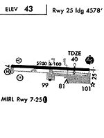
| A57-25 | 45:1 DSPLCD THR. 123 FT AGL SPIRE DSPLCD 200 FT LEFT. |
| A81-APT | WHEN ATCT CLSD, ACTVT MALSF RWY 25, REIL RWY 07, MIRL RWY 07-25 - CTAF. |
| E147 | TPA 1000 AGL SNGL ENG; 1400 AGL MULTI-ENG & JETS. |
Runways
Runway Summary
| Runways: | 07/25 |
| Longest Runway: | 07/25 is 5953 ft (1814 m) long |
| Runways with an Instrument Approach: | 25 |
OXR Airport Runway Details
| Runway 07/25 | 5953 ft x 100 ft (1814 m x 30 m) | |
| Runway Length Source: | 3RD PARTY SURVEY as of 06/12/2018 | |
| Surface: | Asphalt - Fair condition - No special surface treatment | |
| Runway Pavement Class: | 30 /F/D/X/T | |
| Runway Edge Lights: | Medium Intensity | |
Runway Weight Bearing Capacity (in thousands of pounds) |
||
| Single Wheel Landing Gear: | 91.0 | |
| Dual Wheel Landing Gear: | 126.0 | |
| Dual Tandem Wheel Landing Gear: | 174.0 | |
| Dual Dual Tandem Wheel Landing Gear: | 117.0 | |
Runway 07 |
Runway 25 |
|
Elevation: |
33.5 | 44.7 |
Latitude: |
34-12-03.1721N | 34-12-02.6348N |
Longitude: |
119-13-01.4481W | 119-11-50.5820W |
|
Runway True Alignment: |
091 | 271 |
ILS Type: |
ILS | |
Glide Path Angle: |
3.0 degrees | 3.0 degrees |
Traffic Pattern: |
Left | Left |
Runway Markings Type: |
Nonprecision Instrument | Precision Instrument |
Runway Markings Condition: |
Fair | Fair |
Object at End: |
POLE | |
Object Height: |
70 | |
Distance from End: |
2300 | |
Object Centerline Offset: |
210 ft. left of centerline | |
Visual Glide Slope Indicators: |
4-Light PAPI On Right Side Of Runway | 4-Light PAPI On Left Side Of Runway |
Approach Light System: |
1,400 Foot Medium Intensity Approach Lighting System With Sequenced Flashers | |
REIL: |
Yes | |
Touchdown Lights: |
No | No |
Centerline Lights: |
No | No |
Threshold Crossing Height: |
40 | 59 |
Threshold Elevation: |
43.6 | |
Displaced Threshold: |
453 | |
Threshold Latitude: |
34-12-02.6761N | |
Threshold Longitude: |
119-11-55.9741W | |
Declared Distances |
||
Take Off Run Avbl. (TORA): |
5953 | 5953 |
Take Off Distance Avbl. (TODA): |
5953 | 5953 |
Actual Stop Dist. Avbl. (ASDA): |
5654 | 5953 |
Landing Dist. Avbl. (LDA): |
5954 | 5500 |
Services
Airframe Repair: |
Major |
Powerplant Repair: |
Major |
Bulk Oxygen: |
None |
Fuel Available: |
100LL, Jet A |
Landing Fees: |
No |
Parking: |
Tiedowns available |
Maps & Diagrams
OXR Sectional
Flight Planning
at skyvector.com
at skyvector.com