Location
Latitude: |
33-05-24.9000N (33.09025) |
Longitude: |
089-32-31.3000W (-89.542028) |
Elevation: |
494.4 feet MSL (151 m MSL) |
Magnetic Variation: |
2 W (as of April 2024 from WMM2020 model) |
Time Zone: |
UTC -6.0 (Standard Time) UTC -5.0 (Daylight Savings Time) |
From City: |
03 N.M. NE of Kosciusko, Mississippi |
Found On: |
Memphis Chart |
FAA Region: |
ASO |
Contacts
Manager: |
Publicly owned: |
| RICHIE ARMSTRONG 220 W WASHINGTON ST KOSCIUSKO, MS 39090 662-289-1226 |
KOSCIUSKO CITY & ATTALA CO 220 W WASHINGTON ST KOSCIUSKO, MS 39090 662-289-1226 |
Operations
Airport Status: |
Operational |
Facility Use: |
Public |
Type: |
Airport |
Activation Date: |
09/1959 |
Control tower: |
No |
Attendance (Months/Days/Hours): |
Months/Days/Hours Unattended |
Boundary ARTCC: |
ZME (Memphis) |
Responsible ARTCC: |
ZME (Memphis) |
Lighting Schedule: |
SEE RMK |
Segmented Circle Indicator: |
Yes |
Traffic Pattern Altitude (MSL): |
1494 feet (455 m) |
NOTAMs Facility: |
GWO |
NOTAM-D Service: |
Yes |
International Airport of Entry: |
No |
Customs Landing Rights: |
No |
Military Landing Rights: |
Yes |
Civil/Military Joint Use: |
No |
Based Aircraft
| Single Engine: | 8 |
| Multi Engine: | 1 |
| Jet Engine: | 1 |
Annual Operations (as of 03/01/2023)
| Total Operations: | 3245 | |
| GA Local: | 1136 | 35.0% |
| GA Itinerant: | 2083 | 64.2% |
| Military Aircraft: | 26 | 0.8% |
Communications
| CTAF: | 122.900 |
- APCH/DEP SVC PRVDD BY MEMPHIS ARTCC ON FREQS 132.75/263.0 (LOUISVILLE RCAG).
Fixed Based Operators (FBOs) & Fuel
(Click on a business for detail)
Please help us keep this information up to date. This is a FREE SERVICE just like everything else on Airport Guide! If you see that a business needs to be added, modified, or deleted please fill out our Update Form.
To add, modify, or delete a business click here.
Please help us keep this information up to date. This is a FREE SERVICE just like everything else on Airport Guide! If you see that a business needs to be added, modified, or deleted please fill out our Update Form.
Area Code: 601 |
| Business Name | Frequency | Phone | Fuel Grade |
|---|---|---|---|
| Koscuisko-Attala County Airport
Update FBO info |
289-7162, -9845, -3536 | 100LL |
Flight Service Stations
| Primary | Alternate | |
| FSS on Field: | N | |
| FSS Name (ID): | Greenwood(GWO) | |
| Frequency: | ||
| Toll Free Phone: | 1-800-WX-BRIEF |
Instrument Procedures / Charts
FAA Terminal Procedures valid from 0901Z 03/21/24 to 0901Z 04/18/24.
There are various types of charts available for an airport. They are listed in the Page Type column. Here is a legend for those types:
APD - Airport Diagram
DP - Departure Procedure Charts
HOT - Hot Spots
IAP - Instrument Approach Procedure Charts
MIN - Minimums
STAR - Standard Terminal Arrival Charts
| Page Type | Page Name | Volume | Action Since Last Cycle |
|---|---|---|---|
| IAP | RNAV (GPS) RWY 14 | SC-4 | |
| IAP | RNAV (GPS) RWY 32 | SC-4 | |
| MIN | TAKEOFF MINIMUMS | SC-4 |
Terminal Procedures are only available for airports in several countries with more being added all the time. If you are looking for a specific country's charts, please send an email to support(at)airportguide.com stating the country name. This will be used to prioritize the implementation.
Navigation Aids (Navaids) near OSX
| Dist (NM) | ID | Morse Code | Name | Type | Freq | True Hdg | Mag Hdg |
|---|---|---|---|---|---|---|---|
| 40.6 | GW | _ _ . . _ _ | Teock | NDB | 349 | 318 | 320 |
| 43.2 | SQS | . . . _ _ . _ . . . | Sidon | VORTAC | 114.70 | 301 | 303 |
| 47.1 | JAN | . _ _ _ . _ _ . | Jackson | VORTAC | 112.60 | 222 | 224 |
| 48.4 | MHZ | _ _ . . . . _ _ . . | Magnolia | VORTAC | 113.20 | 215 | 217 |
| 50.0 | JA | . _ _ _ . _ | Allen | NDB | 365 | 215 | 217 |
| 50.9 | SBQ | . . . _ . . . _ _ . _ | Scobey | NDB | 245 | 340 | 342 |
| 53.7 | JAN | . _ _ _ . _ _ . | Jackson | VOT | 111.00 | 209 | 211 |
| 54.5 | JH | . _ _ _ . . . . | Brenz | NDB | 260 | 221 | 223 |
| 56.7 | MEI | _ _ . . . | Meridian | VORTAC | 117.00 | 138 | 140 |
| 56.8 | IGB | . . _ _ . _ . . . | Bigbee | VORTAC | 116.20 | 65 | 67 |
| 58.9 | NMM | _ . _ _ _ _ | Meridian | TACAN | 111.90 | 121 | 123 |
| 63.8 | ME | _ _ . | Savoy | NDB | 356 | 142 | 144 |
| 64.4 | CBM | _ . _ . _ . . . _ _ | Caledonia | VORTAC | 115.20 | 58 | 60 |
| 64.6 | RYB | . _ . _ . _ _ _ . . . | Raymond | NDB | 375 | 223 | 225 |
| 69.8 | EWA | . . _ _ . _ | Kewanee | DME | 113.8 | 128 | 130 |
| 75.0 | MTQ | _ _ _ _ _ . _ | Metcalf | NDB | 359 | 285 | 287 |
| 76.0 | TU | _ . . _ | Veron | NDB | 420 | 30 | 32 |
| 76.8 | GLH | _ _ . . _ . . . . . . | Greenville | VOR-DME | 114.25 | 290 | 292 |
| 77.5 | OTB | _ _ _ _ _ . . . | Tupelo | VOR-DME | 109.80 | 28 | 30 |
| 77.8 | UV | . . _ . . . _ | Tunng | NDB | 426 | 356 | 358 |
Nearby Airports with Fuel
Notices to Airmen (NOTAMS)
Remarks
| A110-5 | FOR CD CTC MEMPHIS ARTCC AT 901-368-8453/8449. |
| A110-6 | COURTESY CAR AVBL. |
| A30A-14 | RC MODEL AIRPLANE FLYING OFF RWY END. |
| A70-FUEL-10 | 0LL SELF SVC AVBL 24 HRS VIA CREDIT CARD. |
| A81-APT | ACTVT MIRL RWY 14/32 - CTAF. PAPI RWY 14 & 32 OPR CONSLY. |
Runways
Runway Summary
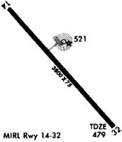
| Runways: | 14/32 |
| Longest Runway: | 14/32 is 5009 ft (1527 m) long |
| Runways with an Instrument Approach: |
OSX Airport Runway Details
| Runway 14/32 | 5009 ft x 75 ft (1527 m x 23 m) | |
| Runway Length Source: | 3RD PARTY SURVEY as of 02/28/2010 | |
| Surface: | Asphalt - Good condition - No special surface treatment | |
| Runway Edge Lights: | Medium Intensity | |
Runway Weight Bearing Capacity (in thousands of pounds) |
||
| Single Wheel Landing Gear: | 18.0 | |
Runway 14 |
Runway 32 |
|
Elevation: |
494.4 | 469.8 |
Latitude: |
33-05-43.1542N | 33-05-06.7110N |
Longitude: |
089-32-51.2165W | 089-32-11.3292W |
|
Runway True Alignment: |
137 | 317 |
Glide Path Angle: |
3.5 degrees | 3.5 degrees |
Traffic Pattern: |
Left | Left |
Runway Markings Type: |
Nonprecision Instrument | Nonprecision Instrument |
Runway Markings Condition: |
Fair | Fair |
Object at End: |
TREES | TREES |
Object Height: |
56 | 46 |
Distance from End: |
1680 | 1175 |
Object Centerline Offset: |
0 ft. left and right of centerline | 40 ft. right of centerline |
Visual Glide Slope Indicators: |
2-Light PAPI On Left Side Of Runway | 2-Light PAPI On Left Side Of Runway |
Threshold Crossing Height: |
38 | 49 |
Services
Powerplant Repair: |
Minor |
Bottled Oxygen: |
None |
Bulk Oxygen: |
None |
Fuel Available: |
100LL, Jet A |
Landing Fees: |
No |
Parking: |
Hangars and tiedowns available |
Maps & Diagrams
OSX Sectional
Flight Planning
at skyvector.com
at skyvector.com