Location
Latitude: |
35-30-25.1070N (35.506974) |
Longitude: |
086-48-13.9950W (-86.803888) |
Elevation: |
718.4 feet MSL (219 m MSL) |
Magnetic Variation: |
4.1 W (as of April 2024 from WMM2020 model) |
Time Zone: |
UTC -6.0 (Standard Time) UTC -5.0 (Daylight Savings Time) |
From City: |
03 N.M. N of Lewisburg, Tennessee |
Found On: |
Atlanta Chart |
FAA Region: |
ASO |
Contacts
Manager: |
Publicly owned: |
| KENT STEWMON 1877 FRANKLIN PIKE LEWISBURG, TN 37091 931-359-5003 |
CITY OF LEWISBURG 131 EAST CHURCH STREET LEWISBURG, TN 37091 931-359-1544 |
Operations
Airport Status: |
Operational |
Facility Use: |
Public |
Type: |
Airport |
Activation Date: |
07/1961 |
Control tower: |
No |
Attendance (Months/Days/Hours): |
Months/Days/Hours ALL/MON-FRI/0800-1700 |
Boundary ARTCC: |
ZME (Memphis) |
Responsible ARTCC: |
ZME (Memphis) |
Lighting Schedule: |
SS-SR |
Segmented Circle Indicator: |
Yes |
Traffic Pattern Altitude (MSL): |
1718 feet (524 m) |
NOTAMs Facility: |
MKL |
NOTAM-D Service: |
Yes |
International Airport of Entry: |
No |
Customs Landing Rights: |
No |
Military Landing Rights: |
Yes |
Civil/Military Joint Use: |
No |
Based Aircraft
| Single Engine: | 42 |
| Multi Engine: | 3 |
| Jet Engine: | 2 |
| GA Helicopters: | 2 |
Annual Operations (as of 07/12/2022)
| Total Operations: | 15050 | |
| GA Local: | 10000 | 66.4% |
| GA Itinerant: | 5000 | 33.2% |
| Military Aircraft: | 50 | 0.3% |
Communications
| CTAF: | 122.800 |
| Unicom: | 122.800 |
| AWOS-3: | 135.775 (931-270-1014) |
- APCH/DEP SVC PRVDD BY MEMPHIS ARTCC ON FREQS 128.15/323.125 (SHELBYVILLE RCAG).
Fixed Based Operators (FBOs) & Fuel
(Click on a business for detail)
Please help us keep this information up to date. This is a FREE SERVICE just like everything else on Airport Guide! If you see that a business needs to be added, modified, or deleted please fill out our Update Form.
To add, modify, or delete a business click here.
Please help us keep this information up to date. This is a FREE SERVICE just like everything else on Airport Guide! If you see that a business needs to be added, modified, or deleted please fill out our Update Form.
Area Code: 931 |
| Business Name | Frequency | Phone | Fuel Grade |
|---|---|---|---|
| Big D Aviation
Update FBO info |
Unicom 122.8 | 359-5003 | 100LL, Jet A |
Flight Service Stations
| Primary | Alternate | |
| FSS on Field: | N | |
| FSS Name (ID): | Jackson(MKL) | |
| Frequency: | ||
| Toll Free Phone: | 1-800-WX-BRIEF |
Instrument Procedures / Charts
FAA Terminal Procedures valid from 0901Z 03/21/24 to 0901Z 04/18/24.
There are various types of charts available for an airport. They are listed in the Page Type column. Here is a legend for those types:
APD - Airport Diagram
DP - Departure Procedure Charts
HOT - Hot Spots
IAP - Instrument Approach Procedure Charts
MIN - Minimums
STAR - Standard Terminal Arrival Charts
| Page Type | Page Name | Volume | Action Since Last Cycle |
|---|---|---|---|
| IAP | RNAV (GPS) RWY 02 | SE-1 | |
| IAP | RNAV (GPS) RWY 20 | SE-1 | |
| MIN | TAKEOFF MINIMUMS | SE-1 |
Terminal Procedures are only available for airports in several countries with more being added all the time. If you are looking for a specific country's charts, please send an email to support(at)airportguide.com stating the country name. This will be used to prioritize the implementation.
Navigation Aids (Navaids) near KLUG
| Dist (NM) | ID | Morse Code | Name | Type | Freq | True Hdg | Mag Hdg |
|---|---|---|---|---|---|---|---|
| 0.5 | LUG | . _ . . . . _ _ _ . | Verona | NDB | 251 | 216 | 220 |
| 15.3 | PBC | . _ _ . _ . . . _ . _ . | Maury County | NDB | 365 | 293 | 297 |
| 16.6 | SYI | . . . _ . _ _ . . | Bomar | FAN MARKER | 94 | 98 | |
| 18.1 | SYI | . . . _ . _ _ . . | Shelbyville | VOR-DME | 113.55 | 79 | 83 |
| 25.8 | TNY | _ _ . _ . _ _ | Kelso | NDB | 358 | 150 | 154 |
| 27.6 | ULH | . . _ . _ . . . . . . | Burwi | NDB | 332 | 95 | 99 |
| 27.7 | LRT | . _ . . . _ . _ | Lawrenceburg | NDB | 269 | 234 | 238 |
| 28.3 | UXM | . . _ _ . . _ _ _ | Tullahoma Regional | VOR | 109.65 | 105 | 109 |
| 31.7 | SWZ | . . . . _ _ _ _ . . | Sewart | NDB | 391 | 31 | 35 |
| 33.3 | MQY | _ _ _ _ . _ _ . _ _ | Smyrna | VOT | 110.20 | 25 | 29 |
| 34.5 | FQW | . . _ . _ _ . _ . _ _ | Walter Hill | NDB | 371 | 37 | 41 |
| 37.1 | BNA | _ . . . _ . . _ | Nashville Metropoln | VOT | 108.60 | 10 | 14 |
| 37.2 | GHM | _ _ . . . . . _ _ | Graham | DME | 111.6 | 302 | 306 |
| 38.2 | BNA | _ . . . _ . . _ | Nashville | VORTAC | 114.10 | 8 | 12 |
| 40.5 | JHG | . _ _ _ . . . . _ _ . | Hohenwald | NDB | 257 | 266 | 270 |
| 41.1 | BGF | _ . . . _ _ . . . _ . | Boiling Fork | NDB | 263 | 118 | 122 |
| 42.5 | VI | . . . _ . . | Opery | NDB | 344 | 9 | 13 |
| 43.4 | RQZ | . _ . _ _ . _ _ _ . . | Rocket | VORTAC | 112.20 | 168 | 172 |
| 44.0 | CWH | _ . _ . . _ _ . . . . | Capshaw | NDB | 350 | 178 | 182 |
| 47.5 | JUE | . _ _ _ . . _ . | Lebanon | NDB | 414 | 29 | 33 |
Nearby Airports with Fuel
Notices to Airmen (NOTAMS)
Remarks
| A110-1 | FOR CD CTC MEMPHIS ARTCC AT 901-368-8453/8449. |
Runways
Runway Summary
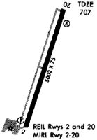
| Runways: | 02/20 |
| Longest Runway: | 02/20 is 5001 ft (1524 m) long |
| Runways with an Instrument Approach: |
KLUG Airport Runway Details
| Runway 02/20 | 5001 ft x 100 ft (1524 m x 30 m) | |
| Runway Length Source: | 3RD PARTY SURVEY as of 08/07/2018 | |
| Surface: | Asphalt - Good condition - No special surface treatment | |
| Runway Pavement Class: | 33 /F/C/X/T | |
| Runway Edge Lights: | Medium Intensity | |
Runway Weight Bearing Capacity (in thousands of pounds) |
||
| Single Wheel Landing Gear: | 28.0 | |
| Dual Wheel Landing Gear: | 41.0 | |
Runway 02 |
Runway 20 |
|
Elevation: |
718.4 | 709.6 |
Latitude: |
35-30-01.6048N | 35-30-48.6084N |
Longitude: |
086-48-23.4120W | 086-48-04.5773W |
|
Runway True Alignment: |
018 | 198 |
Glide Path Angle: |
3.3 degrees | 3.0 degrees |
Traffic Pattern: |
Left | Left |
Runway Markings Type: |
Nonprecision Instrument | Nonprecision Instrument |
Runway Markings Condition: |
Fair | Fair |
Object at End: |
TREES | TREES |
Object Height: |
74 | 74 |
Distance from End: |
1915 | 2095 |
Object Centerline Offset: |
461 ft. left of centerline | 329 ft. right of centerline |
Visual Glide Slope Indicators: |
2-Light PAPI On Left Side Of Runway | 2-Light PAPI On Left Side Of Runway |
REIL: |
Yes | Yes |
Threshold Crossing Height: |
55 | 40 |
Services
Fuel Available: |
100LL, Jet A+, MOGAS |
Landing Fees: |
No |
Parking: |
Hangars and tiedowns available |
Maps & Diagrams
KLUG Sectional
Flight Planning
at skyvector.com
at skyvector.com