Location
Latitude: |
43-21-00.1700N (43.350047) |
Longitude: |
088-23-24.8670W (-88.390241) |
Elevation: |
1070.0 feet MSL (326 m MSL) |
Magnetic Variation: |
3.7 W (as of April 2024 from WMM2020 model) |
Time Zone: |
UTC -6.0 (Standard Time) UTC -5.0 (Daylight Savings Time) |
From City: |
02 N.M. NW of Hartford, Wisconsin |
Found On: |
Chicago Chart |
FAA Region: |
AGL |
Contacts
Manager: |
Publicly owned: |
| DARRYL KRANZ 109 N MAIN HARTFORD, WI 53027 262-673-8225 |
CITY OF HARTFORD 109 N. MAIN HARTFORD, WI 53027 262-673-8263 |
Operations
Airport Status: |
Operational |
Facility Use: |
Public |
Type: |
Airport |
Activation Date: |
06/1978 |
Control tower: |
No |
Attendance (Months/Days/Hours): |
Months/Days/Hours Unattended |
Boundary ARTCC: |
ZAU (Chicago) |
Responsible ARTCC: |
ZAU (Chicago) |
Lighting Schedule: |
SEE RMK |
Segmented Circle Indicator: |
Yes |
Traffic Pattern Altitude (MSL): |
2070 feet (631 m) |
NOTAMs Facility: |
GRB |
NOTAM-D Service: |
Yes |
International Airport of Entry: |
No |
Customs Landing Rights: |
No |
Military Landing Rights: |
Yes |
Civil/Military Joint Use: |
No |
Based Aircraft
| Single Engine: | 75 |
| Multi Engine: | 1 |
| Jet Engine: | 1 |
| GA Helicopters: | 3 |
| Gliders: | 11 |
Annual Operations (as of 08/10/2022)
| Total Operations: | 15500 | |
| Air Taxi: | 400 | 2.6% |
| GA Local: | 10000 | 64.5% |
| GA Itinerant: | 5000 | 32.3% |
| Military Aircraft: | 100 | 0.6% |
Communications
| CTAF: | 123.000 |
| Unicom: | 123.000 |
| Approach: | MILWAUKEE 125.35 125.35 125.35 125.35 |
| Departure: | MILWAUKEE 125.35 125.35 125.35 125.35 |
Fixed Based Operators (FBOs) & Fuel
(Click on a business for detail)
Please help us keep this information up to date. This is a FREE SERVICE just like everything else on Airport Guide! If you see that a business needs to be added, modified, or deleted please fill out our Update Form.
To add, modify, or delete a business click here.
Please help us keep this information up to date. This is a FREE SERVICE just like everything else on Airport Guide! If you see that a business needs to be added, modified, or deleted please fill out our Update Form.
Area Code: 414 |
| Business Name | Frequency | Phone | Fuel Grade |
|---|---|---|---|
| Hartford Aero Enterprises, Inc.
Update FBO info |
Unicom 123.0 | 673-5350 | 100LL |
Flight Service Stations
| Primary | Alternate | |
| FSS on Field: | N | |
| FSS Name (ID): | Green Bay(GRB) | |
| Frequency: | ||
| Toll Free Phone: | 1-800-WX-BRIEF |
Instrument Procedures / Charts
FAA Terminal Procedures valid from 0901Z 03/21/24 to 0901Z 04/18/24.
There are various types of charts available for an airport. They are listed in the Page Type column. Here is a legend for those types:
APD - Airport Diagram
DP - Departure Procedure Charts
HOT - Hot Spots
IAP - Instrument Approach Procedure Charts
MIN - Minimums
STAR - Standard Terminal Arrival Charts
| Page Type | Page Name | Volume | Action Since Last Cycle |
|---|---|---|---|
| DP | ACCRA FIVE (RNAV) | EC-3 | |
| DP | UECKR SIX (RNAV) | EC-3 | |
| IAP | RNAV (GPS) RWY 09 | EC-3 | |
| IAP | RNAV (GPS) RWY 27 | EC-3 | |
| MIN | TAKEOFF MINIMUMS | EC-3 | |
| STAR | GOPAC THREE (RNAV) | EC-3 |
Terminal Procedures are only available for airports in several countries with more being added all the time. If you are looking for a specific country's charts, please send an email to support(at)airportguide.com stating the country name. This will be used to prioritize the implementation.
Navigation Aids (Navaids) near KHXF
| Dist (NM) | ID | Morse Code | Name | Type | Freq | True Hdg | Mag Hdg |
|---|---|---|---|---|---|---|---|
| 12.3 | BJB | _ . . . . _ _ _ _ . . . | West Bend | VOR | 109.80 | 69 | 73 |
| 14.4 | UNU | . . _ _ . . . _ | Juneau | NDB | 344 | 289 | 293 |
| 14.7 | BAE | _ . . . . _ . | Badger | VOR-DME | 116.40 | 161 | 165 |
| 18.1 | RYV | . _ . _ . _ _ . . . _ | Rock River | NDB | 371 | 234 | 238 |
| 21.1 | LJT | . _ . . . _ _ _ _ | Timmerman | DME | 115.65 | 132 | 136 |
| 28.4 | BL | _ . . . . _ . . | Yanks | NDB | 260 | 127 | 131 |
| 30.6 | GM | _ _ . _ _ | Teels | NDB | 242 | 149 | 153 |
| 32.3 | OS | _ _ _ . . . | Pober | NDB | 395 | 347 | 351 |
| 32.4 | MKE | _ _ _ . _ . | Milwaukee | VOT | 109.00 | 137 | 141 |
| 34.4 | FAH | . . _ . . _ . . . . | Falls | DME | 110 | 42 | 46 |
| 39.1 | OSH | _ _ _ . . . . . . . | Oshkosh | VORTAC | 116.75 | 349 | 353 |
| 39.8 | BUU | _ . . . . . _ . . _ | Burbun | DME | 114.5 | 174 | 178 |
| 40.1 | LVV | . _ . . . . . _ . . . _ | Lake Lawn | NDB | 404 | 192 | 196 |
| 43.3 | MSN | _ _ . . . _ . | Madison | VORTAC | 108.60 | 253 | 256 |
| 43.4 | HRK | . . . . . _ . _ . _ | Horlick | DME | 114.05 | 144 | 148 |
| 45.2 | MS | _ _ . . . | Monah | NDB | 400 | 247 | 250 |
| 45.5 | RA | . _ . . _ | Paser | NDB | 206 | 151 | 155 |
| 49.3 | ENW | . _ . . _ _ | Kenosha | DME | 109.2 | 155 | 159 |
| 49.5 | AT | . _ _ | Gamie | NDB | 230 | 350 | 354 |
| 50.0 | EN | . _ . | Codee | NDB | 389 | 161 | 165 |
Nearby Airports with Fuel
Notices to Airmen (NOTAMS)
Remarks
| A110-2 | GLIDER & ULTRALIGHT ACTVTY ON ARPT. |
| A110-5 | (A23) RIGHT TFC PAT ULTRALIGHT & GLIDER ACFT. |
| A110-6 | FOR CD CTC CHICAGO ARTCC AT 630-906-8921. |
| A15 | EMAIL ADDRESS: DKRANZ@HARTFORD.WI.GOV (ALL LOWER CASE). |
| A30A-18 | SLIGHT DOWNHILL SLOPE. |
| A30A-36 | +78 FT WATER TWR 3885 FT FM APCH END. |
| A42-18 | MKD WITH ORANGE & WHITE WOODEN A-FRAMES. |
| A42-36 | MKD WITH ORANGE & WHITE WOODEN A-FRAMES. |
| A70-FUEL-10 | 0LL 24 HR FUEL AVBL WITH CREDIT CARD. |
| A81-APT | ACTVT REIL RWY 9 & 27 - CTAF. MIRL RWY 09/27 PRESET TO LOW SS-SR, TO INCR INTST & ACTVT - CTAF. |
| E147 | TPA: 500 FT AGL ULTRALIGHTS. |
Runways
Runway Summary
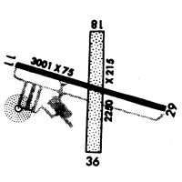
| Runways: | 09/27 18/36 |
| Longest Runway: | 09/27 is 3401 ft (1037 m) long |
| Runways with an Instrument Approach: |
KHXF Airport Runway Details
| Runway 09/27 | 3401 ft x 75 ft (1037 m x 23 m) | |
| Runway Length Source: | 3RD PARTY SURVEY as of 11/11/2019 | |
| Surface: | Asphalt - Excellent condition - No special surface treatment | |
| Runway Edge Lights: | Medium Intensity | |
Runway Weight Bearing Capacity (in thousands of pounds) |
||
| Single Wheel Landing Gear: | 8.0 | |
Runway 09 |
Runway 27 |
|
Elevation: |
1050.6 | 1070.0 |
Latitude: |
43-21-02.4141N | 43-21-01.7653N |
Longitude: |
088-23-45.7210W | 088-22-59.7102W |
|
Runway True Alignment: |
091 | 271 |
Glide Path Angle: |
3.0 degrees | 3.0 degrees |
Traffic Pattern: |
Left | Left |
Runway Markings Type: |
Nonprecision Instrument | Nonprecision Instrument |
Runway Markings Condition: |
Good | Good |
Visual Glide Slope Indicators: |
4-Light PAPI On Left Side Of Runway | 4-Light PAPI On Left Side Of Runway |
REIL: |
Yes | Yes |
Touchdown Lights: |
No | No |
Centerline Lights: |
No | No |
Threshold Crossing Height: |
40 | 40 |
| Runway 18/36 | 2231 ft x 196 ft (680 m x 60 m) | |
| Runway Length Source: | 3RD PARTY SURVEY as of 11/11/2019 | |
| Surface: | Asphalt - Excellent condition - No special surface treatment | |
Runway 18 |
Runway 36 |
|
Elevation: |
1069.5 | 1035.8 |
Latitude: |
43-21-08.2167N | 43-20-46.2654N |
Longitude: |
088-23-26.9016W | 088-23-29.3918W |
|
Runway True Alignment: |
185 | 005 |
Glide Path Angle: |
0.0 degrees | 0.0 degrees |
Traffic Pattern: |
Left | Left |
REIL: |
No | No |
Touchdown Lights: |
No | No |
Centerline Lights: |
No | No |
Services
Airframe Repair: |
None |
Powerplant Repair: |
None |
Bottled Oxygen: |
None |
Bulk Oxygen: |
None |
Fuel Available: |
100LL, Jet A |
Parking: |
Tiedowns available |
Maps & Diagrams
KHXF Sectional
Flight Planning
at skyvector.com
at skyvector.com