Location
Latitude: |
40-47-46.0885N (40.796136) |
Longitude: |
073-06-02.3942W (-73.100665) |
Elevation: |
98.7 feet MSL (30 m MSL) |
Magnetic Variation: |
13 W (as of April 2024 from WMM2020 model) |
Time Zone: |
UTC -5.0 (Standard Time) UTC -4.0 (Daylight Savings Time) |
From City: |
40 N.M. E of New York, New York |
Found On: |
New York Chart |
FAA Region: |
AEA |
Contacts
Manager: |
Publicly owned: |
| SHELLEY LAROSE-ARKEN 100 ARRIVAL AVE RONKONKOMA, NY 11779-7398 631-467-3300 |
TOWN OF ISLIP 655 MAIN ST ISLIP, NY 11751 631-467-3300 |
Operations
Airport Status: |
Operational |
Facility Use: |
Public |
Type: |
Airport |
Activation Date: |
05/1943 |
Control tower: |
Yes |
Attendance (Months/Days/Hours): |
Months/Days/Hours ALL/ALL/ALL |
Boundary ARTCC: |
ZNY (New York) |
Responsible ARTCC: |
ZNY (New York) |
Lighting Schedule: |
SEE RMK |
Segmented Circle Indicator: |
Yes |
Traffic Pattern Altitude (MSL): |
1099 feet (335 m) |
NOTAMs Facility: |
ISP |
NOTAM-D Service: |
Yes |
International Airport of Entry: |
No |
Customs Landing Rights: |
Yes |
Military Landing Rights: |
Yes |
Civil/Military Joint Use: |
No |
Aircraft Rescue and Firefighting: |
Class I ARFF Index: C Air Carrier Service: Scheduled Certification Date: 05/1973 |
Based Aircraft
| Single Engine: | 155 |
| Multi Engine: | 20 |
| Jet Engine: | 53 |
| GA Helicopters: | 36 |
| Military Aircraft: | 9 |
Annual Operations (as of 12/31/2022)
| Total Operations: | 161519 | |
| Commercial: | 8856 | 5.5% |
| Air Taxi: | 6643 | 4.1% |
| GA Local: | 93464 | 57.9% |
| GA Itinerant: | 50450 | 31.2% |
| Military Aircraft: | 2106 | 1.3% |
Communications
| CTAF: | 119.300 |
| Unicom: | 122.950 |
| Tower: | LONG ISLAND 119.3 335.5 124.3 239.3 Hrs: 0600-2400 |
| Clearance Del.: | 121.85 |
| Ground: | 135.3 |
| Approach: | NEW YORK |
| Departure: | NEW YORK |
| ATIS: | 120.725 Hrs: 24 |
| ASOS: | 120.725 (631-471-0131) |
| ARNG OPS: | 45.0 |
| EMERG: | 121.5 |
| EMERG: | 243.0 |
- CLASS C HRS SAME AS ATCT HRS.
Fixed Based Operators (FBOs) & Fuel
(Click on a business for detail)
Please help us keep this information up to date. This is a FREE SERVICE just like everything else on Airport Guide! If you see that a business needs to be added, modified, or deleted please fill out our Update Form.
To add, modify, or delete a business click here.
Please help us keep this information up to date. This is a FREE SERVICE just like everything else on Airport Guide! If you see that a business needs to be added, modified, or deleted please fill out our Update Form.
Area Code: 631 |
| Business Name | Frequency | Phone | Fuel Grade |
|---|---|---|---|
| Liberty Jet Management
Website Update FBO info |
+1-800-879-2345 |
Flight Service Stations
| Primary | Alternate | |
| FSS on Field: | N | |
| FSS Name (ID): | New York(ISP) | |
| Frequency: | ||
| Toll Free Phone: | 1-800-WX-BRIEF |
Instrument Procedures / Charts
FAA Terminal Procedures valid from 0901Z 03/21/24 to 0901Z 04/18/24.
There are various types of charts available for an airport. They are listed in the Page Type column. Here is a legend for those types:
APD - Airport Diagram
DP - Departure Procedure Charts
HOT - Hot Spots
IAP - Instrument Approach Procedure Charts
MIN - Minimums
STAR - Standard Terminal Arrival Charts
| Page Type | Page Name | Volume | Action Since Last Cycle |
|---|---|---|---|
| APD | AIRPORT DIAGRAM | NE-2 | |
| DP | LONG ISLAND SEVEN | NE-2 | |
| HOT | HOT SPOT | NE-2 | |
| IAP | ILS OR LOC RWY 06 | NE-2 | |
| IAP | ILS OR LOC RWY 24 | NE-2 | |
| IAP | ILS RWY 06 (SA CAT I - II) | NE-2 | |
| IAP | RNAV (GPS) RWY 06 | NE-2 | |
| IAP | RNAV (GPS) RWY 15R | NE-2 | |
| IAP | RNAV (GPS) RWY 24 | NE-2 | |
| IAP | RNAV (GPS) RWY 33L | NE-2 | |
| LAH | LAHSO | NE-2 | |
| MIN | ALTERNATE MINIMUMS | NE-2 | |
| MIN | TAKEOFF MINIMUMS | NE-2 | |
| STAR | LOVES TWO | NE-2 | |
| STAR | NELIE THREE (RNAV) | NE-2 |
Terminal Procedures are only available for airports in several countries with more being added all the time. If you are looking for a specific country's charts, please send an email to support(at)airportguide.com stating the country name. This will be used to prioritize the implementation.
Navigation Aids (Navaids) near ISP
| Dist (NM) | ID | Morse Code | Name | Type | Freq | True Hdg | Mag Hdg |
|---|---|---|---|---|---|---|---|
| 0.4 | ISP | . . . . . . _ _ . | Long Island Mac Arthur | VOT | 109.40 | 191 | 204 |
| 5.7 | IS | . . . . . | Lokks | NDB | 366 | 225 | 238 |
| 9.2 | DPK | _ . . . _ _ . _ . _ | Deer Park | VOR-DME | 117.70 | 268 | 281 |
| 10.9 | OP | _ _ _ . _ _ . | Old Field Point Light | NDB | 316 | 355 | 368 |
| 14.9 | BBN | _ . . . _ . . . _ . | Babylon | NDB | 275 | 240 | 253 |
| 15.9 | CCC | _ . _ . _ . _ . _ . _ . | Calverton | VOR-DME | 114.55 | 59 | 72 |
| 17.4 | FR | . . _ . . _ . | Frikk | NDB | 407 | 266 | 279 |
| 21.4 | FOK | . . _ . _ _ _ _ . _ | Suffolk Co | TACAN | 111.00 | 83 | 96 |
| 21.9 | BDR | _ . . . _ . . . _ . | Bridgeport | VOR-DME | 108.80 | 357 | 370 |
| 21.9 | BDR | _ . . . _ . . . _ . | Bridgeport | VOT | 109.25 | 357 | 370 |
| 25.5 | FO | . . _ . _ _ _ | Squir | NDB | 400 | 75 | 88 |
| 29.6 | HVN | . . . . . . . _ _ . | New Haven | DME | 109.8 | 19 | 32 |
| 32.0 | JFK | . _ _ _ . . _ . _ . _ | Kennedy | VOR-DME | 115.90 | 252 | 265 |
| 34.9 | LGA | . _ . . _ _ . . _ | La Guardia | VOR-DME | 113.10 | 269 | 282 |
| 35.2 | JWE | . _ _ _ . _ _ . | Clera | NDB | 362 | 359 | 372 |
| 36.1 | MAD | _ _ . _ _ . . | Madison | VOR-DME | 110.40 | 30 | 43 |
| 36.3 | CMK | _ . _ . _ _ _ . _ | Carmel | VOR-DME | 116.60 | 323 | 336 |
| 36.3 | HTO | . . . . _ _ _ _ | Hampton | VORTAC | 113.60 | 78 | 91 |
| 37.7 | CRI | _ . _ . . _ . . . | Canarsie | VOR-DME | 112.30 | 253 | 266 |
| 38.1 | OGY | _ _ _ _ _ . _ . _ _ | Bridge | NDB | 414 | 249 | 262 |
Nearby Airports with Fuel
Notices to Airmen (NOTAMS)
Remarks
| A110-1 | ADZY:TFC LNDG RWY 33L HIGH DENSITY VFR TFC OPERG 600 FT MSL & BLW VCNTY BAYPORT AERODROME 3 MILES SE. |
| A110-10 | FOR CD WHEN ATCT CLSD CTC NEW YORK APCH AT 516-683-2449. |
| A110-11 | RWY 15L/33R CLSD TO SKED ACR OPS MORE THAN 9 PAX SEATS AND NON SKED ACR OPS MORE THAN 30 PAX SEATS. |
| A110-2 | BIRD ACTVTY ON & INVOF ARPT. |
| A110-3 | TWY S UNLGTD EAST OF TRML APN. |
| A110-4 | RWY 15L/33R CLSD TO FIXED WING ACFT AT NGT & AVBL FOR TXG. |
| A110-7 | UPDRAFTS MAY BE ENCOUNTERED INVOF POWER PLANT 1.5 NM NE RWY 24. |
| A110-8 | RWY 15L/33R NOT AVBL FOR NIGHT TKOF AND LDG OPS. LIMITED TO ACFT 48,000 LBS OR LESS. |
| A110-9 | VOLUNTARY NS ABTMT PROCEDURES IN EFFECT FOR FIXED WING ACFT AND HELICOPTERS. CTC AIRPORT MANAGEMENT (631)467-3300. |
| A24 | LDG FEE FOR ALL ACFT EXC MIL AND GOVT. |
| A30-H1 | LCTD ON TWY W SOUTH OF INT OF TWY B. |
| A30-H2 | LCTD ON TWY C NORTH OF TWY S. |
| A42-15L | NSTD MKGS, THR BAR MISG ON RWY END. |
| A42-33R | NSTD MKGS, THR BAR MISG ON RWY END. |
| A49-06 | NSTD MALSR; THREE OUTERMOST FLASHER LGTS EXCEED STD SPACING. |
| A81-APT | DUSK TO DAWN. WHEN ATCT CLSD ACTVT MIRL RWY 15R/33L; TWY LGTS- CTAF. HIRL RWY 06/24 PRESET LOW INTST ACTVT - CTAF; MALSR RWY 06 & 24 PRESET MED INTST FOR PREVAILING WIND RWY. |
| E80 | LDG FEE FOR ALL ACFT EXC MIL, GOVT AND NOT-FOR-PROFIT MEDICAL FLIGHTS. |
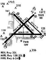
Runways
Runway Summary
| Runways: | 06/24 15L/33R 15R/33L H1 H2 |
| Longest Runway: | 06/24 is 7006 ft (2135 m) long |
| Runways with an Instrument Approach: | 06, 24 |
ISP Heliport Runway Details
| Runway 06/24 | 7006 ft x 150 ft (2135 m x 46 m) | |
| Runway Length Source: | 3RD PARTY SURVEY as of 06/30/2011 | |
| Surface: | Asphalt - Excellent condition - Saw-cut or plastic grooved | |
| Runway Pavement Class: | 55 /F/B/X/U | |
| Runway Edge Lights: | High Intensity | |
Runway Weight Bearing Capacity (in thousands of pounds) |
||
| Single Wheel Landing Gear: | 100.0 | |
| Dual Wheel Landing Gear: | 210.0 | |
| Dual Tandem Wheel Landing Gear: | 300.0 | |
Runway 06 |
Runway 24 |
|
Elevation: |
92.3 | 98.7 |
Latitude: |
40-47-19.0902N | 40-48-08.0453N |
Longitude: |
073-06-44.8159W | 073-05-40.4068W |
|
Runway True Alignment: |
045 | 225 |
ILS Type: |
ILS/DME | ILS |
Glide Path Angle: |
3.0 degrees | 3.0 degrees |
Traffic Pattern: |
Left | Right |
Runway Markings Type: |
Precision Instrument | Precision Instrument |
Runway Markings Condition: |
Good | Good |
Object at End: |
TREE | |
Object Height: |
38 | |
Distance from End: |
1340 | |
Object Centerline Offset: |
350 ft. left of centerline | |
Visual Glide Slope Indicators: |
4-Light PAPI On Left Side Of Runway | 4-Light PAPI On Left Side Of Runway |
Runway Visual Range (RVR): |
Touchdown, Rollout | Touchdown, Rollout |
Approach Light System: |
1,400 Foot Medium Intensity Approach Lighting System With Runway Alignment Indicator Lights | 1,400 Foot Medium Intensity Approach Lighting System With Runway Alignment Indicator Lights |
Touchdown Lights: |
No | |
Centerline Lights: |
Yes | Yes |
Threshold Crossing Height: |
53 | 52 |
Declared Distances |
||
Take Off Run Avbl. (TORA): |
7006 | 7006 |
Take Off Distance Avbl. (TODA): |
7006 | 7006 |
Actual Stop Dist. Avbl. (ASDA): |
7006 | 7006 |
Landing Dist. Avbl. (LDA): |
7006 | 7006 |
| Runway 15L/33R | 3175 ft x 75 ft (968 m x 23 m) | |
| Runway Length Source: | 3RD PARTY SURVEY as of 06/30/2011 | |
| Surface: | Asphalt - Excellent condition - No special surface treatment | |
| Runway Pavement Class: | 19 /F/B/X/U | |
Runway Weight Bearing Capacity (in thousands of pounds) |
||
| Single Wheel Landing Gear: | 25.0 | |
Runway 15L |
Runway 33R |
|
Elevation: |
91.2 | 81.4 |
Latitude: |
40-47-56.5234N | 40-47-34.3411N |
Longitude: |
073-05-54.1792W | 073-05-24.9865W |
|
Runway True Alignment: |
135 | 315 |
Glide Path Angle: |
0.0 degrees | 0.0 degrees |
Traffic Pattern: |
Left | Right |
Runway Markings Type: |
Nonstandard (other than numbers only) | Nonstandard (other than numbers only) |
Runway Markings Condition: |
Good | Good |
Object Centerline Offset: |
350 ft. left of centerline | |
Declared Distances |
||
Take Off Run Avbl. (TORA): |
3175 | 3175 |
Take Off Distance Avbl. (TODA): |
3175 | 3175 |
Actual Stop Dist. Avbl. (ASDA): |
3175 | 3175 |
Landing Dist. Avbl. (LDA): |
3175 | 3175 |
| Runway 15R/33L | 5186 ft x 150 ft (1581 m x 46 m) | |
| Runway Length Source: | 3RD PARTY SURVEY as of 06/30/2011 | |
| Surface: | Asphalt - Excellent condition - Saw-cut or plastic grooved | |
| Runway Pavement Class: | 55 /F/B/X/U | |
| Runway Edge Lights: | Medium Intensity | |
Runway Weight Bearing Capacity (in thousands of pounds) |
||
| Single Wheel Landing Gear: | 100.0 | |
| Dual Wheel Landing Gear: | 170.0 | |
| Dual Tandem Wheel Landing Gear: | 300.0 | |
Runway 15R |
Runway 33L |
|
Elevation: |
98.5 | 78.5 |
Latitude: |
40-48-08.0173N | 40-47-31.7742N |
Longitude: |
073-06-26.3880W | 073-05-38.7259W |
|
Runway True Alignment: |
135 | 315 |
Glide Path Angle: |
3.1 degrees | 3.0 degrees |
Traffic Pattern: |
Right | Left |
Runway Markings Type: |
Nonprecision Instrument | Nonprecision Instrument |
Runway Markings Condition: |
Good | Good |
Object at End: |
TREES | |
Object Height: |
39 | |
Distance from End: |
1300 | |
Object Centerline Offset: |
350 ft. left of centerline | |
Visual Glide Slope Indicators: |
4-Light PAPI On Left Side Of Runway | 4-Light PAPI On Left Side Of Runway |
Threshold Crossing Height: |
46 | 50 |
Declared Distances |
||
Take Off Run Avbl. (TORA): |
5186 | 5186 |
Take Off Distance Avbl. (TODA): |
5186 | 5186 |
Actual Stop Dist. Avbl. (ASDA): |
5186 | 5186 |
Landing Dist. Avbl. (LDA): |
5186 | 5186 |
| Helipad H1 | 50 ft x 50 ft (15 m x 15 m) | |
| Runway Length Source: | OWNER as of 07/23/2021 | |
| Surface: | Asphalt - Excellent condition - No special surface treatment | |
Helipad H1 |
||
Elevation: |
94.0 | |
Latitude: |
40-47-55.8127N | |
Longitude: |
073-06-25.9451W | |
Glide Path Angle: |
0.0 degrees | 0.0 degrees |
Runway Markings Type: |
Basic | |
Runway Markings Condition: |
Good | |
Object Centerline Offset: |
350 ft. left of centerline |
| Helipad H2 | 50 ft x 50 ft (15 m x 15 m) | |
| Runway Length Source: | OWNER as of 07/23/2021 | |
| Surface: | Asphalt - Excellent condition - No special surface treatment | |
Helipad H2 |
||
Elevation: |
80.5 | |
Latitude: |
40-47-29.8771N | |
Longitude: |
073-06-03.3606W | |
Glide Path Angle: |
0.0 degrees | 0.0 degrees |
Runway Markings Type: |
Basic | |
Runway Markings Condition: |
Good | |
Object Centerline Offset: |
350 ft. left of centerline |
Services
Airframe Repair: |
None |
Fuel Available: |
Jet A |
Parking: |
Hangars available |
Maps & Diagrams

ISP Sectional
Flight Planning
at skyvector.com
at skyvector.com