Location
Latitude: |
32-13-28.1820N (32.224495) |
Longitude: |
080-41-50.6430W (-80.697401) |
Elevation: |
19.4 feet MSL (6 m MSL) |
Magnetic Variation: |
7.7 W (as of April 2024 from WMM2020 model) |
Time Zone: |
UTC -5.0 (Standard Time) UTC -4.0 (Daylight Savings Time) |
From City: |
03 N.M. E of Hilton Head Island, South Carolina |
Found On: |
Charlotte Chart |
FAA Region: |
ASO |
Contacts
Manager: |
Publicly owned: |
| JON REMBOLD 120 BEACH CITY ROAD HILTON HEAD ISLAND, SC 29926 843-255-2952 |
BEAUFORT COUNTY 120 BEACH CITY ROAD HILTON HEAD ISLAND, SC 29926 843-255-2950 |
Operations
Airport Status: |
Operational |
Facility Use: |
Public |
Type: |
Airport |
Control tower: |
Yes |
Attendance (Months/Days/Hours): |
Months/Days/Hours ALL/ALL/0600-2200 |
Boundary ARTCC: |
ZJX (Jacksonville) |
Responsible ARTCC: |
ZJX (Jacksonville) |
Lighting Schedule: |
SEE RMK |
Segmented Circle Indicator: |
Yes |
Traffic Pattern Altitude (MSL): |
1019 feet (311 m) |
NOTAMs Facility: |
HXD |
NOTAM-D Service: |
Yes |
International Airport of Entry: |
No |
Customs Landing Rights: |
No |
Military Landing Rights: |
Yes |
Civil/Military Joint Use: |
No |
Aircraft Rescue and Firefighting: |
Class I ARFF Index: B Air Carrier Service: Scheduled Certification Date: 06/1982 |
Based Aircraft
| Single Engine: | 55 |
| Multi Engine: | 23 |
| Jet Engine: | 8 |
| GA Helicopters: | 2 |
Annual Operations (as of 07/31/2023)
| Total Operations: | 39550 | |
| Commercial: | 3821 | 9.7% |
| Air Taxi: | 5599 | 14.2% |
| GA Local: | 2769 | 7.0% |
| GA Itinerant: | 26274 | 66.4% |
| Military Aircraft: | 1087 | 2.7% |
Communications
| CTAF: | 118.975 |
| Tower: | HILTON HEAD 118.975 Hrs: 0700-2100 |
| Clearance Del.: | 121.1 121.1 121.1 121.1 |
| Ground: | 121.1 |
| Approach: | SAVANNAH JAX ARTCC |
| Departure: | SAVANNAH JAX ARTCC |
| ATIS: | 121.4 Hrs: 24 |
| AWOS-3P: | 121.4 (843-342-5072) |
- APCH/DEP SVC PRVDD BY JACKSONVILLE ARTCC ON FREQS 132.925/363.2 (SAVANNAH RCAG) WHEN SAVANNAH APCH CTL CLSD.
Fixed Based Operators (FBOs) & Fuel
(Click on a business for detail)
Please help us keep this information up to date. This is a FREE SERVICE just like everything else on Airport Guide! If you see that a business needs to be added, modified, or deleted please fill out our Update Form.
To add, modify, or delete a business click here.
Please help us keep this information up to date. This is a FREE SERVICE just like everything else on Airport Guide! If you see that a business needs to be added, modified, or deleted please fill out our Update Form.
Area Code: 843 |
| Business Name | Frequency | Phone | Fuel Grade |
|---|---|---|---|
| Carolina Air Center
Update FBO info |
689-3200 | 100LL, Jet A | |
| Hilton Head Air Service, Inc.
Update FBO info |
Unicom 123.0 | 681-6386, 888-681-6386 | 100LL, Jet A |
| Signature Flight Support
Update FBO info |
Unicom: 118.98, Arinc: 128.875 | +1 843 689 3200 | |
| South Carolina Air Transport
Update FBO info |
681-9119, 800-737-4767 | 100LL, Jet A |
Flight Service Stations
| Primary | Alternate | |
| FSS on Field: | N | |
| FSS Name (ID): | Anderson(AND) | |
| Frequency: | ||
| Toll Free Phone: | 1-800-WX-BRIEF |
Instrument Procedures / Charts
FAA Terminal Procedures valid from 0901Z 03/21/24 to 0901Z 04/18/24.
There are various types of charts available for an airport. They are listed in the Page Type column. Here is a legend for those types:
APD - Airport Diagram
DP - Departure Procedure Charts
HOT - Hot Spots
IAP - Instrument Approach Procedure Charts
MIN - Minimums
STAR - Standard Terminal Arrival Charts
| Page Type | Page Name | Volume | Action Since Last Cycle |
|---|---|---|---|
| APD | AIRPORT DIAGRAM | SE-2 | |
| IAP | BROAD CREEK VISUAL RWY 03 | SE-2 | |
| IAP | LOC RWY 21 | SE-2 | |
| IAP | RNAV (GPS) RWY 03 | SE-2 | |
| IAP | RNAV (GPS) RWY 21 | SE-2 | |
| IAP | VOR-A | SE-2 | |
| MIN | ALTERNATE MINIMUMS | SE-2 | |
| MIN | TAKEOFF MINIMUMS | SE-2 |
Terminal Procedures are only available for airports in several countries with more being added all the time. If you are looking for a specific country's charts, please send an email to support(at)airportguide.com stating the country name. This will be used to prioritize the implementation.
Navigation Aids (Navaids) near HHH
| Dist (NM) | ID | Morse Code | Name | Type | Freq | True Hdg | Mag Hdg |
|---|---|---|---|---|---|---|---|
| 15.3 | NBC | _ . _ . . . _ . _ . | Beaufort | TACAN | 110.50 | 356 | 364 |
| 19.8 | SV | . . . . . . _ | Wassa | NDB | 335 | 228 | 236 |
| 25.9 | SVN | . . . . . . _ _ . | Hunter | VOR-DME | 111.60 | 240 | 248 |
| 25.9 | SAV | . . . . _ . . . _ | Savannah | VORTAC | 115.95 | 259 | 267 |
| 26.3 | SAV | . . . . _ . . . _ | Savannah Travis Fld | VOT | 111.00 | 257 | 265 |
| 32.7 | SA | . . . . _ | Mavis | NDB | 368 | 260 | 268 |
| 42.2 | RBW | . _ . _ . . . . _ _ | Walterboro | NDB | 221 | 3 | 11 |
| 47.6 | MOQ | _ _ _ _ _ _ _ . _ | Mc Intosh | NDB | 263 | 240 | 247 |
| 50.3 | BZ | _ . . . _ _ . . | Bullo | NDB | 407 | 283 | 290 |
| 52.1 | JYL | . _ _ _ _ . _ _ . _ . . | Sylvania | NDB | 245 | 299 | 306 |
| 52.2 | CHS | _ . _ . . . . . . . . | Charleston | VORTAC | 113.50 | 39 | 47 |
| 52.6 | CHS | _ . _ . . . . . . . . | Charleston | VOT | 111.00 | 38 | 46 |
| 54.4 | CH | _ . _ . . . . . | Ashly | NDB | 329 | 33 | 41 |
| 54.5 | DYB | _ . . _ . _ _ _ . . . | Dorchester County | NDB | 365 | 22 | 30 |
| 56.0 | ALD | . _ . _ . . _ . . | Allendale | VOR | 116.70 | 327 | 335 |
| 59.8 | CWV | _ . _ . . _ _ . . . _ | Claxton | NDB | 395 | 268 | 275 |
| 69.0 | BQK | _ . . . _ _ . _ _ . _ | Brunswick | VOT | 111.00 | 214 | 221 |
| 72.8 | JES | . _ _ _ . . . . | Slover | NDB | 340 | 236 | 243 |
| 74.3 | EDS | . _ . . . . . | Edisto | VOR-DME | 111.40 | 353 | 361 |
| 74.6 | RVJ | . _ . . . . _ . _ _ _ | Prison | NDB | 424 | 262 | 269 |
Nearby Airports with Fuel
Notices to Airmen (NOTAMS)
Remarks
| A110-1 | NOISE ABATEMENT PROCS IN EFC, CTC OPS (843) 255-2960. |
| A110-2 | BIRDS ON & INVOF ARPT. |
| A110-3 | PARASAIL OPNS WITHIN 3 NM RADIUS OF SAV 009 DEGS/15 NM, SFC TO 1500 DURG DALGT HRS. |
| A110-6 | DEER ON AND INVOF ARPT. |
| A26 | CLSD TO UNSKED ACR OPNS WITH MORE THAN 30 PSGR SEATS EXCP 24 HRS PPR CALL AMGR (843) 255-2950 |
| A43-03 | PAPI UNUSBL BYD 7 DEGS LEFT OF CNTRLN. |
| A57-21 | 33:1 TO DSPLCD THLD ; TREES AT 1600 FT. |
| A81-APT | ACTVT MIRL 03/21 AND REIL RYS 03 & 21 - CTAF. |
| E60-03 | ENGINEERED MATERIALS ARRESTING SYSTEM (EMAS) 207 FT IN LENGTH BY 105 FT IN WIDTH LCTD AT THE DER 03. |
| E60-21 | ENGINEERED MATERIALS ARRESTING SYSTEM (EMAS) 211 FT IN LENGTH BY 105 FT IN WIDTH LCTD AT THE DER 21. |
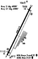
Runways
Runway Summary
| Runways: | 03/21 |
| Longest Runway: | 03/21 is 5000 ft (1524 m) long |
| Runways with an Instrument Approach: | 21 |
HHH Airport Runway Details
| Runway 03/21 | 5000 ft x 100 ft (1524 m x 30 m) | |
| Runway Length Source: | 3RD PARTY SURVEY as of 08/30/2018 | |
| Surface: | Asphalt - Good condition - Saw-cut or plastic grooved | |
| Runway Edge Lights: | Medium Intensity | |
Runway Weight Bearing Capacity (in thousands of pounds) |
||
| Single Wheel Landing Gear: | 55.0 | |
| Dual Wheel Landing Gear: | 75.0 | |
Runway 03 |
Runway 21 |
|
Elevation: |
18.9 | 11.2 |
Latitude: |
32-13-05.9595N | 32-13-50.4048N |
Longitude: |
080-42-03.4282W | 080-41-37.8564W |
|
Runway True Alignment: |
026 | 206 |
ILS Type: |
LOC/DME | |
Glide Path Angle: |
3.0 degrees | 3.0 degrees |
Traffic Pattern: |
Left | Left |
Runway Markings Type: |
Nonprecision Instrument | Nonprecision Instrument |
Runway Markings Condition: |
Good | Good |
Arresting Device: |
EMAS | EMAS |
Object at End: |
TREE | TREE |
Object Height: |
56 | 55 |
Distance from End: |
1325 | 1300 |
Object Centerline Offset: |
250 ft. right of centerline | 225 ft. right of centerline |
Visual Glide Slope Indicators: |
4-Light PAPI On Left Side Of Runway | 4-Light PAPI On Right Side Of Runway |
REIL: |
Yes | Yes |
Threshold Crossing Height: |
40 | 40 |
Threshold Elevation: |
19.1 | 12.3 |
Displaced Threshold: |
297 | 403 |
Threshold Latitude: |
32-13-08.5963N | 32-13-46.8237N |
Threshold Longitude: |
080-42-01.9116W | 080-41-39.9172W |
Declared Distances |
||
Take Off Run Avbl. (TORA): |
5000 | 5000 |
Take Off Distance Avbl. (TODA): |
5000 | 5000 |
Actual Stop Dist. Avbl. (ASDA): |
5000 | 5000 |
Landing Dist. Avbl. (LDA): |
4703 | 4597 |
Services
Airframe Repair: |
Major |
Powerplant Repair: |
Major |
Bottled Oxygen: |
High Pressure |
Fuel Available: |
100LL, Jet A |
Landing Fees: |
No |
Parking: |
Hangars and tiedowns available |
Maps & Diagrams
HHH Sectional
Flight Planning
at skyvector.com
at skyvector.com