Location
Latitude: |
35-51-27.9310N (35.857759) |
Longitude: |
083-31-43.3310W (-83.528703) |
Elevation: |
1013.9 feet MSL (309 m MSL) |
Magnetic Variation: |
6.3 W (as of April 2024 from WMM2020 model) |
Time Zone: |
UTC -5.0 (Standard Time) UTC -4.0 (Daylight Savings Time) |
From City: |
02 N.M. SE of Sevierville, Tennessee |
Found On: |
Atlanta Chart |
FAA Region: |
ASO |
Contacts
Manager: |
Publicly owned: |
| EMILY HAUN 134 AIR MUSEUM WAY SEVIERVILLE, TN 37862 865-453-8393 |
SEVIER COUNTY COURT HOUSE SEVIERVILLE, TN 37862 865-453-6136 |
Operations
Airport Status: |
Operational |
Facility Use: |
Public |
Type: |
Airport |
Activation Date: |
01/1964 |
Control tower: |
No |
Attendance (Months/Days/Hours): |
Months/Days/Hours NOV-FEB/ALL/0800-1800 |
Boundary ARTCC: |
ZTL (Atlanta) |
Responsible ARTCC: |
ZTL (Atlanta) |
Lighting Schedule: |
SEE RMK |
Segmented Circle Indicator: |
Yes |
Traffic Pattern Altitude (MSL): |
2014 feet (614 m) |
NOTAMs Facility: |
BNA |
NOTAM-D Service: |
Yes |
International Airport of Entry: |
No |
Customs Landing Rights: |
No |
Military Landing Rights: |
Yes |
Civil/Military Joint Use: |
No |
Based Aircraft
| Single Engine: | 67 |
| Multi Engine: | 12 |
| Jet Engine: | 6 |
| GA Helicopters: | 5 |
Annual Operations (as of 08/02/2022)
| Total Operations: | 115178 | |
| Air Taxi: | 5253 | 4.6% |
| GA Local: | 48000 | 41.7% |
| GA Itinerant: | 61800 | 53.7% |
| Military Aircraft: | 125 | 0.1% |
Communications
| CTAF: | 123.000 |
| Unicom: | 123.000 |
| Approach: | KNOXVILLE 132.8 132.8 |
| Departure: | KNOXVILLE 132.8 132.8 |
| AWOS-3: | 126.875 (865-429-5401) |
Fixed Based Operators (FBOs) & Fuel
(Click on a business for detail)
Please help us keep this information up to date. This is a FREE SERVICE just like everything else on Airport Guide! If you see that a business needs to be added, modified, or deleted please fill out our Update Form.
To add, modify, or delete a business click here.
Please help us keep this information up to date. This is a FREE SERVICE just like everything else on Airport Guide! If you see that a business needs to be added, modified, or deleted please fill out our Update Form.
Area Code: 865 |
| Business Name | Frequency | Phone | Fuel Grade |
|---|---|---|---|
| Gatlinburg-Pigeon Forge Aviation Center
Update FBO info |
Unicom 123.0 | 453-8393 | 100LL, Jet A |
Flight Service Stations
| Primary | Alternate | |
| FSS on Field: | N | |
| FSS Name (ID): | Nashville(BNA) | |
| Frequency: | ||
| Toll Free Phone: | 1-800-WX-BRIEF |
Instrument Procedures / Charts
FAA Terminal Procedures valid from 0901Z 03/21/24 to 0901Z 04/18/24.
There are various types of charts available for an airport. They are listed in the Page Type column. Here is a legend for those types:
APD - Airport Diagram
DP - Departure Procedure Charts
HOT - Hot Spots
IAP - Instrument Approach Procedure Charts
MIN - Minimums
STAR - Standard Terminal Arrival Charts
| Page Type | Page Name | Volume | Action Since Last Cycle |
|---|---|---|---|
| IAP | RNAV (GPS) RWY 10 | SE-1 | |
| IAP | VOR/DME RWY 10 | SE-1 | |
| MIN | ALTERNATE MINIMUMS | SE-1 | |
| MIN | TAKEOFF MINIMUMS | SE-1 |
Terminal Procedures are only available for airports in several countries with more being added all the time. If you are looking for a specific country's charts, please send an email to support(at)airportguide.com stating the country name. This will be used to prioritize the implementation.
Navigation Aids (Navaids) near GKT
| Dist (NM) | ID | Morse Code | Name | Type | Freq | True Hdg | Mag Hdg |
|---|---|---|---|---|---|---|---|
| 15.4 | JXT | . _ _ _ _ . . _ _ | Jefferson | NDB | 346 | 9 | 15 |
| 18.0 | VXV | . . . _ _ . . _ . . . _ | Volunteer | VORTAC | 116.40 | 279 | 285 |
| 22.9 | TYS | _ _ . _ _ . . . | Knoxville | VOT | 112.00 | 263 | 269 |
| 23.5 | SOT | . . . _ _ _ _ | Snowbird | VORTAC | 108.80 | 99 | 105 |
| 35.2 | DYQ | _ . . _ . _ _ _ _ . _ | Dulaney | NDB | 263 | 61 | 68 |
| 45.7 | MNV | _ _ _ . . . . _ | Madisonville | NDB | 361 | 245 | 251 |
| 47.6 | RVN | . _ . . . . _ _ . | Rogersville | NDB | 329 | 40 | 47 |
| 49.8 | IM | . . _ _ | Keans | NDB | 357 | 112 | 119 |
| 57.5 | MMI | _ _ _ _ . . | Mc Minn County | NDB | 242 | 241 | 247 |
| 58.1 | HRS | . . . . . _ . . . . | Harris | VORTAC | 109.80 | 199 | 205 |
| 59.6 | BO | _ . . . _ _ _ | Booie | NDB | 221 | 56 | 63 |
| 61.5 | BPO | _ . . . . _ _ . _ _ _ | Piney Grove | NDB | 403 | 312 | 318 |
| 62.4 | BRA | _ . . . . _ . . _ | Broad River | NDB | 379 | 123 | 130 |
| 66.9 | EZT | . _ _ . . _ | Elizabethton | NDB | 275 | 65 | 72 |
| 67.2 | SUG | . . . . . _ _ _ . | Sugarloaf Mountain | VORTAC | 112.20 | 113 | 120 |
| 70.6 | ODF | _ _ _ _ . . . . _ . | Foothills | VOR-DME | 113.40 | 170 | 176 |
| 70.7 | HCH | . . . . _ . _ . . . . . | Hinch Mountain | VOR-DME | 117.60 | 266 | 272 |
| 72.0 | DTE | _ . . _ . | Mark Anton | NDB | 394 | 252 | 258 |
| 72.0 | TR | _ . _ . | Mocca | NDB | 299 | 54 | 61 |
| 74.7 | LQK | . _ . . _ _ . _ _ . _ | Lake Keowee | NDB | 408 | 147 | 154 |
Nearby Airports with Fuel
Notices to Airmen (NOTAMS)
Remarks
| A110-1 | DEER ON & INVOF ARPT. |
| A110-3 | FOR CD CTC KNOXVILLE APCH AT 865-980-3034; IF UNA FOR CD CTC KNOXVILLE APCH AT 865-980-3033. |
| A30A-10 | PAEW NW SIDE. |
| A57-28 | APCH RATIO 26:1 TO DSPLCD THR. |
| A81-APT | MIRL RY 10/28 PRESET LOW INTST; TO INCREASE INTST ACTVT - CTAF. PAPI RYS 10 & 28 OPER CONT. |
Runways
Runway Summary
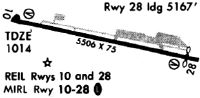
| Runways: | 10/28 |
| Longest Runway: | 10/28 is 5506 ft (1678 m) long |
| Runways with an Instrument Approach: |
GKT Airport Runway Details
| Runway 10/28 | 5506 ft x 75 ft (1678 m x 23 m) | |
| Runway Length Source: | 3RD PARTY SURVEY as of 10/08/2016 | |
| Surface: | Asphalt - Good condition - No special surface treatment | |
| Runway Edge Lights: | Medium Intensity | |
Runway Weight Bearing Capacity (in thousands of pounds) |
||
| Single Wheel Landing Gear: | 40.0 | |
| Dual Wheel Landing Gear: | 54.0 | |
Runway 10 |
Runway 28 |
|
Elevation: |
1013.9 | 1006.1 |
Latitude: |
35-51-32.0933N | 35-51-23.7661N |
Longitude: |
083-32-16.3792W | 083-31-10.2845W |
|
Runway True Alignment: |
099 | 279 |
Glide Path Angle: |
3.5 degrees | 4.5 degrees |
Traffic Pattern: |
Left | Left |
Runway Markings Type: |
Nonprecision Instrument | Nonprecision Instrument |
Runway Markings Condition: |
Good | Good |
Object at End: |
TREE | |
Object Height: |
51 | |
Distance from End: |
1071 | |
Object Centerline Offset: |
168 ft. left of centerline | |
Visual Glide Slope Indicators: |
4-Light PAPI On Left Side Of Runway | 4-Light PAPI On Left Side Of Runway |
REIL: |
Yes | Yes |
Threshold Crossing Height: |
33 | 41 |
Threshold Elevation: |
1002.7 | |
Displaced Threshold: |
350 | |
Threshold Latitude: |
35-51-24.2968N | |
Threshold Longitude: |
083-31-14.4872W |
Services
Airframe Repair: |
Major |
Powerplant Repair: |
Major |
Bottled Oxygen: |
None |
Bulk Oxygen: |
None |
Fuel Available: |
100LL, Jet A+ |
Landing Fees: |
No |
Parking: |
Tiedowns available |
Maps & Diagrams
GKT Sectional
Flight Planning
at skyvector.com
at skyvector.com