Location
Latitude: |
42-14-46.0130N (42.246115) |
Longitude: |
089-34-55.1160W (-89.581977) |
Elevation: |
859.0 feet MSL (262 m MSL) |
Magnetic Variation: |
2.7 W (as of April 2024 from WMM2020 model) |
Time Zone: |
UTC -6.0 (Standard Time) UTC -5.0 (Daylight Savings Time) |
From City: |
03 N.M. SE of Freeport, Illinois |
Found On: |
Chicago Chart |
FAA Region: |
AGL |
Contacts
Manager: |
Publicly owned: |
| ANGIE JANNSEN 1255 E AIRPORT ROAD FREEPORT, IL 61032 815-232-1078 |
CITY OF FREEPORT CITY HALL , 314 W. STEPHENSON, 324 W. STEPHENSON FREEPORT, IL 61032 815-235-8200 |
Operations
Airport Status: |
Operational |
Facility Use: |
Public |
Type: |
Airport |
Activation Date: |
10/1945 |
Control tower: |
No |
Attendance (Months/Days/Hours): |
Months/Days/Hours ALL/MON-FRI/0800-1700 |
Boundary ARTCC: |
ZAU (Chicago) |
Responsible ARTCC: |
ZAU (Chicago) |
Lighting Schedule: |
SEE RMK |
Segmented Circle Indicator: |
Yes |
Traffic Pattern Altitude (MSL): |
1859 feet (567 m) |
NOTAMs Facility: |
FEP |
NOTAM-D Service: |
Yes |
International Airport of Entry: |
No |
Customs Landing Rights: |
No |
Military Landing Rights: |
Yes |
Civil/Military Joint Use: |
No |
Based Aircraft
| Single Engine: | 35 |
| Multi Engine: | 2 |
| Gliders: | 10 |
Annual Operations (as of 06/30/2023)
| Total Operations: | 20000 | |
| GA Local: | 12000 | 60.0% |
| GA Itinerant: | 8000 | 40.0% |
Communications
| CTAF: | 122.800 |
| Unicom: | 122.800 |
| Clearance Del.: | 121.85 121.85 121.85 |
| Approach: | ROCKFORD |
| Departure: | ROCKFORD |
| AWOS-3: | 120.525 (815-233-4472) |
Fixed Based Operators (FBOs) & Fuel
(Click on a business for detail)
Please help us keep this information up to date. This is a FREE SERVICE just like everything else on Airport Guide! If you see that a business needs to be added, modified, or deleted please fill out our Update Form.
To add, modify, or delete a business click here.
Please help us keep this information up to date. This is a FREE SERVICE just like everything else on Airport Guide! If you see that a business needs to be added, modified, or deleted please fill out our Update Form.
Area Code: 815 |
| Business Name | Frequency | Phone | Fuel Grade |
|---|---|---|---|
| 2nd GEN Aviation
Update FBO info |
122.8 | 815-232-1078 | 100LL, Jet A |
Flight Service Stations
| Primary | Alternate | |
| FSS on Field: | N | |
| FSS Name (ID): | Kankakee(IKK) | |
| Frequency: | ||
| Toll Free Phone: | 1-800-WX-BRIEF |
Instrument Procedures / Charts
FAA Terminal Procedures valid from 0901Z 03/21/24 to 0901Z 04/18/24.
There are various types of charts available for an airport. They are listed in the Page Type column. Here is a legend for those types:
APD - Airport Diagram
DP - Departure Procedure Charts
HOT - Hot Spots
IAP - Instrument Approach Procedure Charts
MIN - Minimums
STAR - Standard Terminal Arrival Charts
| Page Type | Page Name | Volume | Action Since Last Cycle |
|---|---|---|---|
| IAP | ILS OR LOC RWY 24 | EC-3 | |
| IAP | RNAV (GPS) RWY 06 | EC-3 | |
| IAP | RNAV (GPS) RWY 24 | EC-3 | |
| MIN | ALTERNATE MINIMUMS | EC-3 | |
| MIN | TAKEOFF MINIMUMS | EC-3 |
Terminal Procedures are only available for airports in several countries with more being added all the time. If you are looking for a specific country's charts, please send an email to support(at)airportguide.com stating the country name. This will be used to prioritize the implementation.
Navigation Aids (Navaids) near FEP
| Dist (NM) | ID | Morse Code | Name | Type | Freq | True Hdg | Mag Hdg |
|---|---|---|---|---|---|---|---|
| 17.0 | PLL | . _ _ . . _ . . . _ . . | Polo | VOR-DME | 111.20 | 171 | 174 |
| 17.0 | RFD | . _ . . . _ . _ . . | Rockford | DME | 110.8 | 94 | 97 |
| 22.9 | RF | . _ . . . _ . | Gilmy | NDB | 275 | 110 | 113 |
| 28.2 | JVL | . _ _ _ . . . _ . _ . . | Janesville | VOR-DME | 114.30 | 48 | 51 |
| 32.6 | JVL | . _ _ _ . . . _ . _ . . | Janesville | NDB | 375 | 47 | 50 |
| 33.4 | BOZ | _ . . . _ _ _ _ _ . . | Whiteside | NDB | 254 | 195 | 198 |
| 45.4 | DB | _ . . _ . . . | Zilom | NDB | 341 | 276 | 278 |
| 46.7 | FN | . . _ . _ . | Hillz | NDB | 517 | 230 | 232 |
| 47.9 | MRJ | _ _ . _ . . _ _ _ | Mineral Point | NDB | 365 | 323 | 326 |
| 50.1 | MS | _ _ . . . | Monah | NDB | 400 | 11 | 14 |
| 50.9 | DBQ | _ . . _ . . . _ _ . _ | Dubuque | VORTAC | 115.80 | 280 | 282 |
| 51.5 | LVV | . _ . . . . . _ . . . _ | Lake Lawn | NDB | 404 | 57 | 60 |
| 51.5 | CVA | _ . _ . . . . _ . _ | Davenport | VORTAC | 113.80 | 231 | 233 |
| 55.0 | MSN | _ _ . . . _ . | Madison | VORTAC | 108.60 | 11 | 14 |
| 58.7 | DVN | _ . . . . . _ _ . | Davenport Municipal | VOT | 111.80 | 229 | 231 |
| 58.9 | DPA | _ . . . _ _ . . _ | Dupage | VOR-DME | 108.40 | 110 | 113 |
| 62.2 | OIX | _ _ _ . . _ . . _ | Ottawa | NDB | 266 | 148 | 151 |
| 62.6 | BUU | _ . . . . . _ . . _ | Burbun | DME | 114.5 | 64 | 67 |
| 65.2 | BDF | _ . . . _ . . . . _ . | Bradford | VORTAC | 114.70 | 180 | 183 |
| 67.3 | RYV | . _ . _ . _ _ . . . _ | Rock River | NDB | 371 | 33 | 36 |
Nearby Airports with Fuel
Notices to Airmen (NOTAMS)
Remarks
| A110-1 | FOR CD CTC CHICAGO ARTCC AT 630-906-8921. |
| A42-13 | 13/31 THLDS MKD WITH IN-GROUND CONC MARKERS. |
| A42-18 | 18/36 THLDS MKD WITH IN-GROUND CONC MARKERS. |
| A70-FUEL-10 | 0LL 100 LL AVAILABLE 24HR SELF SERVICE |
| A81-APT | MIRL RY 06/24 & TWY LGTS PRESET ON LOW INTST SS-SR; TO INCR INTST & ACTVT MALSR RY 24 - CTAF. PAPI RYS 06 & 24 OPERATE CONTINUOUSLY. |
| E147 | TPA: 400 FT AGL ULTRALIGHTS, 800 FT AGL PISTON ACFT. |
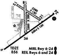
Runways
Runway Summary
| Runways: | 06/24 13/31 18/36 |
| Longest Runway: | 06/24 is 5504 ft (1678 m) long |
| Runways with an Instrument Approach: | 24 |
FEP Airport Runway Details
| Runway 06/24 | 5504 ft x 100 ft (1678 m x 30 m) | |
| Surface: | Asphalt - Good condition - Saw-cut or plastic grooved | |
| Runway Edge Lights: | Medium Intensity | |
Runway Weight Bearing Capacity (in thousands of pounds) |
||
| Single Wheel Landing Gear: | 20.0 | |
| Dual Wheel Landing Gear: | 60.0 | |
Runway 06 |
Runway 24 |
|
Elevation: |
859.0 | 840.6 |
Latitude: |
42-14-23.7959N | 42-14-55.5871N |
Longitude: |
089-35-24.3809W | 089-34-25.0269W |
|
Runway True Alignment: |
054 | 234 |
ILS Type: |
ILS/DME | |
Glide Path Angle: |
3.0 degrees | 3.0 degrees |
Traffic Pattern: |
Left | Left |
Runway Markings Type: |
Nonprecision Instrument | Precision Instrument |
Runway Markings Condition: |
Good | Good |
Object at End: |
TREE | |
Object Height: |
52 | |
Distance from End: |
2118 | |
Object Centerline Offset: |
243 ft. right of centerline | |
Visual Glide Slope Indicators: |
4-Light PAPI On Left Side Of Runway | 4-Light PAPI On Left Side Of Runway |
Approach Light System: |
1,400 Foot Medium Intensity Approach Lighting System With Runway Alignment Indicator Lights | |
REIL: |
No | No |
Touchdown Lights: |
No | No |
Centerline Lights: |
No | No |
Threshold Crossing Height: |
50 | 46 |
| Runway 13/31 | 2285 ft x 150 ft (696 m x 46 m) | |
| Runway Length Source: | NGS as of 10/12/2001 | |
| Surface: | Asphalt - Good condition - No special surface treatment | |
Runway 13 |
Runway 31 |
|
Elevation: |
834.7 | 841.1 |
Latitude: |
42-15-02.7778N | 42-14-49.5069N |
Longitude: |
089-35-04.4789W | 089-34-39.9126W |
|
Runway True Alignment: |
126 | 306 |
Glide Path Angle: |
0.0 degrees | 0.0 degrees |
Traffic Pattern: |
Left | Left |
Runway Markings Type: |
None | None |
Object Centerline Offset: |
243 ft. right of centerline | |
REIL: |
No | No |
Touchdown Lights: |
No | No |
Centerline Lights: |
No | No |
| Runway 18/36 | 2404 ft x 150 ft (733 m x 46 m) | |
| Runway Length Source: | STATE as of 11/30/2016 | |
| Surface: | Asphalt - Good condition - No special surface treatment | |
Runway 18 |
Runway 36 |
|
Elevation: |
835.0 | 844.9 |
Latitude: |
42-15-02.7200N | 42-14-39.0006N |
Longitude: |
089-34-59.0600W | 089-34-58.6085W |
|
Runway True Alignment: |
179 | 359 |
Glide Path Angle: |
0.0 degrees | 0.0 degrees |
Traffic Pattern: |
Left | Left |
Runway Markings Type: |
None | None |
Object Centerline Offset: |
243 ft. right of centerline | |
REIL: |
No | No |
Touchdown Lights: |
No | No |
Centerline Lights: |
No | No |
Services
Airframe Repair: |
None |
Powerplant Repair: |
None |
Bottled Oxygen: |
None |
Bulk Oxygen: |
None |
Fuel Available: |
100LL |
Landing Fees: |
No |
Parking: |
Hangars and tiedowns available |
Maps & Diagrams
FEP Sectional
Flight Planning
at skyvector.com
at skyvector.com