Location
Latitude: |
38-03-25.5650N (38.057101) |
Longitude: |
097-16-30.8220W (-97.275228) |
Elevation: |
1533.5 feet MSL (467 m MSL) |
Magnetic Variation: |
3 E (as of April 2024 from WMM2020 model) |
Time Zone: |
UTC -6.0 (Standard Time) UTC -5.0 (Daylight Savings Time) |
From City: |
03 N.M. E of Newton, Kansas |
Found On: |
Wichita Chart |
FAA Region: |
ACE |
Contacts
Manager: |
Publicly owned: |
| BRIAN PALMER P.O. BOX 426 NEWTON, KS 67114 316-284-6084 |
CITY OF NEWTON HARVEY CO 810 N. OLIVER ROAD - BOX 426 NEWTON, KS 67114 316-284-6089 |
Operations
Airport Status: |
Operational |
Facility Use: |
Public |
Type: |
Airport |
Activation Date: |
02/1944 |
Control tower: |
No |
Attendance (Months/Days/Hours): |
Months/Days/Hours ALL/ALL/0700-2300 |
Boundary ARTCC: |
ZKC (Kansas City) |
Responsible ARTCC: |
ZKC (Kansas City) |
Lighting Schedule: |
SEE RMK |
Segmented Circle Indicator: |
No |
Traffic Pattern Altitude (MSL): |
2534 feet (772 m) |
NOTAMs Facility: |
EWK |
NOTAM-D Service: |
Yes |
International Airport of Entry: |
No |
Customs Landing Rights: |
No |
Military Landing Rights: |
Yes |
Civil/Military Joint Use: |
No |
Based Aircraft
| Single Engine: | 75 |
| Multi Engine: | 4 |
| Jet Engine: | 1 |
| GA Helicopters: | 1 |
Annual Operations (as of 08/21/2019)
| Total Operations: | 65044 | |
| Air Taxi: | 700 | 1.1% |
| GA Local: | 38519 | 59.2% |
| GA Itinerant: | 25675 | 39.5% |
| Military Aircraft: | 150 | 0.2% |
Communications
| CTAF: | 123.000 |
| Unicom: | 123.000 |
| Approach: | WICHITA 125.5 125.5 125.5 |
| Departure: | WICHITA 125.5 125.5 125.5 |
| AWOS-3PT: | 123.875 (316-283-8789) |
Fixed Based Operators (FBOs) & Fuel
(Click on a business for detail)
Please help us keep this information up to date. This is a FREE SERVICE just like everything else on Airport Guide! If you see that a business needs to be added, modified, or deleted please fill out our Update Form.
To add, modify, or delete a business click here.
Please help us keep this information up to date. This is a FREE SERVICE just like everything else on Airport Guide! If you see that a business needs to be added, modified, or deleted please fill out our Update Form.
Area Code: 316 |
| Business Name | Frequency | Phone | Fuel Grade |
|---|---|---|---|
| Blue Jay Aviation
Update FBO info |
654-3847 | ||
| City of Newton and Harvey County
Update FBO info |
Unicom 123.0 | 284-6084, 800-899-2485 | 100LL, Jet A |
| Hesston College Aviation, Inc.
Website Update FBO info |
Unicom 123.3 | 316-283-6161 | |
| Horst Aviation, Inc.
Update FBO info |
Unicom 123.0 | 283-7886 | 100LL, Jet A, MOGAS |
| Midwest Aircraft Services, Inc.
Update FBO info |
283-5915 | ||
| RTR Corp.
Update FBO info |
282-6555, 636-4144 |
Flight Service Stations
| Primary | Alternate | |
| FSS on Field: | N | |
| FSS Name (ID): | Wichita(ICT) | |
| Frequency: | ||
| Toll Free Phone: | 1-800-WX-BRIEF |
Instrument Procedures / Charts
FAA Terminal Procedures valid from 0901Z 03/21/24 to 0901Z 04/18/24.
There are various types of charts available for an airport. They are listed in the Page Type column. Here is a legend for those types:
APD - Airport Diagram
DP - Departure Procedure Charts
HOT - Hot Spots
IAP - Instrument Approach Procedure Charts
MIN - Minimums
STAR - Standard Terminal Arrival Charts
| Page Type | Page Name | Volume | Action Since Last Cycle |
|---|---|---|---|
| IAP | ILS OR LOC RWY 17 | NC-2 | |
| IAP | RNAV (GPS) RWY 17 | NC-2 | |
| IAP | RNAV (GPS) RWY 35 | NC-2 | |
| MIN | ALTERNATE MINIMUMS | NC-2 | |
| MIN | TAKEOFF MINIMUMS | NC-2 |
Terminal Procedures are only available for airports in several countries with more being added all the time. If you are looking for a specific country's charts, please send an email to support(at)airportguide.com stating the country name. This will be used to prioritize the implementation.
Navigation Aids (Navaids) near EWK
| Dist (NM) | ID | Morse Code | Name | Type | Freq | True Hdg | Mag Hdg |
|---|---|---|---|---|---|---|---|
| 0.4 | EWK | . . _ _ _ . _ | Newton | NDB | 281 | 11 | 8 |
| 5.3 | CA | _ . _ . . _ | Harvs | NDB | 395 | 359 | 356 |
| 23.7 | ICT | . . _ . _ . _ | Wichita | VORTAC | 113.80 | 218 | 215 |
| 26.1 | IAB | . . . _ _ . . . | Mc Connell | TACAN | 116.50 | 179 | 176 |
| 26.1 | MPR | _ _ . _ _ . . _ . | Mc Pherson | NDB | 227 | 312 | 309 |
| 26.3 | ICT | . . _ . _ . _ | Wichita | VOT | 114.00 | 196 | 193 |
| 30.0 | IC | . . _ . _ . | Piche | NDB | 332 | 196 | 193 |
| 31.0 | HU | . . . . . . _ | Saltt | NDB | 404 | 277 | 274 |
| 31.4 | HUT | . . . . . . _ _ | Hutchinson | VOR-DME | 116.80 | 263 | 260 |
| 41.3 | SL | . . . . _ . . | Flory | NDB | 344 | 335 | 332 |
| 43.9 | HRU | . . . . . _ . . . _ | Herington | NDB | 407 | 29 | 26 |
| 44.3 | EGT | . _ _ . _ | Wellington | NDB | 414 | 187 | 184 |
| 48.1 | LYO | . _ . . _ . _ _ _ _ _ | Lyons | NDB | 386 | 291 | 288 |
| 54.6 | SLN | . . . . _ . . _ . | Salina | VORTAC | 117.10 | 342 | 339 |
| 55.4 | EMP | . _ _ . _ _ . | Emporia | VORTAC | 112.80 | 74 | 71 |
| 58.1 | FRI | . . _ . . _ . . . | Fort Riley | VOR | 109.40 | 19 | 16 |
| 59.1 | SO | . . . _ _ _ | Sawcy | NDB | 353 | 168 | 165 |
| 62.4 | CVY | _ . _ . . . . _ _ . _ _ | Cavalry | NDB | 314 | 21 | 18 |
| 68.7 | ANY | . _ _ . _ . _ _ | Anthony | TACAN | 112.90 | 218 | 215 |
| 71.2 | MHK | _ _ . . . . _ . _ | Manhattan | VOR-DME | 110.20 | 23 | 20 |
Nearby Airports with Fuel
Notices to Airmen (NOTAMS)
Remarks
| A110-1 | TOUCHDOWN AREA OF RY 26 IS NOT VISIBLE FRM TOUCHDOWN AREA OF EITHER RY 17 OR RY 35. |
| A110-2 | SELF-SERVE AIRCRAFT WASH BAY. |
| A110-3 | COMPASS ROSE RIGHT OF APCH END RY 35 |
| A110-5 | FOR CD CTC WICHITA APCH AT 316-350-1520. |
| A17 | PHONE NUMBER FOR FUEL AFT HRS 316-284-6084 AND IS POSTED AT ARPT. |
| A32-08/26 | RWY 08/26 60 FT WIDE ASPHALT. |
| A43-08 | RWY 08 PAPI OTS. |
| A81-APT | ACTVT MALSR RWY 17; REIL RWYS 08 & 26 &35; VASI RWY 35; PAPI RWYS 08 & 26 & 17; HIRL RWY 17/35 - CTAF. |
| E111 | PROVIDED A CLEAR APPROACH TO EACH RWY IS MAINTAINED FOR A MINIMUM 20:1 GLIDE SLOPE AND THE TRANSITIONAL SURFACE IS MAINTAINED FOR A 7:1 SLOPE. |
Runways
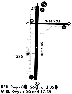
Runway Summary
| Runways: | 08/26 17/35 |
| Longest Runway: | 17/35 is 7003 ft (2135 m) long |
| Runways with an Instrument Approach: | 17 |
EWK Airport Runway Details
| Runway 08/26 | 3501 ft x 60 ft (1067 m x 18 m) | |
| Runway Length Source: | 3RD PARTY SURVEY as of 02/22/2005 | |
| Surface: | Asphalt - Good condition - No special surface treatment | |
| Runway Pavement Class: | 6 /F/D/Y/U | |
| Runway Edge Lights: | Medium Intensity | |
Runway Weight Bearing Capacity (in thousands of pounds) |
||
| Single Wheel Landing Gear: | 13.0 | |
Runway 08 |
Runway 26 |
|
Elevation: |
1533.5 | 1533.3 |
Latitude: |
38-03-38.7500N | 38-03-38.7500N |
Longitude: |
097-16-44.3600W | 097-16-00.6000W |
|
Runway True Alignment: |
090 | 270 |
Glide Path Angle: |
3.0 degrees | 3.0 degrees |
Runway Markings Type: |
Basic | Basic |
Runway Markings Condition: |
Good | Good |
Visual Glide Slope Indicators: |
4-Light PAPI On Left Side Of Runway | 4-Light PAPI On Left Side Of Runway |
REIL: |
Yes | Yes |
Threshold Crossing Height: |
29 | 29 |
Declared Distances |
||
Take Off Run Avbl. (TORA): |
3501 | 3501 |
Take Off Distance Avbl. (TODA): |
3501 | 3501 |
Actual Stop Dist. Avbl. (ASDA): |
3501 | 3501 |
Landing Dist. Avbl. (LDA): |
3501 | 3501 |
| Runway 17/35 | 7003 ft x 100 ft (2135 m x 30 m) | |
| Runway Length Source: | 3RD PARTY SURVEY as of 02/22/2005 | |
| Surface: | Asphalt - Good condition - No special surface treatment | |
| Runway Pavement Class: | 21 /R/C/X/U | |
| Runway Edge Lights: | High Intensity | |
Runway Weight Bearing Capacity (in thousands of pounds) |
||
| Single Wheel Landing Gear: | 50.0 | |
| Dual Wheel Landing Gear: | 75.0 | |
| Dual Tandem Wheel Landing Gear: | 135.0 | |
Runway 17 |
Runway 35 |
|
Elevation: |
1528.8 | 1524.5 |
Latitude: |
38-03-53.5900N | 38-02-44.3600N |
Longitude: |
097-16-34.9900W | 097-16-34.9900W |
|
Runway True Alignment: |
180 | 000 |
ILS Type: |
ILS | |
Glide Path Angle: |
3.0 degrees | 3.0 degrees |
Traffic Pattern: |
Left | Left |
Runway Markings Type: |
Precision Instrument | Nonprecision Instrument |
Runway Markings Condition: |
Good | Good |
Visual Glide Slope Indicators: |
2-Light PAPI On Left Side Of Runway | 4-Box VASI On Left Side Of Runway |
Approach Light System: |
1,400 Foot Medium Intensity Approach Lighting System With Runway Alignment Indicator Lights | |
REIL: |
Yes | |
Threshold Crossing Height: |
53 | 50 |
Declared Distances |
||
Take Off Run Avbl. (TORA): |
7003 | 7003 |
Take Off Distance Avbl. (TODA): |
7003 | 7003 |
Actual Stop Dist. Avbl. (ASDA): |
6705 | 7003 |
Landing Dist. Avbl. (LDA): |
6705 | 7003 |
Services
Bottled Oxygen: |
None |
Fuel Available: |
100LL, Jet A |
Landing Fees: |
No |
Parking: |
Hangars and tiedowns available |
Maps & Diagrams
EWK Sectional
Flight Planning
at skyvector.com
at skyvector.com