Location
Latitude: |
36-13-15.6000N (36.221) |
Longitude: |
101-11-40.2000W (-101.1945) |
Elevation: |
3090.0 feet MSL (942 m MSL) |
Magnetic Variation: |
5.3 E (as of April 2024 from WMM2020 model) |
Time Zone: |
UTC -6.0 (Standard Time) UTC -5.0 (Daylight Savings Time) |
From City: |
01 N.M. N of Spearman, Texas |
Found On: |
Wichita Chart |
FAA Region: |
ASW |
Contacts
Manager: |
Publicly owned: |
| JUSTIN PARKER PO BOX 37 SPEARMAN, TX 79081 806-659-2524 |
CITY OF SPEARMAN PO BOX 37 SPEARMAN, TX 79081 806-659-2524 |
Operations
Airport Status: |
Operational |
Facility Use: |
Public |
Type: |
Airport |
Activation Date: |
06/1982 |
Control tower: |
No |
Attendance (Months/Days/Hours): |
Months/Days/Hours Unattended |
Boundary ARTCC: |
ZAB (Albuquerque) |
Responsible ARTCC: |
ZAB (Albuquerque) |
Lighting Schedule: |
SEE RMK |
Segmented Circle Indicator: |
Yes |
Traffic Pattern Altitude (MSL): |
4090 feet (1247 m) |
NOTAMs Facility: |
FTW |
NOTAM-D Service: |
Yes |
Based Aircraft
| Single Engine: | 13 |
| GA Helicopters: | 1 |
Annual Operations (as of 09/16/2021)
| Total Operations: | 3300 | |
| GA Local: | 2200 | 66.7% |
| GA Itinerant: | 1100 | 33.3% |
Communications
| CTAF: | 122.900 |
| AWOS-3P: | 118.925 (806-644-6824) |
- APCH/DEP SVC PRVDD BY ALBUQUERQUE ARTCC (ZAB) ON FREQS 127.85/285.475 (AMARILLO RCAG).
Fixed Based Operators (FBOs) & Fuel
(Click on a business for detail)
Please help us keep this information up to date. This is a FREE SERVICE just like everything else on Airport Guide! If you see that a business needs to be added, modified, or deleted please fill out our Update Form.
To add, modify, or delete a business click here.
Please help us keep this information up to date. This is a FREE SERVICE just like everything else on Airport Guide! If you see that a business needs to be added, modified, or deleted please fill out our Update Form.
Area Code: 806 |
| Business Name | Frequency | Phone | Fuel Grade |
|---|
Flight Service Stations
| Primary | Alternate | |
| FSS on Field: | N | |
| FSS Name (ID): | Fort Worth(FTW) | |
| Frequency: | ||
| Toll Free Phone: | 1-800-WX-BRIEF |
Instrument Procedures / Charts
FAA Terminal Procedures valid from 0901Z 03/21/24 to 0901Z 04/18/24.
There are various types of charts available for an airport. They are listed in the Page Type column. Here is a legend for those types:
APD - Airport Diagram
DP - Departure Procedure Charts
HOT - Hot Spots
IAP - Instrument Approach Procedure Charts
MIN - Minimums
STAR - Standard Terminal Arrival Charts
| Page Type | Page Name | Volume | Action Since Last Cycle |
|---|---|---|---|
| IAP | RNAV (GPS) RWY 02 | SC-2 | |
| IAP | RNAV (GPS) RWY 20 | SC-2 | |
| MIN | TAKEOFF MINIMUMS | SC-2 |
Terminal Procedures are only available for airports in several countries with more being added all the time. If you are looking for a specific country's charts, please send an email to support(at)airportguide.com stating the country name. This will be used to prioritize the implementation.
Navigation Aids (Navaids) near E42
| Dist (NM) | ID | Morse Code | Name | Type | Freq | True Hdg | Mag Hdg |
|---|---|---|---|---|---|---|---|
| 24.5 | PYX | . _ _ . _ . _ _ _ . . _ | Perryton | NDB | 266 | 61 | 56 |
| 26.5 | BGD | _ . . . _ _ . _ . . | Borger | TACAN | 108.60 | 200 | 195 |
| 32.7 | GUY | _ _ . . . _ _ . _ _ | Guymon | NDB | 275 | 332 | 327 |
| 37.8 | PPA | . _ _ . . _ _ . . _ | Pampa | NDB | 368 | 164 | 159 |
| 46.1 | LB | . _ . . _ . . . | Panck | NDB | 383 | 14 | 9 |
| 50.6 | LBL | . _ . . _ . . . . _ . . | Liberal | TACAN | 112.30 | 12 | 7 |
| 57.2 | HQG | . . . . _ _ . _ _ _ . | Hugoton | NDB | 365 | 351 | 346 |
| 57.4 | EHA | . . . . . . _ | Elkhart | NDB | 377 | 324 | 318 |
| 64.0 | MMB | _ _ _ _ _ . . . | Mitbee | VORTAC | 115.60 | 83 | 78 |
| 64.1 | PNH | . _ _ . _ . . . . . | Panhandle | VORTAC | 116.60 | 202 | 197 |
| 65.9 | DHT | _ . . . . . . _ | Dalhart | VORTAC | 112.00 | 263 | 257 |
| 71.0 | AM | . _ _ _ | Pande | NDB | 251 | 204 | 199 |
| 83.0 | ULS | . . _ . _ . . . . . | Ulysses | NDB | 395 | 354 | 349 |
| 85.1 | BFK | _ . . . . . _ . _ . _ | Buffalo | NDB | 215 | 62 | 57 |
| 88.7 | JHN | . _ _ _ . . . . _ . | Bear Creek | NDB | 341 | 343 | 338 |
| 92.3 | SYO | . . . _ . _ _ _ _ _ | Sayre | VORTAC | 115.20 | 124 | 119 |
| 95.4 | CAO | _ . _ . . _ _ _ _ | Clayton | NDB | 332 | 278 | 272 |
| 98.0 | MDF | _ _ _ . . . . _ . | Mooreland | NDB | 284 | 80 | 75 |
| 98.7 | HRX | . . . . . _ . _ . . _ | Hereford | NDB | 341 | 214 | 208 |
| 99.1 | GC | _ _ . _ . _ . | Pieve | NDB | 347 | 13 | 8 |
Nearby Airports with Fuel
Notices to Airmen (NOTAMS)
Remarks
| A110*G | THIS AIRPORT HAS BEEN SURVEYED BY THE NATIONAL GEODETIC SURVEY. |
| A110-1 | NO LINE OF SIGHT BTN RY ENDS. |
| A110-2 | FOR CD CTC ALBUQUERQUE ARTCC AT 505-856-4861. |
| A14 | PUBLIC WORKS DIR. ADD'L CTC, CITY SECRETARY CHERYL GIBSON-SALGADO. |
| A43-02 | PAPI OTS |
| A70-FUEL-10 | 0LL FOR FUEL CALL 806-659-2422 & HGR SPACE 806-659-2524 MON-SAT 0730-1900. |
| A81-APT | MIRL RWY 02/20 PRESET LOW INTST; TO INCR INTST & ACTVT PAPI RWYS 02 & 20 - CTAF. |
Runways
Runway Summary
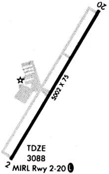
| Runways: | 02/20 |
| Longest Runway: | 02/20 is 5022 ft (1531 m) long |
| Runways with an Instrument Approach: |
E42 Airport Runway Details
| Runway 02/20 | 5022 ft x 75 ft (1531 m x 23 m) | |
| Runway Length Source: | NGS as of 10/18/2008 | |
| Surface: | Asphalt - Fair condition - No special surface treatment | |
| Runway Edge Lights: | Medium Intensity | |
Runway Weight Bearing Capacity (in thousands of pounds) |
||
| Single Wheel Landing Gear: | 12.5 | |
Runway 02 |
Runway 20 |
|
Elevation: |
3086.2 | 3090.0 |
Latitude: |
36-12-54.0048N | 36-13-37.2635N |
Longitude: |
101-11-55.2343W | 101-11-25.1518W |
|
Runway True Alignment: |
029 | 209 |
Glide Path Angle: |
3.0 degrees | 3.0 degrees |
Runway Markings Type: |
Nonprecision Instrument | Nonprecision Instrument |
Runway Markings Condition: |
Good | Good |
Object at End: |
ROAD | |
Object Height: |
10 | |
Distance from End: |
530 | |
Object Centerline Offset: |
300 ft. left of centerline | |
Visual Glide Slope Indicators: |
2-Light PAPI On Left Side Of Runway | 2-Light PAPI On Left Side Of Runway |
Threshold Crossing Height: |
39 | 40 |
Services
Airframe Repair: |
Major |
Powerplant Repair: |
Major |
Bottled Oxygen: |
None |
Bulk Oxygen: |
None |
Fuel Available: |
100LL, Jet A |
Landing Fees: |
No |
Parking: |
Hangars and tiedowns available |
Maps & Diagrams
E42 Sectional
Flight Planning
at skyvector.com
at skyvector.com