Location
Latitude: |
41-49-50.7000N (41.83075) |
Longitude: |
090-19-44.3000W (-90.328972) |
Elevation: |
707.7 feet MSL (216 m MSL) |
Magnetic Variation: |
2.1 W (as of April 2024 from WMM2020 model) |
Time Zone: |
UTC -6.0 (Standard Time) UTC -5.0 (Daylight Savings Time) |
From City: |
06 N.M. SW of Clinton, Iowa |
Found On: |
Chicago Chart |
FAA Region: |
ACE |
Contacts
Manager: |
Publicly owned: |
| MARLANA NASS 2000 S 60TH ST. CLINTON, IA 52732 563-242-3292 |
CITY OF CLINTON CITY HALL CLINTON, IA 52732 563-242-2144 |
Operations
Airport Status: |
Operational |
Facility Use: |
Public |
Type: |
Airport |
Activation Date: |
10/1945 |
Control tower: |
No |
Attendance (Months/Days/Hours): |
Months/Days/Hours ALL/MON-FRI/0800-1700 |
Boundary ARTCC: |
ZAU (Chicago) |
Responsible ARTCC: |
ZAU (Chicago) |
Lighting Schedule: |
SEE RMK |
Segmented Circle Indicator: |
No |
Traffic Pattern Altitude (MSL): |
1708 feet (521 m) |
NOTAMs Facility: |
CWI |
NOTAM-D Service: |
Yes |
International Airport of Entry: |
No |
Customs Landing Rights: |
No |
Military Landing Rights: |
Yes |
Civil/Military Joint Use: |
No |
Based Aircraft
| Single Engine: | 29 |
| Multi Engine: | 1 |
| Jet Engine: | 1 |
Annual Operations (as of 06/22/2022)
| Total Operations: | 11900 | |
| Air Taxi: | 262 | 2.2% |
| GA Local: | 4524 | 38.0% |
| GA Itinerant: | 6786 | 57.0% |
| Military Aircraft: | 328 | 2.8% |
Communications
| CTAF: | 122.800 |
| Unicom: | 122.800 |
| Clearance Del.: | 118.5 118.5 118.5 |
| Approach: | QUAD CITY CHICAGO ARTCC |
| Departure: | QUAD CITY CHICAGO ARTCC |
| AWOS-3PT: | 125.525 (563-243-8934) |
- APCH/DEP SVC PRVDD BY CHICAGO ARTCC ON FREQS 118.75/377.05 (MOLINE RCAG) WHEN QUAD CITY APCH CLSD.
Fixed Based Operators (FBOs) & Fuel
(Click on a business for detail)
Please help us keep this information up to date. This is a FREE SERVICE just like everything else on Airport Guide! If you see that a business needs to be added, modified, or deleted please fill out our Update Form.
To add, modify, or delete a business click here.
Please help us keep this information up to date. This is a FREE SERVICE just like everything else on Airport Guide! If you see that a business needs to be added, modified, or deleted please fill out our Update Form.
Area Code: 319 |
| Business Name | Frequency | Phone | Fuel Grade |
|---|
Flight Service Stations
| Primary | Alternate | |
| FSS on Field: | N | |
| FSS Name (ID): | Fort Dodge(FOD) | |
| Frequency: | ||
| Toll Free Phone: | 1-800-WX-BRIEF |
Instrument Procedures / Charts
FAA Terminal Procedures valid from 0901Z 03/21/24 to 0901Z 04/18/24.
There are various types of charts available for an airport. They are listed in the Page Type column. Here is a legend for those types:
APD - Airport Diagram
DP - Departure Procedure Charts
HOT - Hot Spots
IAP - Instrument Approach Procedure Charts
MIN - Minimums
STAR - Standard Terminal Arrival Charts
| Page Type | Page Name | Volume | Action Since Last Cycle |
|---|---|---|---|
| APD | AIRPORT DIAGRAM | NC-3 | |
| IAP | ILS OR LOC RWY 03 | NC-3 | |
| IAP | RNAV (GPS) RWY 03 | NC-3 | |
| IAP | RNAV (GPS) RWY 14 | NC-3 | |
| IAP | RNAV (GPS) RWY 21 | NC-3 | |
| IAP | RNAV (GPS) RWY 32 | NC-3 | |
| IAP | VOR/DME RWY 21 | NC-3 | |
| MIN | ALTERNATE MINIMUMS | NC-3 | |
| MIN | TAKEOFF MINIMUMS | NC-3 |
Terminal Procedures are only available for airports in several countries with more being added all the time. If you are looking for a specific country's charts, please send an email to support(at)airportguide.com stating the country name. This will be used to prioritize the implementation.
Navigation Aids (Navaids) near CWI
| Dist (NM) | ID | Morse Code | Name | Type | Freq | True Hdg | Mag Hdg |
|---|---|---|---|---|---|---|---|
| 5.5 | FN | . . _ . _ . | Hillz | NDB | 517 | 210 | 212 |
| 10.1 | CVA | _ . _ . . . . _ . _ | Davenport | VORTAC | 113.80 | 223 | 225 |
| 17.4 | DVN | _ . . . . . _ _ . | Davenport Municipal | VOT | 111.80 | 221 | 223 |
| 25.4 | BOZ | _ . . . _ _ _ _ _ . . | Whiteside | NDB | 254 | 106 | 108 |
| 31.9 | DB | _ . . _ . . . | Zilom | NDB | 341 | 337 | 339 |
| 33.6 | MZV | _ _ _ _ . . . . . _ | Moline | VOR-DME | 114.40 | 204 | 206 |
| 36.8 | PLL | . _ _ . . _ . . . _ . . | Polo | VOR-DME | 111.20 | 77 | 79 |
| 38.2 | DBQ | _ . . _ . . . _ _ . _ | Dubuque | VORTAC | 115.80 | 333 | 335 |
| 46.2 | DDD | _ . . _ . . _ . . | Port City | DME | 116.5 | 233 | 235 |
| 52.3 | BDF | _ . . . _ . . . . _ . | Bradford | VORTAC | 114.70 | 140 | 142 |
| 53.8 | GBG | _ _ . _ . . . _ _ . | Galesburg | DME | 109.8 | 185 | 187 |
| 55.6 | RFD | . _ . . . _ . _ . . | Rockford | DME | 110.8 | 64 | 67 |
| 57.5 | RF | . _ . . . _ . | Gilmy | NDB | 275 | 72 | 75 |
| 60.5 | IOW | . . _ _ _ . _ _ | Iowa City | VOR-DME | 116.20 | 252 | 254 |
| 63.6 | MRJ | _ _ . _ . . _ _ _ | Mineral Point | NDB | 365 | 4 | 6 |
| 65.2 | CID | _ . _ . . . _ . . | Cedar Rapids | VOR-DME | 114.10 | 273 | 275 |
| 68.8 | AWG | . _ . _ _ _ _ . | Washington | NDB | 219 | 241 | 243 |
| 69.7 | JVL | . _ _ _ . . . _ . _ . . | Janesville | VOR-DME | 114.30 | 50 | 53 |
| 71.7 | BRL | _ . . . . _ . . _ . . | Burlington | VOR-DME | 111.40 | 202 | 204 |
| 71.9 | OIX | _ _ _ . . _ . . _ | Ottawa | NDB | 266 | 112 | 115 |
Nearby Airports with Fuel
Notices to Airmen (NOTAMS)
Remarks
| A11 | CHMN ARPT CMSN: 563-242-3292 |
| A110-4 | RY 03 IS CALM WIND RY. |
| A110-7 | FOR CD CTC CHICAGO ARTCC AT 630-906-8921. |
| A81-APT | ACTVT HIRL RY 03/21 & MIRL RY 14/32; MALSR RY 03; VASI RY 21; PAPI RYS 14 & 32; REIL RYS 14 & 21 - 118.5. |
| E111 | PRVDD APCH TO EACH RWY IS MAINTD FOR A MIN 34:1 OR 20:1 GS; WHICHEVER IS APPLICABLE; AND THE TRANSITIONAL SURFACE BE MAINTAINED FOR A 7:1 SLOPE. |
Runways
Runway Summary
| Runways: | 03/21 14/32 |
| Longest Runway: | 03/21 is 5204 ft (1586 m) long |
| Runways with an Instrument Approach: | 03 |
CWI Airport Runway Details
| Runway 03/21 | 5204 ft x 100 ft (1586 m x 30 m) | |
| Runway Length Source: | 3RD PARTY SURVEY as of 09/16/2010 | |
| Surface: | Concrete - Good condition - No special surface treatment | |
| Runway Pavement Class: | 22 /R/B/W/T | |
| Runway Edge Lights: | High Intensity | |
Runway Weight Bearing Capacity (in thousands of pounds) |
||
| Single Wheel Landing Gear: | 68.0 | |
| Dual Wheel Landing Gear: | 85.0 | |
Runway 03 |
Runway 21 |
|
Elevation: |
690.9 | 707.5 |
Latitude: |
41-49-34.8112N | 41-50-19.4858N |
Longitude: |
090-19-58.9120W | 090-19-24.8958W |
|
Runway True Alignment: |
030 | 210 |
ILS Type: |
ILS/DME | |
Glide Path Angle: |
0.0 degrees | 3.0 degrees |
Traffic Pattern: |
Left | Left |
Runway Markings Type: |
Precision Instrument | Precision Instrument |
Runway Markings Condition: |
Good | Good |
Visual Glide Slope Indicators: |
4-Box VASI On Left Side Of Runway | |
Approach Light System: |
1,400 Foot Medium Intensity Approach Lighting System With Runway Alignment Indicator Lights | |
REIL: |
Yes | |
Threshold Crossing Height: |
34 | |
Declared Distances |
||
Take Off Run Avbl. (TORA): |
5204 | 5204 |
Take Off Distance Avbl. (TODA): |
5204 | 5204 |
Actual Stop Dist. Avbl. (ASDA): |
5204 | 5204 |
Landing Dist. Avbl. (LDA): |
5204 | 5204 |
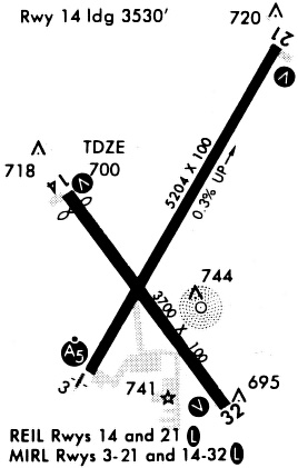
| Runway 14/32 | 4201 ft x 75 ft (1280 m x 23 m) | |
| Runway Length Source: | 3RD PARTY SURVEY as of 09/16/2010 | |
| Surface: | Concrete - Good condition - No special surface treatment | |
| Runway Pavement Class: | 16 /R/D/W/T | |
| Runway Edge Lights: | Medium Intensity | |
Runway Weight Bearing Capacity (in thousands of pounds) |
||
| Single Wheel Landing Gear: | 41.0 | |
| Dual Wheel Landing Gear: | 55.0 | |
Runway 14 |
Runway 32 |
|
Elevation: |
701.4 | 689.9 |
Latitude: |
41-49-59.5242N | 41-49-25.7361N |
Longitude: |
090-20-03.2687W | 090-19-31.0425W |
|
Runway True Alignment: |
144 | 325 |
Glide Path Angle: |
3.0 degrees | 3.0 degrees |
Traffic Pattern: |
Left | Left |
Runway Markings Type: |
Nonprecision Instrument | Nonprecision Instrument |
Runway Markings Condition: |
Good | Good |
Visual Glide Slope Indicators: |
4-Light PAPI On Left Side Of Runway | 4-Light PAPI On Left Side Of Runway |
REIL: |
Yes | |
Threshold Crossing Height: |
40 | 40 |
Declared Distances |
||
Take Off Run Avbl. (TORA): |
4200 | 4200 |
Take Off Distance Avbl. (TODA): |
4200 | 4200 |
Actual Stop Dist. Avbl. (ASDA): |
4200 | 4200 |
Landing Dist. Avbl. (LDA): |
4200 | 4200 |
Services
Airframe Repair: |
Major |
Powerplant Repair: |
Major |
Bottled Oxygen: |
None |
Bulk Oxygen: |
None |
Fuel Available: |
100LL, Jet A |
Landing Fees: |
No |
Parking: |
Hangars and tiedowns available |
Maps & Diagrams
CWI Sectional
Flight Planning
at skyvector.com
at skyvector.com