
Location
Latitude: |
42-46-30.7196N (42.7752) |
Longitude: |
141-41-31.2048E (141.692001) |
Elevation: |
82 feet MSL (25 m MSL) |
Magnetic Variation: |
9.8 W (as of April 2024 from WMM2020 model) |
Time Zone: |
UTC +9.0 (Standard Time) UTC +9.0 (Daylight Savings Time) |
Contacts
Manager: |
: |
Operations
Airport Status: |
Operational |
Facility Use: |
Public |
Type: |
Airport |
Traffic Pattern Altitude (MSL): |
1082 feet (330 m) |
Based Aircraft
Annual Operations (as of )
Communications
| CHITOSE TWR: | 118.8 |
| CHITOSE CLNC DEL: | 121.9 |
| CHITOSE GND: | 121.6 |
| CHITOSE APP: | 120.1 |
| CHITOSE DEP: | 124.7 |
| ATIS: | 128.6 |
| 01L: | 110.9 |
| 01R: | 110.75 |
| TCA: | 127.7 |
Fixed Based Operators (FBOs) & Fuel
(Click on a business for detail)
Please help us keep this information up to date. This is a FREE SERVICE just like everything else on Airport Guide! If you see that a business needs to be added, modified, or deleted please fill out our Update Form.
To add, modify, or delete a business click here.
Please help us keep this information up to date. This is a FREE SERVICE just like everything else on Airport Guide! If you see that a business needs to be added, modified, or deleted please fill out our Update Form.
| Business Name | Frequency | Phone | Fuel Grade |
|---|
Flight Service Stations
| Primary | Alternate | |
| FSS on Field: | ||
| FSS Name (ID): | ||
| Frequency: | ||
| Toll Free Phone: |
Instrument Procedures / Charts
Terminal Procedures are only available for airports in several countries with more being added all the time. If you are looking for a specific country's charts, please send an email to support(at)airportguide.com stating the country name. This will be used to prioritize the implementation.
Navigation Aids (Navaids) near CTS
| Dist (NM) | ID | Morse Code | Name | Type | Freq | True Hdg | Mag Hdg |
|---|---|---|---|---|---|---|---|
| 1.0 | ZYT | Chitose | TACAN | 109.20 | 230 | 240 | |
| 4.5 | CHE | Chitose | VOR-DME | 116.90 | 183 | 193 | |
| 6.4 | CH | Chitose | NDB | 347 | 184 | 194 | |
| 13.6 | NA | Naganuma | NDB | 377 | 352 | 362 | |
| 17.6 | MKE | Mukawa | VOR-DME | 116.40 | 138 | 148 | |
| 28.7 | SP | Sapporo | NDB | 357 | 325 | 335 | |
| 29.5 | SPE | Sapporo | VOR-DME | 113.90 | 324 | 334 | |
| 63.1 | AWE | Asahikawa | VOR-DME | 113.50 | 31 | 41 | |
| 64.9 | OH | Tokachi | NDB | 239 | 82 | 92 | |
| 67.4 | OBE | Obihiro | VOR-DME | 109.65 | 91 | 101 | |
| 69.4 | OB | Obihiro | NDB | 326 | 95 | 105 | |
| 71.2 | HWE | Hakodate | VOR-DME | 112.30 | 212 | 222 | |
| 71.4 | HW | Hakodate | NDB | 388 | 213 | 223 | |
| 95.2 | OM | Ominato | NDB | 353 | 195 | 205 | |
| 95.9 | OMT | Ominato | TACAN | 114.85 | 195 | 205 |
Nearby Airports with Fuel
| Dist (NM) | Name (Airport IDs) | True Hdg | Mag Hdg | Fuel Grade |
|---|
Notices to Airmen (NOTAMS)
Remarks
No remarks for this landing facility
Runways
Runway Summary
| Runways: | 01L/19R 01R/19L |
| Longest Runway: | 01L/19R is 9840 ft (2999 m) long |
| Runways with an Instrument Approach: |
CTS Airport Runway Details
| Runway 01L/19R | 9840 ft x 200 ft (2999 m x 61 m) | |
| Runway Edge Lights: | Yes Intensity | |
Runway 01L |
Runway 19R |
|
Elevation: |
62 | 82 |
Latitude: |
42.76160049438 | 42.78839874267 |
Longitude: |
141.69299316406 | 141.68800354003 |
|
Runway True Alignment: |
353 | 173 |
Glide Path Angle: |
0.0 degrees | 0.0 degrees |
REIL: |
Yes | Yes |
Threshold Elevation: |
62 | 82 |
| Runway 01R/19L | 9840 ft x 200 ft (2999 m x 61 m) | |
| Runway Edge Lights: | Yes Intensity | |
Runway 01R |
Runway 19L |
|
Elevation: |
57 | 77 |
Latitude: |
42.76200103759 | 42.78879928588 |
Longitude: |
141.69599914550 | 141.69200134277 |
|
Runway True Alignment: |
352.6 | 172.6 |
Glide Path Angle: |
0.0 degrees | 0.0 degrees |
REIL: |
Yes | Yes |
Threshold Elevation: |
57 | 77 |
Services
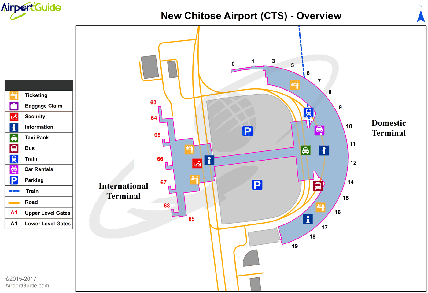
Maps & Diagrams
CTS Sectional
Flight Planning
at skyvector.com
at skyvector.com
