Location
Latitude: |
33-55-27.8412S (-33.9244) |
Longitude: |
150-59-16.8237E (150.988007) |
Elevation: |
29 feet MSL (9 m MSL) |
Magnetic Variation: |
12.8 E (as of April 2024 from WMM2020 model) |
Time Zone: |
UTC +10.0 (Standard Time) UTC +11.0 (Daylight Savings Time) |
Contacts
Manager: |
: |
| Bankstown Airport Limited Airport Avenue, Bankstown Airport Bankstown, NSW, 2200 PH 02 9796 2300, FAX 9791 0230 |
Operations
Airport Status: |
Operational |
Facility Use: |
Public |
Type: |
Airport |
Attendance (Months/Days/Hours): |
Months/Days/Hours 0500-2105 daily local time |
Traffic Pattern Altitude (MSL): |
1029 feet (314 m) |
Based Aircraft
Annual Operations (as of )
Communications
| CTAF: | 132.8 |
| TWR: | 132.8 |
| GND: | 119.9 |
| ATIS: | 120.9 |
| SYDNEY CENTRE: | 124.55 |
Fixed Based Operators (FBOs) & Fuel
(Click on a business for detail)
Please help us keep this information up to date. This is a FREE SERVICE just like everything else on Airport Guide! If you see that a business needs to be added, modified, or deleted please fill out our Update Form.
To add, modify, or delete a business click here.
Please help us keep this information up to date. This is a FREE SERVICE just like everything else on Airport Guide! If you see that a business needs to be added, modified, or deleted please fill out our Update Form.
| Business Name | Frequency | Phone | Fuel Grade |
|---|
Flight Service Stations
| Primary | Alternate | |
| FSS on Field: | ||
| FSS Name (ID): | ||
| Frequency: | ||
| Toll Free Phone: |
Instrument Procedures / Charts
Terminal Procedures are only available for airports in several countries with more being added all the time. If you are looking for a specific country's charts, please send an email to support(at)airportguide.com stating the country name. This will be used to prioritize the implementation.
Navigation Aids (Navaids) near BWU
| Dist (NM) | ID | Morse Code | Name | Type | Freq | True Hdg | Mag Hdg |
|---|---|---|---|---|---|---|---|
| 0.2 | BK | Bankstown | NDB | 416 | 168 | 155 | |
| 3.8 | GLF | Glenfield | NDB | 428 | 189 | 176 | |
| 8.9 | SDM | Sydenham | NDB | 266 | 86 | 73 | |
| 9.7 | SY | Sydney | DME | 112.10 | 96 | 83 | |
| 16.2 | CN | Camden | NDB | 281 | 244 | 231 | |
| 21.2 | RIC | Richmond | TACAN | 110.70 | 333 | 320 | |
| 22.3 | RIC | Richmond | NDB | 347 | 331 | 318 | |
| 33.2 | CAA | Calga (Closed May 2016) | NDB | -1 | 19 | 6 | |
| 36.6 | KAT | Katoomba | NDB | 233 | 290 | 277 | |
| 39.2 | WOL | Wollongong | NDB | 239 | 194 | 181 | |
| 46.2 | BIK | Bindook (Closed May 2016) | NDB | -1 | 250 | 237 | |
| 46.4 | BIK | Bindook | VOR-DME | 116.80 | 250 | 237 | |
| 49.3 | MQD | Mount Mcquoid (Closed May 2016) | NDB | -1 | 8 | 355 | |
| 49.5 | MQD | Mount Mcquoid (Closed Nov 2008) | VOR | -1 | 8 | 355 | |
| 65.5 | NWA | Nowra | TACAN | 116.40 | 199 | 186 | |
| 65.6 | NWA | Nowra | NDB | 359 | 200 | 187 | |
| 67.8 | SLS | Shellys | NDB | 353 | 225 | 212 | |
| 73.2 | BTH | Bathurst | NDB | 383 | 294 | 282 | |
| 75.3 | WMD | West Maitland | VOR | 114.60 | 21 | 8 | |
| 75.3 | WMD | West Maitland | NDB | 224 | 21 | 8 |
Nearby Airports with Fuel
| Dist (NM) | Name (Airport IDs) | True Hdg | Mag Hdg | Fuel Grade |
|---|
Notices to Airmen (NOTAMS)
Remarks
No remarks for this landing facility
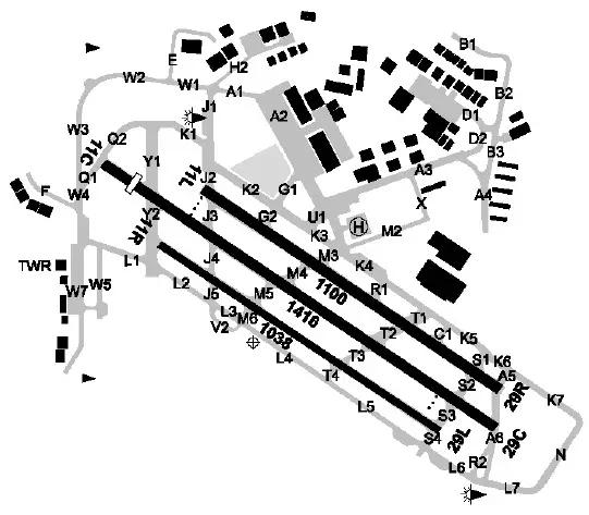
Runways
Runway Summary
| Runways: | 11C/29C 11L/29R 11R/29L |
| Longest Runway: | 11C/29C is 4644 ft (1415 m) long |
| Runways with an Instrument Approach: |
BWU Airport Runway Details
| Runway 11C/29C | 4644 ft x 98 ft (1415 m x 30 m) | |
| Runway Edge Lights: | Yes Intensity | |
Runway 11C |
Runway 29C |
|
Elevation: |
20 | 26 |
Latitude: |
-33.9196014404 | -33.9267997741 |
Longitude: |
150.98399353027 | 150.99600219726 |
|
Runway True Alignment: |
124 | 304 |
Glide Path Angle: |
0.0 degrees | 0.0 degrees |
REIL: |
Yes | Yes |
Threshold Elevation: |
20 | 26 |
Displaced Threshold: |
508 | 196 |
| Runway 11L/29R | 3609 ft x 98 ft (1100 m x 30 m) | |
| Runway Edge Lights: | Yes Intensity | |
Runway 11L |
Runway 29R |
|
Elevation: |
21 | 29 |
Latitude: |
-33.9201011657 | -33.9257011413 |
Longitude: |
150.98699951171 | 150.99699401855 |
|
Runway True Alignment: |
124 | 304 |
Glide Path Angle: |
0.0 degrees | 0.0 degrees |
REIL: |
Yes | Yes |
Threshold Elevation: |
21 | 29 |
| Runway 11R/29L | 3419 ft x 75 ft (1042 m x 23 m) | |
| Runway Edge Lights: | Yes Intensity | |
Runway 11R |
Runway 29L |
|
Elevation: |
17 | 22 |
Latitude: |
-33.9216003417 | -33.9267997741 |
Longitude: |
150.98500061035 | 150.99400329589 |
|
Runway True Alignment: |
124 | 304 |
Glide Path Angle: |
0.0 degrees | 0.0 degrees |
REIL: |
Yes | Yes |
Threshold Elevation: |
17 | 22 |
Services
Maps & Diagrams
BWU Sectional
Flight Planning
at skyvector.com
at skyvector.com