Location
Latitude: |
42-19-40.8350N (42.32801) |
Longitude: |
072-36-40.4650W (-72.61124) |
Elevation: |
121.4 feet MSL (37 m MSL) |
Magnetic Variation: |
13.5 W (as of April 2024 from WMM2020 model) |
Time Zone: |
UTC -5.0 (Standard Time) UTC -4.0 (Daylight Savings Time) |
From City: |
01 N.M. NE of Northampton, Massachusetts |
Found On: |
New York Chart |
FAA Region: |
ANE |
Contacts
Manager: |
Privately owned: |
| RICHARD MACISAAC 160 OLD FERRY RD NORTHAMPTON, MA 01060 860-833-7602 |
SEVEN BRAVO TWO, LLC 160 OLD FERRY RD NORTHAMPTON, MA 01060 413-568-0905 |
Operations
Airport Status: |
Operational |
Facility Use: |
Public |
Type: |
Airport |
Activation Date: |
04/1940 |
Control tower: |
No |
Attendance (Months/Days/Hours): |
Months/Days/Hours ALL/ALL/0800-1800 |
Boundary ARTCC: |
ZBW (Boston) |
Responsible ARTCC: |
ZBW (Boston) |
Lighting Schedule: |
SEE RMK |
Segmented Circle Indicator: |
No |
Traffic Pattern Altitude (MSL): |
1121 feet (342 m) |
NOTAMs Facility: |
BTV |
NOTAM-D Service: |
Yes |
International Airport of Entry: |
No |
Customs Landing Rights: |
No |
Military Landing Rights: |
No |
Civil/Military Joint Use: |
No |
Based Aircraft
| Single Engine: | 77 |
| Multi Engine: | 4 |
| GA Helicopters: | 1 |
| Gliders: | 2 |
Annual Operations (as of 05/20/2022)
| Total Operations: | 42450 | |
| Air Taxi: | 200 | 0.5% |
| GA Local: | 41000 | 96.6% |
| GA Itinerant: | 1100 | 2.6% |
| Military Aircraft: | 150 | 0.4% |
Communications
| CTAF: | 122.700 |
| Unicom: | 122.700 |
| Approach: | BRADLEY 125.35 125.35 125.35 |
| Departure: | BRADLEY 125.35 125.35 125.35 |
Fixed Based Operators (FBOs) & Fuel
(Click on a business for detail)
Please help us keep this information up to date. This is a FREE SERVICE just like everything else on Airport Guide! If you see that a business needs to be added, modified, or deleted please fill out our Update Form.
To add, modify, or delete a business click here.
Please help us keep this information up to date. This is a FREE SERVICE just like everything else on Airport Guide! If you see that a business needs to be added, modified, or deleted please fill out our Update Form.
Area Code: 413 |
| Business Name | Frequency | Phone | Fuel Grade |
|---|---|---|---|
| Airborne Adventures Skydiving School
Website Update FBO info |
586-1889, 800-444-5867 | ||
| Flightworks
Website Update FBO info |
586-4053 | ||
| Paradise City Aviation
Website Update FBO info |
584-7980 | 100LL | |

|
Phillips | 100LL - 2.59 USD per gallon on 8/23/01 |
|
| Pioneer Valley Balloons
Website Update FBO info |
584-7980 |
Flight Service Stations
| Primary | Alternate | |
| FSS on Field: | N | |
| FSS Name (ID): | Burlington(BTV) | |
| Frequency: | ||
| Toll Free Phone: | 1-800-WX-BRIEF |
Instrument Procedures / Charts
FAA Terminal Procedures valid from 0901Z 03/21/24 to 0901Z 04/18/24.
There are various types of charts available for an airport. They are listed in the Page Type column. Here is a legend for those types:
APD - Airport Diagram
DP - Departure Procedure Charts
HOT - Hot Spots
IAP - Instrument Approach Procedure Charts
MIN - Minimums
STAR - Standard Terminal Arrival Charts
| Page Type | Page Name | Volume | Action Since Last Cycle |
|---|---|---|---|
| IAP | RNAV (GPS) RWY 14 | NE-1 | |
| IAP | VOR/DME-B | NE-1 | |
| MIN | TAKEOFF MINIMUMS | NE-1 |
Terminal Procedures are only available for airports in several countries with more being added all the time. If you are looking for a specific country's charts, please send an email to support(at)airportguide.com stating the country name. This will be used to prioritize the implementation.
Navigation Aids (Navaids) near 7B2
| Dist (NM) | ID | Morse Code | Name | Type | Freq | True Hdg | Mag Hdg |
|---|---|---|---|---|---|---|---|
| 8.7 | CEF | _ . _ . . . . _ . | Westover | TACAN | 114.00 | 154 | 168 |
| 11.0 | BAF | _ . . . . _ . . _ . | Barnes | VORTAC | 113.00 | 205 | 218 |
| 15.2 | CTR | _ . _ . _ . _ . | Chester | VOR-DME | 115.10 | 261 | 274 |
| 20.4 | ORE | _ _ _ . _ . . | Orange | NDB | 205 | 44 | 58 |
| 23.5 | BDL | _ . . . _ . . . _ . . | Bradley | VORTAC | 109.00 | 188 | 201 |
| 24.0 | BDL | _ . . . _ . . . _ . . | Bradley | VOT | 111.40 | 188 | 201 |
| 27.8 | GDM | _ _ . _ . . _ _ | Gardner | VOR-DME | 110.60 | 61 | 75 |
| 31.3 | EEN | . . _ . | Keene | DME | 109.4 | 26 | 40 |
| 33.2 | ORH | _ _ _ . _ . . . . . | Worcester | VOT | 108.20 | 96 | 110 |
| 35.6 | HFD | . . . . . . _ . _ . . | Hartford | VOT | 108.20 | 182 | 195 |
| 36.3 | GBR | _ _ . _ . . . . _ . | Great Barrington | NDB | 395 | 256 | 269 |
| 37.7 | VWD | . . . _ . _ _ _ . . | Mount Snow | NDB | 224 | 342 | 356 |
| 40.1 | FIT | . . _ . . . _ | Fitchburg | NDB | 365 | 70 | 84 |
| 40.8 | PUT | . _ _ . . . _ _ | Putnam | VOR-DME | 117.40 | 122 | 136 |
| 41.3 | HFD | . . . . . . _ . _ . . | Hartford | VOR-DME | 114.90 | 176 | 189 |
| 49.6 | PFH | . _ _ . . . _ . . . . . | Philmont | NDB | 272 | 265 | 278 |
| 51.4 | CAM | _ . _ . . _ _ _ | Cambridge | VOR-DME | 115.00 | 321 | 334 |
| 53.6 | AS | . _ . . . | Chern | NDB | 359 | 55 | 69 |
| 53.7 | ORW | _ _ _ . _ . . _ _ | Norwich | VOR-DME | 110.00 | 149 | 163 |
| 54.9 | BE | _ . . . . | Bedds | NDB | 332 | 80 | 94 |
Nearby Airports with Fuel
Notices to Airmen (NOTAMS)
Remarks
| A110*G | THIS AIRPORT HAS BEEN SURVEYED BY THE NATIONAL GEODETIC SURVEY. |
| A110-3 | ARPT CLSD TO ALL ACFT & HEL CRTFYD FOR 12500 LBS & OVR. |
| A110-4 | LDG FEE FOR COML ACFT. |
| A110-5 | FEE & PPR FOR COML BLN OPS. |
| A110-7 | FOR CD CTC YANKEE APCH AT 860-386-3597. |
| A110-8 | GLDR ACT ON & INVOF ARPT MAY-OCT. |
| A110-9 | (PAY PHONE) PAY PHONE AVAILABLE. |
| A16 | RICHM@FLY7B2.COM |
| A57-32 | APCH 38:1 TO DTHR. |
| A58-14 | 15 FT ROAD IN PRIM SFC. |
| A58-32 | ROAD IN PRIM SFC 50 FT FM THR. |
| A70-FUEL-10 | 0LL FUEL IS 24 HR SELF-SERVE. |
| A81-APT | ACTVT MIRL RWY 14/32 - CTAF. |
Runways
Runway Summary
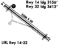
| Runways: | 14/32 |
| Longest Runway: | 14/32 is 3335 ft (1017 m) long |
| Runways with an Instrument Approach: |
7B2 Airport Runway Details
| Runway 14/32 | 3335 ft x 50 ft (1017 m x 15 m) | |
| Runway Length Source: | OWNER as of 10/22/2008 | |
| Surface: | Asphalt - Good condition - No special surface treatment | |
| Runway Edge Lights: | Medium Intensity | |
Runway Weight Bearing Capacity (in thousands of pounds) |
||
| Single Wheel Landing Gear: | 7.5 | |
Runway 14 |
Runway 32 |
|
Elevation: |
121.4 | 118.8 |
Latitude: |
42-19-50.8900N | 42-19-30.7800N |
Longitude: |
072-36-58.0500W | 072-36-22.8800W |
|
Runway True Alignment: |
128 | 308 |
Glide Path Angle: |
4.5 degrees | 0.0 degrees |
Traffic Pattern: |
Left | Left |
Runway Markings Type: |
Basic | Basic |
Runway Markings Condition: |
Good | Good |
Object at End: |
TREES | TREES |
Object Height: |
60 | 32 |
Distance from End: |
600 | 1000 |
Object Centerline Offset: |
210 ft. right of centerline | 51 ft. right of centerline |
Visual Glide Slope Indicators: |
4-Light PAPI On Left Side Of Runway | |
REIL: |
No | No |
Touchdown Lights: |
No | No |
Centerline Lights: |
No | No |
Threshold Crossing Height: |
60 | |
Threshold Elevation: |
119.3 | |
Displaced Threshold: |
220 | |
Threshold Latitude: |
42-19-32.1100N | |
Threshold Longitude: |
072-36-25.2000W |
Services
Airframe Repair: |
Major |
Powerplant Repair: |
Major |
Bottled Oxygen: |
None |
Bulk Oxygen: |
None |
Fuel Available: |
100LL, Jet A+ |
Landing Fees: |
No |
Parking: |
Tiedowns available |
Maps & Diagrams
7B2 Sectional
Flight Planning
at skyvector.com
at skyvector.com