Location
Latitude: |
48-34-26.4000N (48.574) |
Longitude: |
116-57-30.9000W (-116.958583) |
Elevation: |
2611.0 feet MSL (796 m MSL) |
Magnetic Variation: |
14.1 E (as of April 2024 from WMM2020 model) |
Time Zone: |
UTC -8.0 (Standard Time) UTC -7.0 (Daylight Savings Time) |
From City: |
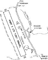
03 N.M. S of Nordman, Idaho |
Found On: |
Great Falls Chart |
FAA Region: |
ANM |
Contacts
Manager: |
Publicly owned: |
| JAMES GRASHAM - AVIATION OFFICER 11569 AIRPORT DR HAYDEN, ID 83835 208-762-6926 |
U.S. FOREST SERVICE P.O.BOX 7669 MISSOULA, MT 59807 406-329-3511 |
Operations
Airport Status: |
Operational |
Facility Use: |
Public |
Type: |
Airport |
Activation Date: |
08/1949 |
Control tower: |
No |
Attendance (Months/Days/Hours): |
Months/Days/Hours Unattended |
Boundary ARTCC: |
ZSE (Seattle) |
Responsible ARTCC: |
ZSE (Seattle) |
Segmented Circle Indicator: |
No |
Traffic Pattern Altitude (MSL): |
3611 feet (1101 m) |
NOTAMs Facility: |
BOI |
NOTAM-D Service: |
Yes |
Civil/Military Joint Use: |
No |
Based Aircraft
Annual Operations (as of 07/30/2022)
| Total Operations: | 1200 | |
| GA Itinerant: | 1200 | 100.0% |
Communications
| CTAF: | 122.900 |
Fixed Based Operators (FBOs) & Fuel
(Click on a business for detail)
Please help us keep this information up to date. This is a FREE SERVICE just like everything else on Airport Guide! If you see that a business needs to be added, modified, or deleted please fill out our Update Form.
To add, modify, or delete a business click here.
Please help us keep this information up to date. This is a FREE SERVICE just like everything else on Airport Guide! If you see that a business needs to be added, modified, or deleted please fill out our Update Form.
Area Code: 208 |
| Business Name | Frequency | Phone | Fuel Grade |
|---|
Flight Service Stations
| Primary | Alternate | |
| FSS on Field: | N | |
| FSS Name (ID): | Boise(BOI) | |
| Frequency: | ||
| Toll Free Phone: | 1-800-WX-BRIEF |
Instrument Procedures / Charts
Terminal Procedures are only available for airports in several countries with more being added all the time. If you are looking for a specific country's charts, please send an email to support(at)airportguide.com stating the country name. This will be used to prioritize the implementation.
Navigation Aids (Navaids) near 67S
| Dist (NM) | ID | Morse Code | Name | Type | Freq | True Hdg | Mag Hdg |
|---|---|---|---|---|---|---|---|
| 19.8 | ION | . . _ _ _ _ . | Ione | NDB | 379 | 294 | 280 |
| 23.2 | SZT | . . . _ _ . . _ | Sandpoe | NDB | 264 | 137 | 123 |
| 33.9 | U6 | Creston | NDB | 360 | 33 | 19 | |
| 38.7 | W6 | Creston North | NDB | 233 | 20 | 6 | |
| 40.9 | DPY | _ . . . _ _ . _ . _ _ | Deer Park | NDB | 365 | 207 | 193 |
| 48.3 | COE | _ . _ . _ _ _ . | Coeur D'alene | VOR-DME | 108.80 | 173 | 159 |
| 48.8 | EF | Champion | NDB | 206 | 327 | 313 | |
| 49.3 | XCG | Castlegar | DME | 110.10 | 325 | 311 | |
| 49.9 | LEN | . _ . . . _ . | Post Falls | NDB | 347 | 180 | 166 |
| 52.4 | YK | Brilliant | NDB | 269 | 329 | 315 | |
| 55.5 | SFF | . . . . . _ . . . _ . | Spokane/Felts Field | VOT | 114.00 | 195 | 181 |
| 57.3 | CRK | _ . _ . . _ . _ . _ | Canyon | NDB | 388 | 200 | 186 |
| 57.7 | CG | Castlegar | NDB | 227 | 335 | 321 | |
| 60.4 | LYI | . _ . . _ . _ _ . . | Libby | NDB | 414 | 104 | 90 |
| 62.0 | GEG | _ _ . . _ _ . | Spokane Intl | VOT | 109.60 | 201 | 187 |
| 63.7 | 2J | Grand Forks | NDB-DME | 250 | 295 | 281 | |
| 64.3 | SKA | . . . _ . _ . _ | Fairchild | TACAN | 111.40 | 206 | 192 |
| 66.2 | GEG | _ _ . . _ _ . | Spokane | VORTAC | 115.50 | 204 | 190 |
| 68.1 | YXC | _ . _ _ _ . . _ _ . _ . | Cranbrook | VOR-DME | 112.10 | 29 | 15 |
| 77.7 | IXC | Cranbrook | DME | 110.30 | 36 | 22 |
Nearby Airports with Fuel
Notices to Airmen (NOTAMS)
Remarks
| A110-1 | NO WINTER MAINTENANCE. |
| A110-2 | DO NOT PARK ACFT WITHIN 100 FT OF WX STATION. |
| A110-3 | USFS HELIPAD PRIVATE USE - LOCATED ON AIRPORT. |
| A110-4 | FOR CD CTC SEATTLE ARTCC AT 253-351-3694. |
| A32-14/32 | MAY NOT BE MOWED TO FULL WIDTH. |
| A42-14 | RWY 14/32 IS MKD ONLY WITH W CEMENT BDRY MKRS; THLDS MKD WITH CONC STRIPS. |
| A52-14 | +60' TREES AT 300' TO 1000' ON CNTRLN. |
| A52-32 | +14 FT ROAD 300 FT ON CNTRLN; 60 FT TREES 500 FT TO 1000 FT ON CNTRLN. |
| E111 | ARPT EXISTED PRIOR TO 15 MAY 59. |
Runways
Runway Summary
| Runways: | 14/32 |
| Longest Runway: | 14/32 is 4400 ft (1341 m) long |
| Runways with an Instrument Approach: |
67S Airport Runway Details
| Runway 14/32 | 4400 ft x 175 ft (1341 m x 53 m) | |
| Surface: | Turf/Gravel - Fair condition - No special surface treatment | |
Runway 14 |
Runway 32 |
|
Elevation: |
2611.0 | 2586.0 |
Latitude: |
48-34-47.0363N | 48-34-05.8081N |
Longitude: |
116-57-41.1647W | 116-57-20.6001W |
|
Runway True Alignment: |
162 | 342 |
Glide Path Angle: |
0.0 degrees | 0.0 degrees |
Traffic Pattern: |
Left | Left |
Object at End: |
TREES | ROAD |
Object Height: |
80 | 15 |
Distance from End: |
400 | 275 |
Object Centerline Offset: |
175 ft. left and right of centerline | 100 ft. left of centerline |
Services
Airframe Repair: |
Major |
Powerplant Repair: |
Major |
Bottled Oxygen: |
None |
Bulk Oxygen: |
None |
Fuel Available: |
100LL |
Landing Fees: |
No |
Parking: |
Tiedowns available |
Maps & Diagrams
67S Sectional
Flight Planning
at skyvector.com
at skyvector.com