Location
Latitude: |
48-31-07.2000N (48.518667) |
Longitude: |
116-49-19.9000W (-116.822194) |
Elevation: |
2484.0 feet MSL (757 m MSL) |
Magnetic Variation: |
14.1 E (as of April 2024 from WMM2020 model) |
Time Zone: |
UTC -8.0 (Standard Time) UTC -7.0 (Daylight Savings Time) |
From City: |
03 N.M. N of Coolin, Idaho |
Found On: |
Great Falls Chart |
FAA Region: |
ANM |
Contacts
Manager: |
Publicly owned: |
| DIVISION ADMIN BOX 7129 BOISE, ID 83707-1129 208-334-8775 |
STATE OF IDAHO/ITD-DIV OF AERO BOX 7129 BOISE, ID 83707-1129 208-334-8775 |
Operations
Airport Status: |
Operational |
Facility Use: |
Public |
Type: |
Airport |
Activation Date: |
09/1949 |
Control tower: |
No |
Attendance (Months/Days/Hours): |
Months/Days/Hours JUN-AUG/THU-MON/0800-1700 |
Boundary ARTCC: |
ZSE (Seattle) |
Responsible ARTCC: |
ZSE (Seattle) |
Segmented Circle Indicator: |
Yes |
Traffic Pattern Altitude (MSL): |
3484 feet (1062 m) |
NOTAMs Facility: |
BOI |
NOTAM-D Service: |
Yes |
Based Aircraft
Annual Operations (as of 06/30/2023)
| Total Operations: | 3500 | |
| GA Itinerant: | 3500 | 100.0% |
Communications
| CTAF: | 122.900 |
Fixed Based Operators (FBOs) & Fuel
(Click on a business for detail)
Please help us keep this information up to date. This is a FREE SERVICE just like everything else on Airport Guide! If you see that a business needs to be added, modified, or deleted please fill out our Update Form.
To add, modify, or delete a business click here.
Please help us keep this information up to date. This is a FREE SERVICE just like everything else on Airport Guide! If you see that a business needs to be added, modified, or deleted please fill out our Update Form.
Area Code: 208 |
| Business Name | Frequency | Phone | Fuel Grade |
|---|
Flight Service Stations
| Primary | Alternate | |
| FSS on Field: | N | |
| FSS Name (ID): | Boise(BOI) | |
| Frequency: | ||
| Toll Free Phone: | 1-800-WX-BRIEF |
Instrument Procedures / Charts
Terminal Procedures are only available for airports in several countries with more being added all the time. If you are looking for a specific country's charts, please send an email to support(at)airportguide.com stating the country name. This will be used to prioritize the implementation.
Navigation Aids (Navaids) near 66S
| Dist (NM) | ID | Morse Code | Name | Type | Freq | True Hdg | Mag Hdg |
|---|---|---|---|---|---|---|---|
| 17.1 | SZT | . . . _ _ . . _ | Sandpoe | NDB | 264 | 142 | 128 |
| 26.1 | ION | . . _ _ _ _ . | Ione | NDB | 379 | 296 | 282 |
| 34.3 | U6 | Creston | NDB | 360 | 23 | 9 | |
| 40.4 | W6 | Creston North | NDB | 233 | 12 | 358 | |
| 40.9 | DPY | _ . . . _ _ . _ . _ _ | Deer Park | NDB | 365 | 216 | 202 |
| 44.7 | COE | _ . _ . _ _ _ . | Coeur D'alene | VOR-DME | 108.80 | 179 | 165 |
| 46.9 | LEN | . _ . . . _ . | Post Falls | NDB | 347 | 186 | 172 |
| 54.1 | SFF | . . . . . _ . . . _ . | Spokane/Felts Field | VOT | 114.00 | 201 | 187 |
| 54.3 | LYI | . _ . . _ . _ _ . . | Libby | NDB | 414 | 103 | 89 |
| 54.6 | EF | Champion | NDB | 206 | 324 | 310 | |
| 55.1 | XCG | Castlegar | DME | 110.10 | 323 | 309 | |
| 56.4 | CRK | _ . _ . . _ . _ . _ | Canyon | NDB | 388 | 206 | 192 |
| 58.0 | YK | Brilliant | NDB | 269 | 326 | 312 | |
| 61.2 | GEG | _ _ . . _ _ . | Spokane Intl | VOT | 109.60 | 207 | 193 |
| 63.1 | CG | Castlegar | NDB | 227 | 332 | 318 | |
| 64.1 | SKA | . . . _ . _ . _ | Fairchild | TACAN | 111.40 | 212 | 198 |
| 65.7 | GEG | _ _ . . _ _ . | Spokane | VORTAC | 115.50 | 209 | 195 |
| 68.6 | YXC | _ . _ _ _ . . _ _ . _ . | Cranbrook | VOR-DME | 112.10 | 24 | 10 |
| 70.1 | 2J | Grand Forks | NDB-DME | 250 | 295 | 281 | |
| 73.8 | EUR | . . . _ . _ . | Eureka | NDB | 392 | 68 | 54 |
Nearby Airports with Fuel
Notices to Airmen (NOTAMS)
Remarks
| A110-1 | NO WINTER MAINTENANCE. |
| A110-2 | RWY 15/33 NO LINE OF SIGHT BTN RWY ENDS. |
| A110-3 | WATCH FOR SPRINKLERS ON RY. |
| A110-4 | ARPT ATTENDED BY CARETAKER DURG SUMMER MONTHS. |
| A110-5 | SEAPLANE OPERATIONS CONDUCTED IN BAY NORTH & ADJACENT TO ARPT; MONITOR CTAF. |
| A110-6 | HEAVY SNOWMOBILES ACTIVITY DURING WINTER MONTHS. |
| A110-7 | FOR CD CTC SEATTLE ARTCC AT 253-351-3694. |
| A42-15 | 15/33 EDGES & THRS MKD WITH WHITE ROCKS. |
| A52-15 | RY 15 +100 FT TREE 310 FT FM RY END 150 FT R; +12 FT ROAD 40 FT ON CNTRLN; +120 FT TREE 200 FT FM RY END 180 FT L; +30 FT TREE 125 FT FM RY END ON CNTRLN; +25 FT BLDG AT 90 FT; 60 FT L. |
| A57-15 | BOTH RWY ENDS HAVE 50-70 FT TALL TREES. AFCTS EITHER APCH OR DEP. |
| E111 | ARPT EXISTED PRIOR TO 15 MAY 59. |
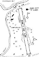
Runways
Runway Summary
| Runways: | 15/33 |
| Longest Runway: | 15/33 is 3100 ft (945 m) long |
| Runways with an Instrument Approach: |
66S Airport Runway Details
| Runway 15/33 | 3100 ft x 120 ft (945 m x 37 m) | |
| Surface: | Turf - Good condition - No special surface treatment | |
Runway 15 |
Runway 33 |
|
Elevation: |
2454.0 | |
Latitude: |
48-31-22.2300N | 48-30-52.1500N |
Longitude: |
116-49-23.9800W | 116-49-15.8100W |
Glide Path Angle: |
0.0 degrees | 0.0 degrees |
Traffic Pattern: |
Right | Left |
Object at End: |
TREE | TREE |
Object Height: |
85 | 65 |
Distance from End: |
0 | 0 |
Object Centerline Offset: |
90 ft. right of centerline | 95 ft. left of centerline |
Services
Airframe Repair: |
None |
Powerplant Repair: |
None |
Bottled Oxygen: |
None |
Bulk Oxygen: |
None |
Fuel Available: |
Mogas |
Landing Fees: |
No |
Parking: |
Tiedowns available |
Maps & Diagrams
66S Sectional
Flight Planning
at skyvector.com
at skyvector.com