Location
Latitude: |
44-12-30.8000N (44.208556) |
Longitude: |
114-56-04.3000W (-114.934528) |
Elevation: |
6403.0 feet MSL (1952 m MSL) |
Magnetic Variation: |
12.6 E (as of April 2024 from WMM2020 model) |
Time Zone: |
UTC -7.0 (Standard Time) UTC -6.0 (Daylight Savings Time) |
From City: |
01 N.M. SE of Stanley, Idaho |
Found On: |
Salt Lake City Chart |
FAA Region: |
ANM |
Contacts
Manager: |
Publicly owned: |
| DIV OF AERONAUTICS P O BOX 7129 BOISE, ID 83707-1129 208-334-8775 |
STATE OF IDAHO/ITD - AERONAUTICS PO BOX 7129 BOISE, ID 83707-1129 208-334-8775 |
Operations
Airport Status: |
Operational |
Facility Use: |
Public |
Type: |
Airport |
Activation Date: |
02/1954 |
Control tower: |
No |
Attendance (Months/Days/Hours): |
Months/Days/Hours Unattended |
Boundary ARTCC: |
ZLC (Salt Lake City) |
Responsible ARTCC: |
ZLC (Salt Lake City) |
Segmented Circle Indicator: |
Yes |
Traffic Pattern Altitude (MSL): |
7403 feet (2256 m) |
NOTAMs Facility: |
BOI |
NOTAM-D Service: |
Yes |
International Airport of Entry: |
No |
Customs Landing Rights: |
No |
Based Aircraft
| Single Engine: | 4 |
Annual Operations (as of 08/31/2021)
| Total Operations: | 2700 | |
| Air Taxi: | 1800 | 66.7% |
| GA Local: | 100 | 3.7% |
| GA Itinerant: | 800 | 29.6% |
Communications
| CTAF: | 122.900 |
Fixed Based Operators (FBOs) & Fuel
(Click on a business for detail)
Please help us keep this information up to date. This is a FREE SERVICE just like everything else on Airport Guide! If you see that a business needs to be added, modified, or deleted please fill out our Update Form.
To add, modify, or delete a business click here.
Please help us keep this information up to date. This is a FREE SERVICE just like everything else on Airport Guide! If you see that a business needs to be added, modified, or deleted please fill out our Update Form.
Area Code: 208 |
| Business Name | Frequency | Phone | Fuel Grade |
|---|---|---|---|
| Stanley Air Taxi
Update FBO info |
774-2276 | 100LL |
Flight Service Stations
| Primary | Alternate | |
| FSS on Field: | N | |
| FSS Name (ID): | Boise(BOI) | |
| Frequency: | ||
| Toll Free Phone: | 1-800-WX-BRIEF |
Instrument Procedures / Charts
Terminal Procedures are only available for airports in several countries with more being added all the time. If you are looking for a specific country's charts, please send an email to support(at)airportguide.com stating the country name. This will be used to prioritize the implementation.
Navigation Aids (Navaids) near 2U7
| Dist (NM) | ID | Morse Code | Name | Type | Freq | True Hdg | Mag Hdg |
|---|---|---|---|---|---|---|---|
| 60.6 | HLE | . . . . . _ . . . | Hailey | NDB-DME | 220 | 150 | 138 |
| 60.8 | LKT | . _ . . _ . _ _ | Salmon | VOR-DME | 113.50 | 36 | 24 |
| 63.9 | DNJ | _ . . _ . . _ _ _ | Donnelly | VOR-DME | 116.20 | 302 | 289 |
| 67.1 | BOI | _ . . . _ _ _ . . | Boise | VORTAC | 113.30 | 234 | 221 |
| 68.0 | BOI | _ . . . _ _ _ . . | Boise | VOT | 116.70 | 235 | 222 |
| 70.1 | BO | _ . . . _ _ _ | Ustik | NDB | 359 | 238 | 225 |
| 72.8 | STI | . . . _ . . | Sturgeon | NDB | 333 | 205 | 192 |
| 78.3 | MPA | _ _ . _ _ . . _ | Meridian | NDB | 238 | 242 | 229 |
| 78.4 | HDG | . . . . _ . . _ _ . | Steelhead | NDB | 211 | 171 | 159 |
| 81.1 | MUO | _ _ . . _ _ _ _ | Mountain Home | TACAN | 114.00 | 210 | 197 |
| 82.1 | LIA | . _ . . . . . _ | Liberator | VOR | 114.90 | 206 | 193 |
| 90.0 | ONO | _ _ _ _ . _ _ _ | Ontario | NDB | 305 | 263 | 250 |
Nearby Airports with Fuel
Notices to Airmen (NOTAMS)
Remarks
| A10 | STAN HARRAH LEASES A PORTION OF ARPT PROPERTY FROM US GOVT. |
| A110-1 | NO WINTER MAINTENANCE. |
| A110-2 | ARPT LCTD IN VALLEY SURROUNDED BY HIGH MOUNTAINOUS TRRN. |
| A110-3 | NUMEROUS AIR TAXI OPNS DURG SUMMER MONTHS. |
| A110-4 | FOR CD CTC SALT LAKE ARTCC AT 801-320-2568. |
| A31-17/35 | RWY 17/35 1600 FT X 30 FT ASPH ON RWY 17 END, REMAINDER DIRT. |
| A42-17 | 17/35 RY EDGES AND THRS MARKED WITH WHITE ROCKS. |
| A84 | SEGMENTED CIRCLE NORTH END NSTD. |
| A90 | ACFT BASED AT ARPT DURING SUMMER MONTHS ONLY. |
| E111 | ESTABD PRIOR TO 1959. |
Runways
Runway Summary
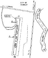
| Runways: | 17/35 |
| Longest Runway: | 17/35 is 4300 ft (1311 m) long |
| Runways with an Instrument Approach: |
2U7 Airport Runway Details
| Runway 17/35 | 4300 ft x 150 ft (1311 m x 46 m) | |
| Surface: | Asphalt/Dirt - Good condition - No special surface treatment | |
Runway 17 |
Runway 35 |
|
Elevation: |
6403.0 | 6395.0 |
Latitude: |
44-12-51.5300N | 44-12-10.0000N |
Longitude: |
114-55-58.1500W | 114-56-10.5400W |
|
Runway True Alignment: |
192 | 012 |
Glide Path Angle: |
0.0 degrees | 0.0 degrees |
Traffic Pattern: |
Left | Left |
Runway Markings Type: |
Nonstandard (other than numbers only) | |
Object at End: |
TREES | FENCE |
Object Height: |
15 | 5 |
Distance from End: |
170 | 0 |
Object Centerline Offset: |
60 ft. right of centerline | 80 ft. right of centerline |
Services
Airframe Repair: |
Major |
Powerplant Repair: |
Major |
Bottled Oxygen: |
None |
Bulk Oxygen: |
None |
Fuel Available: |
100LL, MOGAS |
Landing Fees: |
No |
Parking: |
Tiedowns available |
Maps & Diagrams
2U7 Sectional
Flight Planning
at skyvector.com
at skyvector.com