Location
Latitude: |
44-27-40.6000N (44.461278) |
Longitude: |
116-45-28.9000W (-116.758028) |
Elevation: |
2617.0 feet MSL (798 m MSL) |
Magnetic Variation: |
13.2 E (as of April 2024 from WMM2020 model) |
Time Zone: |
UTC -7.0 (Standard Time) UTC -6.0 (Daylight Savings Time) |
From City: |
01 N.M. SW of Midvale, Idaho |
Found On: |
Salt Lake City Chart |
FAA Region: |
ANM |
Contacts
Manager: |
Publicly owned: |
| KARSON CRAIG 350 SCHOOL RD MIDVALE, ID 83645 208-355-2391 |
CITY OF MIDVALE P O BOX 115 MIDVALE, ID 83645 208-355-2221 |
Operations
Airport Status: |
Operational |
Facility Use: |
Public |
Type: |
Airport |
Activation Date: |
05/1947 |
Control tower: |
No |
Attendance (Months/Days/Hours): |
Months/Days/Hours Unattended |
Boundary ARTCC: |
ZLC (Salt Lake City) |
Responsible ARTCC: |
ZLC (Salt Lake City) |
Segmented Circle Indicator: |
No |
Traffic Pattern Altitude (MSL): |
3617 feet (1102 m) |
NOTAMs Facility: |
BOI |
NOTAM-D Service: |
Yes |
Civil/Military Joint Use: |
No |
Based Aircraft
| Single Engine: | 2 |
Annual Operations (as of 03/30/2023)
| Total Operations: | 2000 | |
| GA Local: | 250 | 12.5% |
| GA Itinerant: | 1750 | 87.5% |
Communications
| CTAF: | 122.900 |
- COMMUNICATIONS PRVDD BY BOISE RADIO ON FREQ 122.5 (CASCADE RCO).
Fixed Based Operators (FBOs) & Fuel
(Click on a business for detail)
Please help us keep this information up to date. This is a FREE SERVICE just like everything else on Airport Guide! If you see that a business needs to be added, modified, or deleted please fill out our Update Form.
To add, modify, or delete a business click here.
Please help us keep this information up to date. This is a FREE SERVICE just like everything else on Airport Guide! If you see that a business needs to be added, modified, or deleted please fill out our Update Form.
Area Code: 208 |
| Business Name | Frequency | Phone | Fuel Grade |
|---|
Flight Service Stations
| Primary | Alternate | |
| FSS on Field: | N | |
| FSS Name (ID): | Boise(BOI) | |
| Frequency: | ||
| Toll Free Phone: | 1-800-WX-BRIEF |
Instrument Procedures / Charts
Terminal Procedures are only available for airports in several countries with more being added all the time. If you are looking for a specific country's charts, please send an email to support(at)airportguide.com stating the country name. This will be used to prioritize the implementation.
Navigation Aids (Navaids) near 0U9
| Dist (NM) | ID | Morse Code | Name | Type | Freq | True Hdg | Mag Hdg |
|---|---|---|---|---|---|---|---|
| 28.6 | ONO | _ _ _ _ . _ _ _ | Ontario | NDB | 305 | 202 | 189 |
| 29.9 | DNJ | _ . . _ . . _ _ _ | Donnelly | VOR-DME | 116.20 | 51 | 38 |
| 50.3 | BKE | _ . . . _ . _ . | Baker City | VOR-DME | 115.30 | 297 | 284 |
| 52.3 | MPA | _ _ . _ _ . . _ | Meridian | NDB | 238 | 169 | 156 |
| 55.3 | BO | _ . . . _ _ _ | Ustik | NDB | 359 | 159 | 146 |
| 59.1 | BOI | _ . . . _ _ _ . . | Boise | VOT | 116.70 | 156 | 143 |
| 59.7 | BOI | _ . . . _ _ _ . . | Boise | VORTAC | 113.30 | 155 | 142 |
| 73.6 | LGD | . _ . . _ _ . _ . . | La Grande | NDB | 296 | 316 | 303 |
| 93.4 | MUO | _ _ . . _ _ _ _ | Mountain Home | TACAN | 114.00 | 155 | 142 |
| 93.9 | STI | . . . _ . . | Sturgeon | NDB | 333 | 149 | 136 |
| 97.0 | IDQ | . . _ . . _ _ . _ | Cottonwood | DME | 115.65 | 7 | 354 |
| 98.4 | LIA | . _ . . . . . _ | Liberator | VOR | 114.90 | 153 | 140 |
Nearby Airports with Fuel
Notices to Airmen (NOTAMS)
Remarks
| A110-1 | NO WINTER MAINT, ARPT CLSD WHEN SNOW CONDS DICTATE. |
| A110-2 | FOR CD CTC SALT LAKE ARTCC AT 801-320-2568. |
| A30-08/26 | 250 FT OVRN EACH END. |
| A33-08/26 | ENTR RWY IS COVD IN NMRS 2-3 IN WIDE CRACKS BOTH LONGL BUT MSTLY TRANSVERSELY. MOST OF THE SLURRY FILL APPLIED PREVLY IS SHRINKING DOWN LVG +2 IN DEEP GAPS PRSNT ON THE RWY. |
| A52-26 | +35 FT BLDG AT 400 FT 200 FT L; +150 FT PLINE AT 5000 FT ON CNTRLN. |
| E111 | ESTABD PRIOR TO 15 MAY 1959. |
Runways
Runway Summary
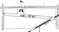
| Runways: | 08/26 |
| Longest Runway: | 08/26 is 2875 ft (876 m) long |
| Runways with an Instrument Approach: |
0U9 Airport Runway Details
| Runway 08/26 | 2875 ft x 60 ft (876 m x 18 m) | |
| Runway Length Source: | OWNER as of 07/19/2008 | |
| Surface: | Asphalt - Poor condition - No special surface treatment | |
Runway 08 |
Runway 26 |
|
Elevation: |
2617.0 | 2594.0 |
Latitude: |
44-27-41.3593N | 44-27-39.7680N |
Longitude: |
116-45-48.6619W | 116-45-09.0736W |
|
Runway True Alignment: |
093 | 273 |
Glide Path Angle: |
0.0 degrees | 0.0 degrees |
Traffic Pattern: |
Left | Left |
Runway Markings Type: |
Numbers Only | Numbers Only |
Runway Markings Condition: |
Fair | Fair |
Object at End: |
FENCE | FENCE |
Object Height: |
4 | 4 |
Distance from End: |
250 | 0 |
Object Centerline Offset: |
0 ft. left and right of centerline | 60 ft. left of centerline |
Services
Airframe Repair: |
None |
Powerplant Repair: |
None |
Bottled Oxygen: |
None |
Bulk Oxygen: |
None |
Fuel Available: |
100LL |
Landing Fees: |
No |
Parking: |
Tiedowns available |
Maps & Diagrams
0U9 Sectional
Flight Planning
at skyvector.com
at skyvector.com