Location
Latitude: |
42-55-00.0430N (42.916679) |
Longitude: |
097-23-09.3540W (-97.385932) |
Elevation: |
1305.9 feet MSL (398 m MSL) |
Magnetic Variation: |
3.1 E (as of April 2024 from WMM2020 model) |
Time Zone: |
UTC -6.0 (Standard Time) UTC -5.0 (Daylight Savings Time) |
From City: |
03 N.M. N of Yankton, South Dakota |
Found On: |
Omaha Chart |
FAA Region: |
AGL |
Contacts
Manager: |
Publicly owned: |
| MIKE ROINSTAD 700 EAST 31ST STREET YANKTON, SD 57078 605-661-9223 |
CITY OF YANKTON PO BOX 176 YANKTON, SD 57078 605-668-5288 |
Operations
Airport Status: |
Operational |
Facility Use: |
Public |
Type: |
Airport |
Activation Date: |
12/1937 |
Control tower: |
No |
Attendance (Months/Days/Hours): |
Months/Days/Hours ALL/MON-FRI/0800-1700 |
Boundary ARTCC: |
ZMP (Minneapolis) |
Responsible ARTCC: |
ZMP (Minneapolis) |
Lighting Schedule: |
SEE RMK |
Segmented Circle Indicator: |
Yes |
Traffic Pattern Altitude (MSL): |
2306 feet (703 m) |
NOTAMs Facility: |
YKN |
NOTAM-D Service: |
Yes |
International Airport of Entry: |
No |
Customs Landing Rights: |
No |
Military Landing Rights: |
Yes |
Civil/Military Joint Use: |
No |
Based Aircraft
| Single Engine: | 25 |
Annual Operations (as of 04/11/2023)
| Total Operations: | 7832 | |
| Air Taxi: | 120 | 1.5% |
| GA Local: | 6500 | 83.0% |
| GA Itinerant: | 1200 | 15.3% |
| Military Aircraft: | 12 | 0.2% |
Communications
| CTAF: | 122.800 |
| Unicom: | 122.800 |
| AWOS-3PT: | 119.05 (605-665-6072) |
- APCH/DEP SVC PRVDD BY MINNEAPOLIS ARTCC ON FREQS 125.025/235.625 (SIOUX CITY RCAG).
Fixed Based Operators (FBOs) & Fuel
(Click on a business for detail)
Please help us keep this information up to date. This is a FREE SERVICE just like everything else on Airport Guide! If you see that a business needs to be added, modified, or deleted please fill out our Update Form.
To add, modify, or delete a business click here.
Please help us keep this information up to date. This is a FREE SERVICE just like everything else on Airport Guide! If you see that a business needs to be added, modified, or deleted please fill out our Update Form.
Area Code: 605 |
| Business Name | Frequency | Phone | Fuel Grade |
|---|---|---|---|
| Falcon Aviation
Update FBO info |
Unicom 122.8 | 665-3473 | 100LL, Jet A |
Flight Service Stations
| Primary | Alternate | |
| FSS on Field: | N | |
| FSS Name (ID): | Huron(HON) | |
| Frequency: | ||
| Toll Free Phone: | 1-800-WX-BRIEF |
Instrument Procedures / Charts
FAA Terminal Procedures valid from 0901Z 03/21/24 to 0901Z 04/18/24.
There are various types of charts available for an airport. They are listed in the Page Type column. Here is a legend for those types:
APD - Airport Diagram
DP - Departure Procedure Charts
HOT - Hot Spots
IAP - Instrument Approach Procedure Charts
MIN - Minimums
STAR - Standard Terminal Arrival Charts
| Page Type | Page Name | Volume | Action Since Last Cycle |
|---|---|---|---|
| IAP | ILS OR LOC RWY 31 | NC-1 | |
| IAP | RNAV (GPS) RWY 13 | NC-1 | |
| IAP | RNAV (GPS) RWY 31 | NC-1 | |
| MIN | ALTERNATE MINIMUMS | NC-1 | |
| MIN | TAKEOFF MINIMUMS | NC-1 |
Terminal Procedures are only available for airports in several countries with more being added all the time. If you are looking for a specific country's charts, please send an email to support(at)airportguide.com stating the country name. This will be used to prioritize the implementation.
Navigation Aids (Navaids) near YKN
| Dist (NM) | ID | Morse Code | Name | Type | Freq | True Hdg | Mag Hdg |
|---|---|---|---|---|---|---|---|
| 0.1 | YKN | _ . _ _ _ . _ _ . | Yankton | DME | 111.4 | 21 | 18 |
| 5.7 | YK | _ . _ _ _ . _ | Cagur | NDB | 347 | 139 | 136 |
| 40.8 | AGZ | . _ _ _ . _ _ . . | Wagner | NDB | 392 | 282 | 279 |
| 42.3 | FS | . . _ . . . . | Rokky | NDB | 245 | 34 | 31 |
| 49.1 | OI | _ _ _ . . | Tommi | NDB | 305 | 123 | 120 |
| 51.3 | FSD | . . _ . . . . _ . . | Sioux Falls | VORTAC | 115.00 | 30 | 27 |
| 53.6 | GAK | _ _ . . _ _ . _ | Sioux Gateway | NDB | 233 | 124 | 121 |
| 54.1 | SOY | . . . _ _ _ _ . _ _ | Sioux Center | NDB | 368 | 75 | 72 |
| 55.8 | OFK | _ _ _ . . _ . _ . _ | Norfolk | VOR-DME | 109.60 | 182 | 179 |
| 58.1 | SUX | . . . . . _ _ . . _ | Sioux City | TACAN | 116.50 | 125 | 122 |
| 58.4 | ORC | _ _ _ . _ . _ . _ . | Orange City | NDB | 521 | 85 | 82 |
| 58.9 | MHE | _ _ . . . . . | Mitchell | VOR-DME | 109.20 | 331 | 328 |
| 59.9 | SU | . . . . . _ | Salix | NDB | 414 | 125 | 122 |
| 61.9 | OF | _ _ _ . . _ . | Carsy | NDB | 510 | 183 | 180 |
| 63.3 | ONL | _ _ _ _ . . _ . . | O'neill | VORTAC | 113.90 | 245 | 241 |
| 67.1 | MDS | _ _ _ . . . . . | Wentworth | NDB | 400 | 11 | 8 |
| 70.3 | SHL | . . . . . . . . _ . . | Sheldon | NDB | 338 | 74 | 71 |
| 76.5 | ISB | . . . . . _ . . . | Sibley | NDB | 269 | 68 | 66 |
| 77.1 | BVN | _ . . . . . . _ _ . | Alaby | NDB | 332 | 202 | 199 |
| 83.1 | MEY | _ _ . _ . _ _ | Mapleton | NDB | 335 | 121 | 118 |
Nearby Airports with Fuel
Notices to Airmen (NOTAMS)
Remarks
| A110-1 | MIGRATORY WATERFOWL ON & INVOF ARPT. |
| A110-2 | PAEW MOWING SEASONAL. |
| A110-4 | FOR CD CTC MINNEAPOLIS ARTCC AT 651-463-5588. |
| A17 | FOR SVC AFT 1700 CALL 605-661-9223. |
| A81-APT | ACTVT MALSR RWY 31; REILS RWY 13; PAPI RWY 02 & 20; HIRL RWY 13/31; MIRL RWY 02/20 - CTAF. |
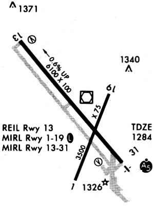
Runways
Runway Summary
| Runways: | 02/20 13/31 |
| Longest Runway: | 13/31 is 6094 ft (1857 m) long |
| Runways with an Instrument Approach: | 31 |
YKN Airport Runway Details
| Runway 02/20 | 3380 ft x 60 ft (1030 m x 18 m) | |
| Runway Length Source: | 3RD PARTY SURVEY as of 09/28/2020 | |
| Surface: | Asphalt - Excellent condition - No special surface treatment | |
| Runway Edge Lights: | Medium Intensity | |
Runway Weight Bearing Capacity (in thousands of pounds) |
||
| Single Wheel Landing Gear: | 12.5 | |
Runway 02 |
Runway 20 |
|
Elevation: |
1273.6 | 1281.7 |
Latitude: |
42-54-36.4641N | 42-55-07.5381N |
Longitude: |
097-23-10.7033W | 097-22-54.1098W |
|
Runway True Alignment: |
021 | 201 |
Glide Path Angle: |
3.0 degrees | 3.0 degrees |
Traffic Pattern: |
Left | Left |
Runway Markings Type: |
Nonprecision Instrument | Nonprecision Instrument |
Runway Markings Condition: |
Good | Good |
Object at End: |
PLINE | FENCE |
Object Height: |
7 | 6 |
Object Marked/Lighted?: |
Marked | |
Distance from End: |
385 | 382 |
Object Centerline Offset: |
94 ft. right of centerline | 11 ft. right of centerline |
Visual Glide Slope Indicators: |
2-Light PAPI On Left Side Of Runway | 2-Light PAPI On Left Side Of Runway |
REIL: |
No | No |
Touchdown Lights: |
No | No |
Centerline Lights: |
No | No |
Threshold Crossing Height: |
25 | 25 |
| Runway 13/31 | 6094 ft x 100 ft (1857 m x 30 m) | |
| Runway Length Source: | 3RD PARTY SURVEY as of 09/28/2020 | |
| Surface: | Asphalt - Excellent condition - No special surface treatment | |
| Runway Edge Lights: | High Intensity | |
Runway Weight Bearing Capacity (in thousands of pounds) |
||
| Single Wheel Landing Gear: | 30.0 | |
| Dual Wheel Landing Gear: | 50.0 | |
| Dual Tandem Wheel Landing Gear: | 90.0 | |
Runway 13 |
Runway 31 |
|
Elevation: |
1305.9 | 1270.6 |
Latitude: |
42-55-27.4721N | 42-54-41.5326N |
Longitude: |
097-23-39.6678W | 097-22-46.7520W |
|
Runway True Alignment: |
140 | 320 |
ILS Type: |
ILS | |
Glide Path Angle: |
3.0 degrees | 3.0 degrees |
Traffic Pattern: |
Left | Left |
Runway Markings Type: |
Precision Instrument | Precision Instrument |
Runway Markings Condition: |
Good | Good |
Object Centerline Offset: |
94 ft. right of centerline | 11 ft. right of centerline |
Visual Glide Slope Indicators: |
4-Box VASI On Left Side Of Runway | 4-Box VASI On Left Side Of Runway |
Approach Light System: |
1,400 Foot Medium Intensity Approach Lighting System With Runway Alignment Indicator Lights | |
REIL: |
Yes | |
Touchdown Lights: |
No | No |
Centerline Lights: |
No | No |
Threshold Crossing Height: |
41 | 48 |
Services
Airframe Repair: |
Major |
Powerplant Repair: |
Major |
Fuel Available: |
100LL, Jet A |
Landing Fees: |
No |
Parking: |
Hangars and tiedowns available |
Maps & Diagrams
YKN Sectional
Flight Planning
at skyvector.com
at skyvector.com