Location
Latitude: |
43-01-16.5854N (43.021274) |
Longitude: |
102-30-23.7831W (-102.506606) |
Elevation: |
3332.5 feet MSL (1016 m MSL) |
Magnetic Variation: |
6.5 E (as of April 2024 from WMM2020 model) |
Time Zone: |
UTC -7.0 (Standard Time) UTC -6.0 (Daylight Savings Time) |
From City: |
02 N.M. E of Pine Ridge, South Dakota |
Found On: |
Cheyenne Chart |
FAA Region: |
AGL |
Contacts
Manager: |
Publicly owned: |
| DAVID RABBIT P.O. BOX 3044 PINE RIDGE, SD 57770 605-867-5580 |
OGLALA SIOUX TRIBE PO BOX 3044 PINE RIDGE, SD 57770 605-867-5580 |
Operations
Airport Status: |
Operational |
Facility Use: |
Public |
Type: |
Airport |
Activation Date: |
05/1961 |
Control tower: |
No |
Attendance (Months/Days/Hours): |
Months/Days/Hours Unattended |
Boundary ARTCC: |
ZDV (Denver) |
Responsible ARTCC: |
ZDV (Denver) |
Lighting Schedule: |
SEE RMK |
Segmented Circle Indicator: |
No |
Traffic Pattern Altitude (MSL): |
4332 feet (1320 m) |
NOTAMs Facility: |
IEN |
NOTAM-D Service: |
Yes |
International Airport of Entry: |
No |
Customs Landing Rights: |
No |
Military Landing Rights: |
Yes |
Civil/Military Joint Use: |
No |
Based Aircraft
Annual Operations (as of 04/26/2023)
| Total Operations: | 2400 | |
| GA Itinerant: | 2400 | 100.0% |
Communications
| CTAF: | 122.900 |
| ASOS: | 126.775 (605-867-1584) |
- APCH/DEP CTL SVC PRVDD BY DENVER ARTCC (ZDV) ON FREQS 127.95/338.2 (CRAWFORD RCAG).
Fixed Based Operators (FBOs) & Fuel
(Click on a business for detail)
Please help us keep this information up to date. This is a FREE SERVICE just like everything else on Airport Guide! If you see that a business needs to be added, modified, or deleted please fill out our Update Form.
To add, modify, or delete a business click here.
Please help us keep this information up to date. This is a FREE SERVICE just like everything else on Airport Guide! If you see that a business needs to be added, modified, or deleted please fill out our Update Form.
Area Code: 605 |
| Business Name | Frequency | Phone | Fuel Grade |
|---|
Flight Service Stations
| Primary | Alternate | |
| FSS on Field: | N | |
| FSS Name (ID): | Huron(HON) | |
| Frequency: | ||
| Toll Free Phone: | 1-800-WX-BRIEF |
Instrument Procedures / Charts
FAA Terminal Procedures valid from 0901Z 03/21/24 to 0901Z 04/18/24.
There are various types of charts available for an airport. They are listed in the Page Type column. Here is a legend for those types:
APD - Airport Diagram
DP - Departure Procedure Charts
HOT - Hot Spots
IAP - Instrument Approach Procedure Charts
MIN - Minimums
STAR - Standard Terminal Arrival Charts
| Page Type | Page Name | Volume | Action Since Last Cycle |
|---|---|---|---|
| IAP | RNAV (GPS) RWY 12 | NC-1 | |
| IAP | RNAV (GPS) RWY 30 | NC-1 | |
| MIN | ALTERNATE MINIMUMS | NC-1 | |
| MIN | TAKEOFF MINIMUMS | NC-1 |
Terminal Procedures are only available for airports in several countries with more being added all the time. If you are looking for a specific country's charts, please send an email to support(at)airportguide.com stating the country name. This will be used to prioritize the implementation.
Navigation Aids (Navaids) near XPR
| Dist (NM) | ID | Morse Code | Name | Type | Freq | True Hdg | Mag Hdg |
|---|---|---|---|---|---|---|---|
| 19.5 | GRN | _ _ . . _ . _ . | Gordon | NDB | 414 | 132 | 126 |
| 28.3 | HIN | . . . . . . _ . | Whitney | NDB | 275 | 246 | 239 |
| 33.4 | CD | _ . _ . _ . . | Dawes | NDB | 362 | 241 | 234 |
| 45.0 | TST | _ . . . _ | Toadstool | VOR-DME | 113.40 | 232 | 225 |
| 59.4 | AIA | . _ . . . _ | Alliance | VOR-DME | 111.80 | 192 | 185 |
| 60.1 | ALU | . _ . _ . . . . _ | Alliance | NDB | 380 | 192 | 185 |
| 60.5 | RA | . _ . . _ | Ranch | NDB | 254 | 339 | 332 |
| 61.4 | RAP | . _ . . _ . _ _ . | Rapid City | VORTAC | 112.30 | 339 | 332 |
| 71.9 | RCA | . _ . _ . _ . . _ | Ellsworth | TACAN | 108.80 | 339 | 332 |
| 72.2 | PHP | . _ _ . . . . . . _ _ . | Philip | VOR-DME | 108.40 | 30 | 24 |
| 80.2 | BFF | _ . . . . . _ . . . _ . | Scottsbluff | VORTAC | 112.60 | 212 | 205 |
| 85.3 | BF | _ . . . . . _ . | Creve | NDB | 263 | 211 | 204 |
| 86.5 | VTN | . . . _ _ _ . | Valentine | NDB | 314 | 95 | 89 |
| 92.7 | TOR | _ _ _ _ . _ . | Torrington | NDB | 293 | 232 | 225 |
| 93.9 | ECS | . _ . _ . . . . | Newcastle | VOR | 108.20 | 303 | 296 |
| 97.5 | OKS | _ _ _ _ . _ . . . | Oshkosh | NDB | 233 | 175 | 169 |
Nearby Airports with Fuel
| Dist (NM) | Name (Airport IDs) | True Hdg | Mag Hdg | Fuel Grade |
|---|---|---|---|---|
| 19.5 | Gordon Municipal Airport (GRN KGRN GRN) |
131 | 125 | 100LL |
| 28.1 | Chadron Municipal Airport (CDR KCDR CDR) |
247 | 240 | 100LL, Jet A |
| 43.8 | Hot Springs Municipal Airport (KHSR HSR) |
298 | 291 | 100LL |
| 59.6 | Alliance Municipal Airport (AIA KAIA AIA) |
192 | 185 | 100LL, Jet A |
| 65.9 | Rapid City Regional Airport (RAP KRAP RAP) |
338 | 331 | 100LL, Jet A |
| 68.9 | Grant County Airport (1V2) |
151 | 145 | 100LL |
| 73.2 | Philip Airport (PHP KPHP PHP) |
32 | 26 | 100LL |
| 84.0 | Western Nebraska Regional/William B Heilig Field Airport (BFF KBFF BFF) |
215 | 208 | 100LL, Jet A |
| 85.0 | Lusk Municipal Airport (LSK KLSK LSK) |
259 | 251 | 100LL |
| 86.6 | Miller Field Airport (VTN KVTN VTN) |
95 | 90 | 100LL, Jet A |
| 92.0 | Sturgis Municipal Airport (49B) |
336 | 329 | 100LL, Jet A |
| 92.7 | Torrington Municipal Airport (TOR KTOR TOR) |
232 | 225 | 100LL, Jet A+ |
| 94.2 | Mondell Field Airport (ECS KECS ECS) |
303 | 295 | 100LL, Jet A |
Notices to Airmen (NOTAMS)
Remarks
| A110-2 | FOR CD CTC DENVER ARTCC AT 303-651-4257. |
| A81-APT | MIRL RY 12/30 AND PAPI RY 30 OPER DUSK-2230; AFT 2230 ACTVT - CTAF. |
Runways
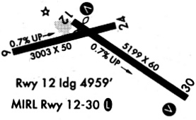
Runway Summary
| Runways: | 12/30 |
| Longest Runway: | 12/30 is 5000 ft (1524 m) long |
| Runways with an Instrument Approach: |
XPR Airport Runway Details
| Runway 12/30 | 5000 ft x 75 ft (1524 m x 23 m) | |
| Runway Length Source: | 3RD PARTY SURVEY as of 09/15/2011 | |
| Surface: | Asphalt - Good condition - No special surface treatment | |
| Runway Edge Lights: | Medium Intensity | |
Runway Weight Bearing Capacity (in thousands of pounds) |
||
| Single Wheel Landing Gear: | 12.0 | |
Runway 12 |
Runway 30 |
|
Elevation: |
3299.6 | 3332.5 |
Latitude: |
43-01-32.0019N | 43-01-01.1688N |
Longitude: |
102-30-50.0625W | 102-29-57.5036W |
|
Runway True Alignment: |
129 | 309 |
Glide Path Angle: |
0.0 degrees | 3.0 degrees |
Traffic Pattern: |
Left | Left |
Runway Markings Type: |
Nonprecision Instrument | Nonprecision Instrument |
Runway Markings Condition: |
Good | Good |
Object at End: |
PLINE | FENCE |
Object Height: |
29 | 3 |
Distance from End: |
841 | 300 |
Object Centerline Offset: |
0 ft. left and right of centerline | 0 ft. left and right of centerline |
Visual Glide Slope Indicators: |
2-Light PAPI On Left Side Of Runway | |
REIL: |
No | No |
Touchdown Lights: |
No | No |
Centerline Lights: |
No | No |
Threshold Crossing Height: |
28 |
Services
Airframe Repair: |
None |
Powerplant Repair: |
None |
Bottled Oxygen: |
None |
Bulk Oxygen: |
None |
Fuel Available: |
100LL, Jet A |
Landing Fees: |
No |
Parking: |
Hangars and tiedowns available |
Maps & Diagrams
XPR Sectional
Flight Planning
at skyvector.com
at skyvector.com