Location
Latitude: |
39-07-33.4000N (39.125944) |
Longitude: |
123-12-03.1000W (-123.200861) |
Elevation: |
616.8 feet MSL (188 m MSL) |
Magnetic Variation: |
13.5 E (as of April 2024 from WMM2020 model) |
Time Zone: |
UTC -8.0 (Standard Time) UTC -7.0 (Daylight Savings Time) |
From City: |
01 N.M. S of Ukiah, California |
Found On: |
San Francisco Chart |
FAA Region: |
AWP |
Contacts
Manager: |
Publicly owned: |
| GREG OWEN 1403 S. STATE STREET UKIAH, CA 95482 707-467-2855 |
CITY OF UKIAH 300 SEMINARY AV UKIAH, CA 95482 707-467-2855 |
Operations
Airport Status: |
Operational |
Facility Use: |
Public |
Type: |
Airport |
Activation Date: |
04/1946 |
Control tower: |
No |
Attendance (Months/Days/Hours): |
Months/Days/Hours JUN/SAT-SUN/0930-2000 |
Boundary ARTCC: |
ZOA (Oakland) |
Responsible ARTCC: |
ZOA (Oakland) |
Lighting Schedule: |
SEE RMK |
Segmented Circle Indicator: |
Yes |
Traffic Pattern Altitude (MSL): |
1617 feet (493 m) |
NOTAMs Facility: |
UKI |
NOTAM-D Service: |
Yes |
International Airport of Entry: |
No |
Customs Landing Rights: |
No |
Military Landing Rights: |
Yes |
Civil/Military Joint Use: |
No |
Based Aircraft
| Single Engine: | 60 |
| Multi Engine: | 2 |
| GA Helicopters: | 2 |
| Gliders: | 1 |
Annual Operations (as of 12/31/2021)
| Total Operations: | 43300 | |
| Air Taxi: | 3000 | 6.9% |
| GA Local: | 15000 | 34.6% |
| GA Itinerant: | 25000 | 57.7% |
| Military Aircraft: | 300 | 0.7% |
Communications
| CTAF: | 123.000 |
| Unicom: | 123.000 |
| ASOS: | 119.275 (707-462-7343) |
- APCH/DEP CTL SVC PRVDD BY OAKLAND ARTCC (ZOA) ON FREQS 127.8/353.5 (UKIAH RCAG).
Fixed Based Operators (FBOs) & Fuel
(Click on a business for detail)
Please help us keep this information up to date. This is a FREE SERVICE just like everything else on Airport Guide! If you see that a business needs to be added, modified, or deleted please fill out our Update Form.
To add, modify, or delete a business click here.
Please help us keep this information up to date. This is a FREE SERVICE just like everything else on Airport Guide! If you see that a business needs to be added, modified, or deleted please fill out our Update Form.
Area Code: 707 |
| Business Name | Frequency | Phone | Fuel Grade |
|---|---|---|---|
| Ace Aerial Service
Update FBO info |
462-4527 | ||
| Airport Management
Update FBO info |
Unicom 123.0 | 467-2817 | 100LL, Jet A |
| Eagles Nest
Update FBO info |
462-0110 | ||
| Gordon Air Service
Update FBO info |
462-7752 | ||
| Smith Air Service
Update FBO info |
462-4759 | ||
| Ukiah Aviation
Update FBO info |
463-2655 |
Flight Service Stations
| Primary | Alternate | |
| FSS on Field: | N | |
| FSS Name (ID): | Oakland(OAK) | |
| Frequency: | ||
| Toll Free Phone: | 1-800-WX-BRIEF |
Instrument Procedures / Charts
FAA Terminal Procedures valid from 0901Z 03/21/24 to 0901Z 04/18/24.
There are various types of charts available for an airport. They are listed in the Page Type column. Here is a legend for those types:
APD - Airport Diagram
DP - Departure Procedure Charts
HOT - Hot Spots
IAP - Instrument Approach Procedure Charts
MIN - Minimums
STAR - Standard Terminal Arrival Charts
| Page Type | Page Name | Volume | Action Since Last Cycle |
|---|---|---|---|
| DP | RONHU TWO (RNAV) | SW-2 | |
| DP | RYPAX TWO (RNAV) | SW-2 | |
| IAP | LOC RWY 15 | SW-2 | |
| IAP | RNAV (GPS) RWY 15 | SW-2 | |
| IAP | RNAV (GPS)-B | SW-2 | |
| IAP | VOR-A | SW-2 | |
| MIN | ALTERNATE MINIMUMS | SW-2 | |
| MIN | TAKEOFF MINIMUMS | SW-2 |
Terminal Procedures are only available for airports in several countries with more being added all the time. If you are looking for a specific country's charts, please send an email to support(at)airportguide.com stating the country name. This will be used to prioritize the implementation.
Navigation Aids (Navaids) near UKI
| Dist (NM) | ID | Morse Code | Name | Type | Freq | True Hdg | Mag Hdg |
|---|---|---|---|---|---|---|---|
| 5.5 | ENI | . _ . . . | Mendocino | VORTAC | 112.30 | 218 | 205 |
| 9.2 | UK | . . _ _ . _ | Kearn | NDB | 371 | 348 | 335 |
| 41.3 | STS | . . . _ . . . | Santa Rosa | DME | 116.15 | 153 | 140 |
| 47.0 | MXW | _ _ _ . . _ . _ _ | Maxwell | VORTAC | 110.00 | 75 | 62 |
| 54.7 | ILA | . . . _ . . . _ | Williams | VORTAC | 114.40 | 93 | 80 |
| 64.7 | PYE | . _ _ . _ . _ _ . | Point Reyes | VOR-DME | 113.70 | 165 | 152 |
| 68.8 | SGD | . . . _ _ . _ . . | Scaggs Island | VORTAC | 112.10 | 145 | 132 |
| 73.5 | RBL | . _ . _ . . . . _ . . | Red Bluff | VORTAC | 115.70 | 37 | 24 |
| 74.1 | MY | _ _ _ . _ _ | Halow | NDB | 222 | 87 | 74 |
| 74.1 | PBT | . _ _ . _ . . . _ | Proberta | NDB | 338 | 36 | 23 |
| 74.3 | CIC | _ . _ . . . _ . _ . | Chico | VOR-DME | 109.80 | 57 | 44 |
| 75.8 | MYV | _ _ _ . _ _ . . . _ | Marysville | VOR-DME | 110.80 | 90 | 77 |
| 79.0 | SUU | . . . . . _ . . _ | Travis | TACAN | 116.60 | 131 | 118 |
| 79.6 | SMF | . . . _ _ . . _ . | Sacramento Intl | VOT | 111.40 | 108 | 95 |
| 80.2 | TZZ | _ _ _ . . _ _ . . | Travis | VOR | 116.40 | 125 | 112 |
| 81.9 | BAB | _ . . . . _ _ . . . | Beale | TACAN | 108.60 | 89 | 76 |
| 82.6 | SAU | . . . . _ . . _ | Sausalito | VOR-DME | 116.20 | 157 | 144 |
| 84.5 | CCR | _ . _ . _ . _ . . _ . | Concord | VOR-DME | 117.00 | 139 | 126 |
| 84.8 | CC | _ . _ . _ . _ . | Kanan | NDB | 335 | 139 | 126 |
| 87.3 | SAC | . . . . _ _ . _ . | Sacramento | VORTAC | 115.20 | 117 | 104 |
Nearby Airports with Fuel
Notices to Airmen (NOTAMS)
Remarks
| A110-1 | |
| A110-3 | |
| A110-4 | NOISE ABATEMENT PROCEDURES: AMGR REQUESTS NO VFR STRAIGHT-IN APCHS TO RY 15/33, RIGHT TURN AFTER DEP RY 33 TO AVOID OVERFLIGHT OF TOWN. |
| A110-5 | FOR CD IF UNA TO CTC ON FSS FREQ, CTC OAKLAND ARTCC AT 510-745-3380. |
| A24 | LNDG FEE FOR ALL ACFT OVR 12500 LBS. |
| A70-FUEL-10 | 0LL SELF-SERVICE FUEL AVBL. |
| A80 | SECOND ROTATING BCN ON MTN 250 DEGREES MAGNETIC & 2 MILES FM ARPT. |
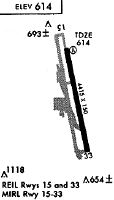
| A81-APT | ACTVT PAPI RWY 15; REIL RWY 15 & 33; MIRL RWY 15/33 - CTAF. |
| A81-BCN | DUSK-DAWN |
Runways
Runway Summary
| Runways: | 15/33 |
| Longest Runway: | 15/33 is 4423 ft (1348 m) long |
| Runways with an Instrument Approach: | 15 |
UKI Airport Runway Details
| Runway 15/33 | 4423 ft x 150 ft (1348 m x 46 m) | |
| Runway Length Source: | 3RD PARTY SURVEY as of 11/23/1997 | |
| Surface: | Asphalt - Excellent condition - No special surface treatment | |
| Runway Edge Lights: | Medium Intensity | |
Runway Weight Bearing Capacity (in thousands of pounds) |
||
| Single Wheel Landing Gear: | 28.0 | |
Runway 15 |
Runway 33 |
|
Elevation: |
616.8 | 604.7 |
Latitude: |
39-07-54.8340N | 39-07-12.0246N |
Longitude: |
123-12-08.7700W | 123-11-57.4192W |
|
Runway True Alignment: |
168 | 348 |
ILS Type: |
LOC/DME | |
Glide Path Angle: |
3.0 degrees | 0.0 degrees |
Traffic Pattern: |
Left | Right |
Runway Markings Type: |
Nonprecision Instrument | Basic |
Runway Markings Condition: |
Good | Good |
Object at End: |
TREES | TREES |
Object Height: |
27 | 27 |
Distance from End: |
950 | 700 |
Object Centerline Offset: |
190 ft. right of centerline | 135 ft. left of centerline |
Visual Glide Slope Indicators: |
4-Light PAPI On Left Side Of Runway | |
REIL: |
Yes | Yes |
Touchdown Lights: |
No | No |
Centerline Lights: |
No | No |
Threshold Crossing Height: |
29 |
Services
Airframe Repair: |
Major |
Powerplant Repair: |
Major |
Bottled Oxygen: |
High Pressure / Low Pressure |
Fuel Available: |
100LL |
Landing Fees: |
No |
Parking: |
Tiedowns available |
Maps & Diagrams
UKI Sectional
Flight Planning
at skyvector.com
at skyvector.com