Location
Latitude: |
39-56-32.1910N (39.942275) |
Longitude: |
091-11-32.6560W (-91.192404) |
Elevation: |
768.7 feet MSL (234 m MSL) |
Magnetic Variation: |
1.3 W (as of April 2024 from WMM2020 model) |
Time Zone: |
UTC -6.0 (Standard Time) UTC -5.0 (Daylight Savings Time) |
From City: |
10 N.M. E of Quincy, Illinois |
Found On: |
Kansas City Chart |
FAA Region: |
AGL |
Contacts
Manager: |
Publicly owned: |
| CHUCK MILLER 1645 HWY 104 QUINCY, IL 62305 217-885-3285 |
CITY OF QUINCY 1645 HWY 104 QUINCY, IL 62305 217-885-3285 |
Operations
Airport Status: |
Operational |
Facility Use: |
Public |
Type: |
Airport |
Activation Date: |
04/1947 |
Control tower: |
No |
Attendance (Months/Days/Hours): |
Months/Days/Hours ALL/MON-FRI/0600-2000 |
Boundary ARTCC: |
ZKC (Kansas City) |
Responsible ARTCC: |
ZKC (Kansas City) |
Lighting Schedule: |
SEE RMK |
Segmented Circle Indicator: |
Yes |
Traffic Pattern Altitude (MSL): |
1769 feet (539 m) |
NOTAMs Facility: |
UIN |
NOTAM-D Service: |
Yes |
International Airport of Entry: |
No |
Customs Landing Rights: |
No |
Military Landing Rights: |
Yes |
Civil/Military Joint Use: |
No |
Aircraft Rescue and Firefighting: |
Class IV ARFF Index: A Air Carrier Service: Not Scheduled Certification Date: 05/1973 |
Based Aircraft
| Single Engine: | 29 |
| Multi Engine: | 7 |
| Jet Engine: | 14 |
| Ultralights: | 1 |
Annual Operations (as of 01/01/2021)
| Total Operations: | 19444 | |
| Air Taxi: | 3808 | 19.6% |
| GA Local: | 13560 | 69.7% |
| GA Itinerant: | 2050 | 10.5% |
| Military Aircraft: | 26 | 0.1% |
Communications
| CTAF: | 123.000 |
| Unicom: | 123.000 |
| ASOS: | 121.425 (217-885-3319) |
- APCH/DEP SVC PRVDD BY KANSAS CITY ARTCC ON FREQS 126.225/317.775 (QUINCY RCAG).
Fixed Based Operators (FBOs) & Fuel
(Click on a business for detail)
Please help us keep this information up to date. This is a FREE SERVICE just like everything else on Airport Guide! If you see that a business needs to be added, modified, or deleted please fill out our Update Form.
To add, modify, or delete a business click here.
Please help us keep this information up to date. This is a FREE SERVICE just like everything else on Airport Guide! If you see that a business needs to be added, modified, or deleted please fill out our Update Form.
Area Code: 217 |
| Business Name | Frequency | Phone | Fuel Grade |
|---|---|---|---|
| Curtis Aviation Services
Website Update FBO info |
885-3353 | 100LL, Jet A | |

|
Air Bp | 100LL - 2.51 USD per gallon on 10/13/01 |
Trucks Volume discounts available. |
|
|
Air Bp | Jet A - 2.13 USD per gallon on 10/13/01 |
Trucks Volume discounts available. |
| Heetco Jet Center
Website Update FBO info |
Unicom 123.0 | 754-3197 |
Flight Service Stations
| Primary | Alternate | |
| FSS on Field: | N | |
| FSS Name (ID): | Saint Louis(STL) | |
| Frequency: | ||
| Toll Free Phone: | 1-800-WX-BRIEF |
Instrument Procedures / Charts
FAA Terminal Procedures valid from 0901Z 03/21/24 to 0901Z 04/18/24.
There are various types of charts available for an airport. They are listed in the Page Type column. Here is a legend for those types:
APD - Airport Diagram
DP - Departure Procedure Charts
HOT - Hot Spots
IAP - Instrument Approach Procedure Charts
MIN - Minimums
STAR - Standard Terminal Arrival Charts
| Page Type | Page Name | Volume | Action Since Last Cycle |
|---|---|---|---|
| APD | AIRPORT DIAGRAM | EC-3 | |
| HOT | HOT SPOT | EC-3 | |
| IAP | ILS OR LOC RWY 04 | EC-3 | |
| IAP | LOC BC RWY 22 | EC-3 | |
| IAP | NDB RWY 04 | EC-3 | |
| IAP | RNAV (GPS) RWY 04 | EC-3 | |
| IAP | RNAV (GPS) RWY 13 | EC-3 | |
| IAP | RNAV (GPS) RWY 22 | EC-3 | |
| IAP | RNAV (GPS) RWY 31 | EC-3 | |
| MIN | ALTERNATE MINIMUMS | EC-3 | |
| MIN | TAKEOFF MINIMUMS | EC-3 |
Terminal Procedures are only available for airports in several countries with more being added all the time. If you are looking for a specific country's charts, please send an email to support(at)airportguide.com stating the country name. This will be used to prioritize the implementation.
Navigation Aids (Navaids) near UIN
| Dist (NM) | ID | Morse Code | Name | Type | Freq | True Hdg | Mag Hdg |
|---|---|---|---|---|---|---|---|
| 4.4 | UI | . . _ . . | Quincy | NDB | 293 | 220 | 221 |
| 6.9 | UIN | . . _ . . _ . | Quincy | TACAN | 113.60 | 215 | 216 |
| 33.2 | EOK | . _ _ _ _ . _ | Keokuk | NDB | 366 | 340 | 341 |
| 42.8 | BR | _ . . . . _ . | Burns | NDB | 390 | 4 | 5 |
| 45.0 | IJX | . . . _ _ _ _ . . _ | Jacksonville | DME | 108.6 | 102 | 104 |
| 45.1 | JZY | . _ _ _ _ _ . . _ . _ _ | Macomb | NDB | 251 | 39 | 41 |
| 48.4 | BRL | _ . . . . _ . . _ . . | Burlington | VOR-DME | 111.40 | 14 | 15 |
| 61.9 | MCM | _ _ _ . _ . _ _ | Macon | DME | 112.9 | 254 | 255 |
| 62.2 | MPZ | _ _ . _ _ . _ _ . . | Mount Pleasant | NDB | 212 | 346 | 347 |
| 63.3 | CTK | _ . _ . _ _ . _ | Canton | NDB | 236 | 53 | 55 |
| 65.3 | IRK | . . . _ . _ . _ | Kirksville | VORTAC | 114.60 | 280 | 281 |
| 65.9 | HLV | . . . . . _ . . . . . _ | Hallsville | VORTAC | 114.20 | 221 | 222 |
| 66.8 | SP | . . . . _ _ . | Huskk | NDB | 382 | 98 | 100 |
| 69.0 | GBG | _ _ . _ . . . _ _ . | Galesburg | DME | 109.8 | 29 | 31 |
| 70.0 | SPI | . . . . _ _ . . . | Spinner | VORTAC | 112.70 | 94 | 96 |
| 72.8 | STL | . . . _ . _ . . | St Louis | VORTAC | 117.40 | 152 | 154 |
| 73.1 | LQ | . _ . . _ _ . _ | Licol | NDB | 375 | 90 | 92 |
| 73.7 | FFL | . . _ . . . _ . . _ . . | Fairfield | NDB | 332 | 330 | 331 |
| 74.2 | CJ | _ . _ . . _ _ _ | Calde | NDB | 240 | 96 | 98 |
| 74.3 | BEX | _ . . . . _ . . _ | Bloomfield | NDB | 269 | 310 | 311 |
Nearby Airports with Fuel
Notices to Airmen (NOTAMS)
Remarks
| A110-1 | MIGRATORY WATERFOWL ON & INVOF ARPT. |
| A110-2 | FICON ARE NOT MONTRD BTWN THE HRS OF 2100-0600. |
| A110-3 | ARPT WDI OTS INDEFLY. |
| A110-4 | USE CTN; NO LINE OF SIGHT BTWN RWY ENDS DUE TO TOPOGRAPHY AND BLDG OBSTNS; ALL DEP/ARR ACFT USE CTAF 123.0. |
| A110-7 | FOR CD IF UNA TO CTC ON FSS FREQ, CTC KANSAS CITY ARTCC AT 913-254-8508. |
| A110-8 | ARFF NOT AVBL 24 HRS. 24 HRS PPR FOR UNSKED ACFT OPS; CTC ARPT MGR 217-885-3285 OR 217-885-3262. |
| A110-9 | RWY 04 IS THE PREFERRED RWY IN CALM WIND CONDITIONS. |
| A13 | EXT: 8. |
| A14 | EMAIL ADDRESS: QUINCYAIRPORT@QUINCYIL.GOV |
| A17 | FOR FUEL ATTENDANT OTR HRS CALL 217-885-3353 OR 217-779-5091. ACFT MAINT TO COORD CALL 217-885-3353. |
| A43-13 | PAPI UNUSBL BYD 9 DEGS RIGHT OF CNTRLN. |
| A81-APT | ACTVT MALSR RWY 04; REIL RWY 22; PAPI RWY 13, 31, 04 & 22; HIRL RWY 04/22; MIRL RWY 13/31 - CTAF. HIRL RWY 04/22 PRESET LOW INTST; TO INCR INTST - CTAF. |
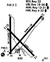
Runways
Runway Summary
| Runways: | 04/22 13/31 |
| Longest Runway: | 04/22 is 7098 ft (2163 m) long |
| Runways with an Instrument Approach: | 04 |
UIN Airport Runway Details
| Runway 04/22 | 7098 ft x 150 ft (2163 m x 46 m) | |
| Runway Length Source: | 3RD PARTY SURVEY as of 01/09/2008 | |
| Surface: | Asphalt - Fair condition - Saw-cut or plastic grooved | |
| Runway Pavement Class: | 71 /R/C/X/T | |
| Runway Edge Lights: | High Intensity | |
Runway Weight Bearing Capacity (in thousands of pounds) |
||
| Single Wheel Landing Gear: | 120.0 | |
| Dual Wheel Landing Gear: | 231.0 | |
| Dual Tandem Wheel Landing Gear: | 373.0 | |
Runway 04 |
Runway 22 |
|
Elevation: |
755.7 | 746.4 |
Latitude: |
39-56-10.1210N | 39-57-03.6087N |
Longitude: |
091-11-58.4277W | 091-10-59.4686W |
|
Runway True Alignment: |
040 | 220 |
ILS Type: |
ILS | |
Glide Path Angle: |
3.0 degrees | 3.0 degrees |
Traffic Pattern: |
Left | Left |
Runway Markings Type: |
Precision Instrument | Precision Instrument |
Runway Markings Condition: |
Good | Good |
Object at End: |
ROAD | |
Object Height: |
16 | |
Distance from End: |
848 | |
Object Centerline Offset: |
586 ft. right of centerline | |
Visual Glide Slope Indicators: |
4-Light PAPI On Right Side Of Runway | 4-Light PAPI On Left Side Of Runway |
Approach Light System: |
1,400 Foot Medium Intensity Approach Lighting System With Runway Alignment Indicator Lights | |
REIL: |
Yes | |
Touchdown Lights: |
No | No |
Centerline Lights: |
No | No |
Threshold Crossing Height: |
42 | 46 |
Declared Distances |
||
Take Off Run Avbl. (TORA): |
7098 | 7098 |
Take Off Distance Avbl. (TODA): |
7098 | 7098 |
Actual Stop Dist. Avbl. (ASDA): |
7098 | 7098 |
Landing Dist. Avbl. (LDA): |
7098 | 7098 |
| Runway 13/31 | 5397 ft x 150 ft (1645 m x 46 m) | |
| Runway Length Source: | 3RD PARTY SURVEY as of 10/29/2007 | |
| Surface: | Asphalt - Fair condition - Saw-cut or plastic grooved | |
| Runway Pavement Class: | 71 /R/C/X/T | |
| Runway Edge Lights: | Medium Intensity | |
Runway Weight Bearing Capacity (in thousands of pounds) |
||
| Single Wheel Landing Gear: | 120.0 | |
| Dual Wheel Landing Gear: | 231.0 | |
| Dual Tandem Wheel Landing Gear: | 373.0 | |
Runway 13 |
Runway 31 |
|
Elevation: |
765.3 | 768.7 |
Latitude: |
39-56-45.0014N | 39-56-07.0806N |
Longitude: |
091-12-01.8892W | 091-11-13.1715W |
|
Runway True Alignment: |
135 | 315 |
Glide Path Angle: |
3.0 degrees | 3.0 degrees |
Traffic Pattern: |
Left | Left |
Runway Markings Type: |
Nonprecision Instrument | Nonprecision Instrument |
Runway Markings Condition: |
Good | Good |
Object at End: |
ROAD | POLE |
Object Height: |
11 | 15 |
Distance from End: |
525 | 800 |
Object Centerline Offset: |
586 ft. right of centerline | |
Visual Glide Slope Indicators: |
4-Light PAPI On Left Side Of Runway | 4-Light PAPI On Right Side Of Runway |
REIL: |
No | No |
Touchdown Lights: |
No | No |
Centerline Lights: |
No | No |
Threshold Crossing Height: |
33 | 40 |
Declared Distances |
||
Take Off Run Avbl. (TORA): |
5397 | 5397 |
Take Off Distance Avbl. (TODA): |
5397 | 5397 |
Actual Stop Dist. Avbl. (ASDA): |
5123 | 5146 |
Landing Dist. Avbl. (LDA): |
5123 | 5146 |
Services
Airframe Repair: |
Major |
Powerplant Repair: |
Major |
Bottled Oxygen: |
None |
Bulk Oxygen: |
Low Pressure |
Fuel Available: |
100LL, Jet A |
Landing Fees: |
No |
Parking: |
Hangars available |
Maps & Diagrams
UIN Sectional
Flight Planning
at skyvector.com
at skyvector.com