Location
Latitude: |
43-38-33.8100N (43.642725) |
Longitude: |
111-55-44.9850W (-111.929163) |
Elevation: |
4845.0 feet MSL (1477 m MSL) |
Magnetic Variation: |
11.4 E (as of April 2024 from WMM2020 model) |
Time Zone: |
UTC -7.0 (Standard Time) UTC -6.0 (Daylight Savings Time) |
From City: |
02 N.M. S of Rigby, Idaho |
Found On: |
Salt Lake City Chart |
FAA Region: |
ANM |
Contacts
Manager: |
Publicly owned: |
| BRUCE SPAULDING 230 N 4045 E RIGBY, ID 83442 (208) 716-3584 |
CITY OF RIGBY P.O. BOX 275 RIGBY, ID 83442 208-745-8111 |
Operations
Airport Status: |
Operational |
Facility Use: |
Public |
Type: |
Airport |
Activation Date: |
01/1949 |
Control tower: |
No |
Attendance (Months/Days/Hours): |
Months/Days/Hours Unattended |
Boundary ARTCC: |
ZLC (Salt Lake City) |
Responsible ARTCC: |
ZLC (Salt Lake City) |
Lighting Schedule: |
SEE RMK |
Segmented Circle Indicator: |
Yes |
Traffic Pattern Altitude (MSL): |
5845 feet (1782 m) |
NOTAMs Facility: |
BOI |
NOTAM-D Service: |
Yes |
International Airport of Entry: |
No |
Customs Landing Rights: |
No |
Military Landing Rights: |
No |
Civil/Military Joint Use: |
No |
Based Aircraft
| Single Engine: | 22 |
| Multi Engine: | 2 |
| Ultralights: | 4 |
Annual Operations (as of 07/30/2021)
| Total Operations: | 10800 | |
| GA Local: | 7800 | 72.2% |
| GA Itinerant: | 3000 | 27.8% |
Communications
| CTAF: | 122.900 |
Fixed Based Operators (FBOs) & Fuel
(Click on a business for detail)
Please help us keep this information up to date. This is a FREE SERVICE just like everything else on Airport Guide! If you see that a business needs to be added, modified, or deleted please fill out our Update Form.
To add, modify, or delete a business click here.
Please help us keep this information up to date. This is a FREE SERVICE just like everything else on Airport Guide! If you see that a business needs to be added, modified, or deleted please fill out our Update Form.
Area Code: 208 |
| Business Name | Frequency | Phone | Fuel Grade |
|---|---|---|---|
| Queen Bee Air Specialities, Inc.
Update FBO info |
Unicom 122.8 | 745-7654 |
Flight Service Stations
| Primary | Alternate | |
| FSS on Field: | N | |
| FSS Name (ID): | Boise(BOI) | |
| Frequency: | ||
| Toll Free Phone: | 1-800-WX-BRIEF |
Instrument Procedures / Charts
Terminal Procedures are only available for airports in several countries with more being added all the time. If you are looking for a specific country's charts, please send an email to support(at)airportguide.com stating the country name. This will be used to prioritize the implementation.
Navigation Aids (Navaids) near U56
| Dist (NM) | ID | Morse Code | Name | Type | Freq | True Hdg | Mag Hdg |
|---|---|---|---|---|---|---|---|
| 3.5 | ID | . . _ . . | Uconn | NDB | 324 | 219 | 208 |
| 9.5 | IDA | . . _ . . . _ | Idaho Falls | VOR-DME | 113.85 | 218 | 207 |
| 16.2 | SWU | . . . . _ _ . . _ | Sweden | NDB | 350 | 218 | 207 |
| 29.4 | DBS | _ . . _ . . . . . . | Dubois | VORTAC | 116.90 | 335 | 324 |
| 48.1 | PI | . _ _ . . . | Tyhee | NDB | 383 | 212 | 201 |
| 52.0 | JAC | . _ _ _ . _ _ . _ . | Jackson | VOR-DME | 115.40 | 91 | 80 |
| 56.1 | PIH | . _ _ . . . . . . . | Pocatello | VOR-DME | 112.60 | 214 | 203 |
| 64.2 | LO | . _ . . _ _ _ | Targy | NDB | 415 | 29 | 18 |
| 70.0 | DNW | _ . . _ . . _ _ | Dunoir | VOR-DME | 117.20 | 80 | 69 |
| 70.9 | WYS | . _ _ _ . _ _ . . . | West Yellowstone | DME | 114.85 | 28 | 17 |
| 71.8 | ESY | . . . . _ . _ _ | Yellowstone | NDB | 338 | 28 | 17 |
| 89.6 | MLD | _ _ . _ . . _ . . | Malad City | VOR-DME | 117.40 | 195 | 184 |
| 98.2 | EKS | . _ . _ . . . | Ennis | NDB | 286 | 6 | 355 |
| 99.9 | DLN | _ . . . _ . . _ . | Dillon | VOR-DME | 113.00 | 344 | 332 |
Nearby Airports with Fuel
Notices to Airmen (NOTAMS)
Remarks
| A110-1 | (E81) ONLY TWY EXITS LGTD. |
| A110-2 | NOISE ABATEMENT PROCEDURES IN EFFECT. CALL AMGR 208-716-3584 |
| A110-3 | FOR CD CTC SALT LAKE ARTCC AT 801-320-2568. |
| A57-19 | APCH SLOPE 29:1 TO DSPLCD THR. |
| A58-01 | RY 01 +5 FT FENCE AT 190 FT, ON CNTRLN. |
| A81-APT | ACTVT MIRL RWY 01/19 - CTAF 122.9. |
| E111 | ESTABD PRIOR TO 15 MAY 1959. |
Runways
Runway Summary
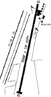
| Runways: | 01/19 |
| Longest Runway: | 01/19 is 3727 ft (1136 m) long |
| Runways with an Instrument Approach: |
U56 Airport Runway Details
| Runway 01/19 | 3727 ft x 50 ft (1136 m x 15 m) | |
| Runway Length Source: | STATE as of 05/13/2015 | |
| Surface: | Asphalt - Good condition - No special surface treatment | |
| Runway Edge Lights: | Medium Intensity | |
Runway 01 |
Runway 19 |
|
Latitude: |
43-38-16.6000N | 43-38-51.0200N |
Longitude: |
111-55-54.0000W | 111-55-35.9700W |
Glide Path Angle: |
0.0 degrees | 0.0 degrees |
Traffic Pattern: |
Left | Left |
Runway Markings Type: |
Basic | Basic |
Runway Markings Condition: |
Fair | Fair |
Object at End: |
FENCE | ROAD |
Object Height: |
5 | 17 |
Distance from End: |
200 | 275 |
Object Centerline Offset: |
0 ft. left and right of centerline | 0 ft. left and right of centerline |
Displaced Threshold: |
225 | |
Threshold Latitude: |
43-38-48.9200N | |
Threshold Longitude: |
111-55-37.0500W |
Services
Airframe Repair: |
Minor |
Powerplant Repair: |
Minor |
Fuel Available: |
100LL, Jet A-1, Jet A-1+ |
Landing Fees: |
No |
Parking: |
Hangars and tiedowns available |
Maps & Diagrams
U56 Sectional
Flight Planning
at skyvector.com
at skyvector.com