Location
Latitude: |
42-28-54.5130N (42.481809) |
Longitude: |
114-29-15.8500W (-114.487736) |
Elevation: |
4153.4 feet MSL (1266 m MSL) |
Magnetic Variation: |
12.1 E (as of April 2024 from WMM2020 model) |
Time Zone: |
UTC -7.0 (Standard Time) UTC -6.0 (Daylight Savings Time) |
From City: |
04 N.M. S of Twin Falls, Idaho |
Found On: |
Salt Lake City Chart |
FAA Region: |
ANM |
Contacts
Manager: |
Publicly owned: |
| BILL CARBERRY P.O. BOX 1907 TWIN FALLS, ID 83303 208-733-5215 |
CITY & COUNTY OF TWIN FALLS P.O. BOX 1907 TWIN FALLS, ID 83303 208-733-5215 |
Operations
Airport Status: |
Operational |
Facility Use: |
Public |
Type: |
Airport |
Activation Date: |
02/1948 |
Control tower: |
Yes |
Attendance (Months/Days/Hours): |
Months/Days/Hours ALL/ALL/0630-2000 |
Boundary ARTCC: |
ZLC (Salt Lake City) |
Responsible ARTCC: |
ZLC (Salt Lake City) |
Lighting Schedule: |
SEE RMK |
Segmented Circle Indicator: |
Yes |
Traffic Pattern Altitude (MSL): |
5153 feet (1571 m) |
NOTAMs Facility: |
TWF |
NOTAM-D Service: |
Yes |
International Airport of Entry: |
No |
Customs Landing Rights: |
No |
Military Landing Rights: |
Yes |
Civil/Military Joint Use: |
No |
Aircraft Rescue and Firefighting: |
Class I ARFF Index: A Air Carrier Service: Scheduled Certification Date: 05/1973 |
Based Aircraft
| Single Engine: | 84 |
| Multi Engine: | 18 |
| Jet Engine: | 1 |
| GA Helicopters: | 8 |
Annual Operations (as of 01/01/2020)
| Total Operations: | 34611 | |
| Commercial: | 414 | 1.2% |
| Air Taxi: | 5000 | 14.4% |
| GA Local: | 14793 | 42.7% |
| GA Itinerant: | 13338 | 38.5% |
| Military Aircraft: | 1066 | 3.1% |
Communications
| CTAF: | 118.200 |
| Unicom: | 122.950 |
| Tower: | TWIN FALLS 118.2 317.5 Hrs: 0600-2100 |
| Clearance Del.: | 123.65 |
| Ground: | 121.7 |
| Approach: | TWIN FALLS 126.7 353.75 Hrs: 0600-2100 SALT LAKE ARTCC Hrs: 2100-0600 |
| Departure: | TWIN FALLS 126.7 353.75 Hrs: 0600-2100 SALT LAKE ARTCC Hrs: 2100-0600 |
| ASOS: | 135.025 (208-733-1878) |
- APCH/DEP CTL SVC PRVDD BY SALT LAKE ARTCC (ZLC) ON FREQS 118.05/363.0 (BURLEY RCAG) WHEN TWIN FALLS APCH CTL (TWF) CLSD.
Fixed Based Operators (FBOs) & Fuel
(Click on a business for detail)
Please help us keep this information up to date. This is a FREE SERVICE just like everything else on Airport Guide! If you see that a business needs to be added, modified, or deleted please fill out our Update Form.
To add, modify, or delete a business click here.
Please help us keep this information up to date. This is a FREE SERVICE just like everything else on Airport Guide! If you see that a business needs to be added, modified, or deleted please fill out our Update Form.
Area Code: 208 |
| Business Name | Frequency | Phone | Fuel Grade |
|---|---|---|---|
| Avcenter
Update FBO info |
Unicom 122.95 | 736-4504 | |
| Lewis Aviation
Update FBO info |
733-4755 | ||
| Northwest Warbirds
Update FBO info |
734-1941 | ||
| Reeder Flying Service
Update FBO info |
Unicom 122.95 | 733-5920 | 100LL, Jet A |
| Snake River Aircraft Maintenance
Update FBO info |
733-7864 |
Flight Service Stations
| Primary | Alternate | |
| FSS on Field: | N | |
| FSS Name (ID): | Boise(BOI) | |
| Frequency: | ||
| Toll Free Phone: | 1-800-WX-BRIEF |
Instrument Procedures / Charts
FAA Terminal Procedures valid from 0901Z 03/21/24 to 0901Z 04/18/24.
There are various types of charts available for an airport. They are listed in the Page Type column. Here is a legend for those types:
APD - Airport Diagram
DP - Departure Procedure Charts
HOT - Hot Spots
IAP - Instrument Approach Procedure Charts
MIN - Minimums
STAR - Standard Terminal Arrival Charts
| Page Type | Page Name | Volume | Action Since Last Cycle |
|---|---|---|---|
| APD | AIRPORT DIAGRAM | NW-1 | |
| DP | SNAKO THREE | NW-1 | |
| HOT | HOT SPOT | NW-1 | |
| IAP | ILS OR LOC RWY 26 | NW-1 | |
| IAP | RNAV (GPS) RWY 08 | NW-1 | |
| IAP | RNAV (GPS) RWY 26 | NW-1 | |
| IAP | VOR RWY 08 | NW-1 | |
| IAP | VOR RWY 26 | NW-1 | |
| IAP | VOR/DME RWY 08 | NW-1 | |
| LAH | LAHSO | NW-1 | |
| MIN | ALTERNATE MINIMUMS | NW-1 | |
| MIN | TAKEOFF MINIMUMS | NW-1 |
Terminal Procedures are only available for airports in several countries with more being added all the time. If you are looking for a specific country's charts, please send an email to support(at)airportguide.com stating the country name. This will be used to prioritize the implementation.
Navigation Aids (Navaids) near TWF
| Dist (NM) | ID | Morse Code | Name | Type | Freq | True Hdg | Mag Hdg |
|---|---|---|---|---|---|---|---|
| 0.1 | TWF | _ . _ _ . . _ . | Twin Falls | VORTAC | 113.10 | 214 | 202 |
| 5.9 | TW | _ . _ _ | Strik | NDB | 389 | 91 | 79 |
| 27.3 | HDG | . . . . _ . . _ _ . | Steelhead | NDB | 211 | 342 | 330 |
| 28.1 | BYI | _ . . . _ . _ _ . . | Burley | VOR-DME | 114.10 | 77 | 65 |
| 52.0 | HLE | . . . . . _ . . . | Hailey | NDB-DME | 220 | 11 | 359 |
| 64.0 | STI | . . . _ . . | Sturgeon | NDB | 333 | 306 | 294 |
| 64.2 | LIA | . _ . . . . . _ | Liberator | VOR | 114.90 | 298 | 286 |
| 69.7 | MUO | _ _ . . _ _ _ _ | Mountain Home | TACAN | 114.00 | 299 | 287 |
| 73.1 | LCU | . _ . . _ . _ . . . _ | Lucin | VORTAC | 113.60 | 156 | 144 |
| 83.2 | LWL | . _ . . . _ _ . _ . . | Wells | VOR-DME | 114.65 | 195 | 183 |
| 84.3 | PIH | . _ _ . . . . . . . | Pocatello | VOR-DME | 112.60 | 73 | 61 |
| 91.6 | PI | . _ _ . . . | Tyhee | NDB | 383 | 70 | 58 |
| 91.9 | MLD | _ _ . _ . . _ . . | Malad City | VOR-DME | 117.40 | 99 | 87 |
| 98.6 | BOI | _ . . . _ _ _ . . | Boise | VORTAC | 113.30 | 311 | 299 |
| 99.6 | BOI | _ . . . _ _ _ . . | Boise | VOT | 116.70 | 310 | 298 |
Nearby Airports with Fuel
| Dist (NM) | Name (Airport IDs) | True Hdg | Mag Hdg | Fuel Grade |
|---|---|---|---|---|
| 14.8 | Jerome County Airport (KJER JER) |
5 | 353 | 100LL, Jet A, Jet A+ |
| 15.5 | Buhl Municipal Airport (U03) |
296 | 284 | 100LL, MOGAS |
| 28.9 | Gooding Municipal Airport (GNG KGNG GNG) |
334 | 322 | 100LL, Jet A |
| 31.3 | Jackpot/Hayden Field Airport (KPT 06U) |
194 | 182 | 100LL |
| 31.9 | Burley Municipal Airport (BYI KBYI BYI) |
83 | 71 | 100LL, Jet A |
| 61.9 | Friedman Meml Airport (SUN KSUN SUN) |
7 | 355 | 100LL, Jet A-1+ |
| 75.8 | American Falls Airport (U01) |
74 | 62 | 100LL |
| 84.2 | Wells Municipal/Harriet Field Airport (LWL KLWL LWL) |
193 | 181 | 100LL, Jet A |
| 84.2 | Arco-Butte County Airport (KAOC AOC) |
36 | 24 | 100LL |
| 87.3 | Pocatello Regional Airport (PIH KPIH PIH) |
72 | 61 | 100LL, Jet A-1, Jet A-1+ |
| 99.1 | Malad City Airport (MLD KMLD MLD) |
100 | 89 | 100LL |
Notices to Airmen (NOTAMS)
Remarks
| A110-1 | RY 12/30 & TWYS G H J & K NON-ACR MOVEMENT AREA. |
| A110-2 | NO LINE OF SIGHT BETWEEN APCH END OF RY 26 AND APCH END OF RY 12. |
| A110-3 | FOR CD IF UNA TO CTC ON FSS FREQ, CTC SALT LAKE ARTCC AT 801-320-2568. |
| A24 | LANDING FEE FOR ALL FAR PART 121, 135 OPERATORS AND GENERAL AVIATION PART 91 AIRCRAFT GREATER THAN 12,500 LBS MGLW. |
| A26 | PPR FOR UNSKED ACR OPNS WITH MORE THAN 30 PSGR SEATS CALL AMGR 208-733-5215. |
| A70-FUEL-10 | 0LL ADDNL FUEL SVC FEE BTN 2000-0630; CALL 208-733-5920 OR 539-4034 FOR INFO. |
| A81-APT | WHEN ATCT CLSD ACTVT HIRL RY 08/26, MALSR RY 26 & REIL RY 08 - CTAF. |
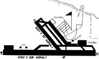
Runways
Runway Summary
| Runways: | 08/26 12/30 |
| Longest Runway: | 08/26 is 8704 ft (2653 m) long |
| Runways with an Instrument Approach: | 26 |
TWF Airport Runway Details
| Runway 08/26 | 8704 ft x 150 ft (2653 m x 46 m) | |
| Runway Length Source: | 3RD PARTY SURVEY as of 04/06/2021 | |
| Surface: | Asphalt - Good condition - Porous friction course | |
| Runway Pavement Class: | 46 /F/D/W/T | |
| Runway Edge Lights: | High Intensity | |
Runway Weight Bearing Capacity (in thousands of pounds) |
||
| Single Wheel Landing Gear: | 75.0 | |
| Dual Wheel Landing Gear: | 200.0 | |
| Dual Tandem Wheel Landing Gear: | 250.0 | |
Runway 08 |
Runway 26 |
|
Elevation: |
4143.7 | 4151.5 |
Latitude: |
42-28-52.5443N | 42-28-50.5753N |
Longitude: |
114-30-11.6004W | 114-28-15.5042W |
|
Runway True Alignment: |
091 | 271 |
ILS Type: |
ILS | |
Glide Path Angle: |
3.0 degrees | 3.0 degrees |
Traffic Pattern: |
Left | Left |
Runway Markings Type: |
Nonprecision Instrument | Precision Instrument |
Runway Markings Condition: |
Good | Good |
Visual Glide Slope Indicators: |
4-Box VASI On Left Side Of Runway | 4-Light PAPI On Left Side Of Runway |
Approach Light System: |
1,400 Foot Medium Intensity Approach Lighting System With Runway Alignment Indicator Lights | |
REIL: |
Yes | No |
Threshold Crossing Height: |
49 | 55 |
| Runway 12/30 | 3224 ft x 75 ft (983 m x 23 m) | |
| Runway Length Source: | 3RD PARTY SURVEY as of 04/06/2021 | |
| Surface: | Asphalt - Good condition - No special surface treatment | |
| Runway Pavement Class: | 8 /F/D/Z/T | |
Runway Weight Bearing Capacity (in thousands of pounds) |
||
| Single Wheel Landing Gear: | 19.0 | |
Runway 12 |
Runway 30 |
|
Elevation: |
4106.7 | 4147.5 |
Latitude: |
42-29-13.9822N | 42-28-50.9648N |
Longitude: |
114-29-36.9185W | 114-29-07.1937W |
|
Runway True Alignment: |
136 | 316 |
Glide Path Angle: |
0.0 degrees | 0.0 degrees |
Traffic Pattern: |
Left | Left |
Runway Markings Type: |
Basic | Basic |
Runway Markings Condition: |
Good | Good |
Object at End: |
TREES | |
Object Height: |
75 | |
Distance from End: |
2000 | |
REIL: |
No | No |
Services
Airframe Repair: |
None |
Powerplant Repair: |
None |
Bottled Oxygen: |
None |
Bulk Oxygen: |
None |
Fuel Available: |
100LL |
Landing Fees: |
No |
Parking: |
Tiedowns available |
Maps & Diagrams
TWF Sectional
Flight Planning
at skyvector.com
at skyvector.com