Location
Latitude: |
38-03-35.6170N (38.059894) |
Longitude: |
117-05-11.7630W (-117.086601) |
Elevation: |
5430.3 feet MSL (1655 m MSL) |
Magnetic Variation: |
12 E (as of April 2024 from WMM2020 model) |
Time Zone: |
UTC -8.0 (Standard Time) UTC -7.0 (Daylight Savings Time) |
From City: |
07 N.M. E of Tonopah, Nevada |
Found On: |
Las Vegas Chart |
FAA Region: |
AWP |
Contacts
Manager: |
Publicly owned: |
| THOMAS BOLLING 2041 E. CALVADA BLVD. N. SUITE #3, 250 N. HWY 160 #2 PAHRUMP, NV 89048 775-751-6270 |
NYE COUNTY P O BOX 1031 TONOPAH, NV 89049 (775) 209-4174 |
Operations
Airport Status: |
Operational |
Facility Use: |
Public |
Type: |
Airport |
Activation Date: |
09/1944 |
Control tower: |
No |
Attendance (Months/Days/Hours): |
Months/Days/Hours ALL/ALL/0600-2300 |
Boundary ARTCC: |
ZLA (Los Angeles) |
Responsible ARTCC: |
ZLA (Los Angeles) |
Lighting Schedule: |
SEE RMK |
Segmented Circle Indicator: |
Yes |
Traffic Pattern Altitude (MSL): |
6430 feet (1960 m) |
NOTAMs Facility: |
TPH |
NOTAM-D Service: |
Yes |
International Airport of Entry: |
No |
Customs Landing Rights: |
No |
Military Landing Rights: |
Yes |
Civil/Military Joint Use: |
No |
Based Aircraft
| Single Engine: | 5 |
| Multi Engine: | 1 |
| GA Helicopters: | 1 |
Annual Operations (as of 05/18/2022)
| Total Operations: | 7002 | |
| Air Taxi: | 1825 | 26.1% |
| GA Local: | 1027 | 14.7% |
| GA Itinerant: | 3710 | 53.0% |
| Military Aircraft: | 440 | 6.3% |
Communications
| CTAF: | 123.000 |
| Unicom: | 123.000 |
| ASOS: | 118.875 (775-482-3441) |
Fixed Based Operators (FBOs) & Fuel
(Click on a business for detail)
Please help us keep this information up to date. This is a FREE SERVICE just like everything else on Airport Guide! If you see that a business needs to be added, modified, or deleted please fill out our Update Form.
To add, modify, or delete a business click here.
Please help us keep this information up to date. This is a FREE SERVICE just like everything else on Airport Guide! If you see that a business needs to be added, modified, or deleted please fill out our Update Form.
Area Code: 775 |
| Business Name | Frequency | Phone | Fuel Grade |
|---|---|---|---|
| Desert Flying Service
Update FBO info |
Unicom 123.0 | 482-3626 | 100LL, Jet A |
Flight Service Stations
| Primary | Alternate | |
| FSS on Field: | ||
| FSS Name (ID): | Reno(RNO) | |
| Frequency: | ||
| Toll Free Phone: | 1-800-WX-BRIEF |
Instrument Procedures / Charts
FAA Terminal Procedures valid from 0901Z 03/21/24 to 0901Z 04/18/24.
There are various types of charts available for an airport. They are listed in the Page Type column. Here is a legend for those types:
APD - Airport Diagram
DP - Departure Procedure Charts
HOT - Hot Spots
IAP - Instrument Approach Procedure Charts
MIN - Minimums
STAR - Standard Terminal Arrival Charts
| Page Type | Page Name | Volume | Action Since Last Cycle |
|---|---|---|---|
| APD | AIRPORT DIAGRAM | SW-4 | |
| IAP | RNAV (GPS) RWY 15 | SW-4 | |
| IAP | VOR OR GPS-A | SW-4 | |
| MIN | ALTERNATE MINIMUMS | SW-4 | |
| MIN | TAKEOFF MINIMUMS | SW-4 |
Terminal Procedures are only available for airports in several countries with more being added all the time. If you are looking for a specific country's charts, please send an email to support(at)airportguide.com stating the country name. This will be used to prioritize the implementation.
Navigation Aids (Navaids) near TPH
| Dist (NM) | ID | Morse Code | Name | Type | Freq | True Hdg | Mag Hdg |
|---|---|---|---|---|---|---|---|
| 3.1 | TPH | _ . _ _ . . . . . | Tonopah | VORTAC | 116.00 | 124 | 112 |
| 21.7 | TQQ | _ _ _ . _ _ _ . _ | Silverbow | VORTAC | 113.00 | 137 | 125 |
| 32.5 | OAL | _ _ _ . _ . _ . . | Coaldale | VORTAC | 117.70 | 264 | 252 |
| 51.3 | DYY | _ . . _ . _ _ _ . _ _ | Dyer | DME | 114.05 | 238 | 226 |
| 53.9 | MVA | _ _ . . . _ . _ | Mina | VORTAC | 115.10 | 304 | 292 |
| 73.3 | BIH | _ . . . . . . . . . | Bishop | VOR-DME | 109.60 | 236 | 224 |
| 77.3 | BTY | _ . . . _ _ . _ _ | Beatty | VORTAC | 114.70 | 167 | 155 |
| 78.9 | CNT | _ . _ . _ . _ | Currant | DME | 114.95 | 61 | 49 |
| 99.1 | LMX | . _ . . _ _ _ . . _ | Alamo | DME | 113.65 | 114 | 102 |
Nearby Airports with Fuel
| Dist (NM) | Name (Airport IDs) | True Hdg | Mag Hdg | Fuel Grade |
|---|---|---|---|---|
| 73.3 | Bishop Airport (BIH KBIH BIH) |
236 | 224 | 100LL, Jet A |
| 78.4 | Hawthorne Industrial Airport (HTH KHTH HTH) |
292 | 280 | 100LL, Jet A |
| 87.0 | Mammoth Yosemite Airport (MMH KMMH MMH) |
253 | 241 | 100LL, Jet A |
| 96.5 | Furnace Creek Airport (L06) |
174 | 162 | 100LL |
| 99.5 | Lone Pine/Death Valley Airport (O26) |
207 | 195 | 100LL, Jet A |
Notices to Airmen (NOTAMS)
Remarks
| A11 | EMERG CTC 775-513-3107. |
| A110-1 | FOR CD, IF UNA TO CTC ON FSS FREQ, CTC NELLIS APCH AT 702-652-4172. |
| A13 | OTR CTC (775) 482-3626. |
| A33-11/29 | RWY CRACKING FULL-LEN; LATERAL & LONGL CRACKS IN EXCESS OF 4 INCHES. |
| A42-H1 | FATO & 'H' MARKED IN YELLOW |
| A70-FUEL-10 | 0LL FUEL AVBL 0700-1800; AFT HRS O/R CALL (775) 482-3626. |
| A81-APT | ACTVT PAPI RWY 15; MIRL RWY 15/33 & 11/29 - CTAF. |
| E111 | ESTABD PRIOR TO 15 MAY 1959. |
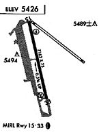
Runways
Runway Summary
| Runways: | 11/29 15/33 H1 |
| Longest Runway: | 15/33 is 7160 ft (2182 m) long |
| Runways with an Instrument Approach: |
TPH Airport Runway Details
| Runway 11/29 | 5660 ft x 50 ft (1725 m x 15 m) | |
| Runway Length Source: | 3RD PARTY SURVEY as of 04/25/2020 | |
| Surface: | Asphalt - Failed condition - No special surface treatment | |
| Runway Edge Lights: | Medium Intensity | |
Runway Weight Bearing Capacity (in thousands of pounds) |
||
| Single Wheel Landing Gear: | 30.0 | |
| Dual Wheel Landing Gear: | 66.0 | |
| Dual Tandem Wheel Landing Gear: | 77.0 | |
Runway 11 |
Runway 29 |
|
Elevation: |
5428.4 | 5410.4 |
Latitude: |
38-04-00.0814N | 38-03-28.0364N |
Longitude: |
117-05-27.5410W | 117-04-29.5857W |
|
Runway True Alignment: |
125 | 305 |
Glide Path Angle: |
0.0 degrees | 0.0 degrees |
Traffic Pattern: |
Left | Left |
Runway Markings Type: |
Basic | Basic |
Runway Markings Condition: |
Fair | Fair |
REIL: |
No | No |
Touchdown Lights: |
No | No |
Centerline Lights: |
No | No |
| Runway 15/33 | 7160 ft x 75 ft (2182 m x 23 m) | |
| Runway Length Source: | 3RD PARTY SURVEY as of 04/25/2020 | |
| Surface: | Asphalt - Failed condition - No special surface treatment | |
| Runway Edge Lights: | Medium Intensity | |
Runway Weight Bearing Capacity (in thousands of pounds) |
||
| Single Wheel Landing Gear: | 30.0 | |
Runway 15 |
Runway 33 |
|
Elevation: |
5430.2 | 5396.0 |
Latitude: |
38-04-03.1167N | 38-02-54.7721N |
Longitude: |
117-05-33.7948W | 117-05-10.5967W |
|
Runway True Alignment: |
165 | 345 |
Glide Path Angle: |
3.0 degrees | 0.0 degrees |
Traffic Pattern: |
Left | Left |
Runway Markings Type: |
Nonprecision Instrument | Nonprecision Instrument |
Runway Markings Condition: |
Good | Good |
Visual Glide Slope Indicators: |
2-Light PAPI On Left Side Of Runway | |
REIL: |
No | No |
Touchdown Lights: |
No | No |
Centerline Lights: |
No | No |
Threshold Crossing Height: |
41 |
| Helipad H1 | 48 ft x 48 ft (15 m x 15 m) | |
| Runway Length Source: | STATE as of 06/05/2017 | |
| Surface: | Asphalt - Failed condition - Aggregate friction seal coat | |
Helipad H1 |
||
Elevation: |
5420.1 | |
Latitude: |
38-03-45.5084N | |
Longitude: |
117-05-40.7487W | |
Glide Path Angle: |
0.0 degrees | 0.0 degrees |
Runway Markings Type: |
Nonstandard (other than numbers only) | |
Runway Markings Condition: |
Good |
Services
Fuel Available: |
100LL, Jet A |
Landing Fees: |
No |
Parking: |
Tiedowns available |
Other Services: |
Glider tows |
Maps & Diagrams
TPH Sectional
Flight Planning
at skyvector.com
at skyvector.com