Location
Latitude: |
39-45-21.9000N (39.756083) |
Longitude: |
084-50-33.7000W (-84.842694) |
Elevation: |
1139.8 feet MSL (347 m MSL) |
Magnetic Variation: |
5.9 W (as of April 2024 from WMM2020 model) |
Time Zone: |
UTC -5.0 (Standard Time) UTC -4.0 (Daylight Savings Time) |
From City: |
05 N.M. SE of Richmond, Indiana |
Found On: |
Cincinnati Chart |
FAA Region: |
AGL |
Contacts
Manager: |
Publicly owned: |
| RODNEY MAYSE 5169 SR 227 S. RICHMOND, IN 47374 765-983-7296 |
RICHMOND BOAC 5169 SR 227 S. RICHMOND, IN 47375 765-983-7296 |
Operations
Airport Status: |
Operational |
Facility Use: |
Public |
Type: |
Airport |
Activation Date: |
12/1944 |
Control tower: |
No |
Attendance (Months/Days/Hours): |
Months/Days/Hours ALL/ALL/0800-1745 |
Boundary ARTCC: |
ZID (Indianapolis) |
Responsible ARTCC: |
ZID (Indianapolis) |
Lighting Schedule: |
SEE RMK |
Segmented Circle Indicator: |
No |
Traffic Pattern Altitude (MSL): |
2140 feet (652 m) |
NOTAMs Facility: |
HUF |
NOTAM-D Service: |
Yes |
International Airport of Entry: |
No |
Customs Landing Rights: |
No |
Military Landing Rights: |
Yes |
Civil/Military Joint Use: |
No |
Based Aircraft
| Single Engine: | 36 |
| Multi Engine: | 2 |
| GA Helicopters: | 4 |
Annual Operations (as of 12/31/2018)
| Total Operations: | 14720 | |
| Air Taxi: | 294 | 2.0% |
| GA Local: | 12512 | 85.0% |
| GA Itinerant: | 1767 | 12.0% |
| Military Aircraft: | 147 | 1.0% |
Communications
| CTAF: | 122.700 |
| Unicom: | 122.700 |
| Approach: | COLUMBUS 118.425 118.425 118.425 118.425 |
| Departure: | COLUMBUS 118.425 118.425 118.425 118.425 |
| AWOS-3: | 121.225 (765-983-1903) |
Fixed Based Operators (FBOs) & Fuel
(Click on a business for detail)
Please help us keep this information up to date. This is a FREE SERVICE just like everything else on Airport Guide! If you see that a business needs to be added, modified, or deleted please fill out our Update Form.
To add, modify, or delete a business click here.
Please help us keep this information up to date. This is a FREE SERVICE just like everything else on Airport Guide! If you see that a business needs to be added, modified, or deleted please fill out our Update Form.
Area Code: 317 |
| Business Name | Frequency | Phone | Fuel Grade |
|---|---|---|---|
| Aerodrome Sky Sports, LLC
Update FBO info |
800-554-5867, 966-0383 | 100LL, Jet A | |
| Bd of Aviation
Update FBO info |
Unicom 122.7 | 983-7297 | 100LL, Jet A |
Flight Service Stations
| Primary | Alternate | |
| FSS on Field: | N | |
| FSS Name (ID): | Terre Haute(HUF) | |
| Frequency: | ||
| Toll Free Phone: | 1-800-WX-BRIEF |
Instrument Procedures / Charts
FAA Terminal Procedures valid from 0901Z 03/21/24 to 0901Z 04/18/24.
There are various types of charts available for an airport. They are listed in the Page Type column. Here is a legend for those types:
APD - Airport Diagram
DP - Departure Procedure Charts
HOT - Hot Spots
IAP - Instrument Approach Procedure Charts
MIN - Minimums
STAR - Standard Terminal Arrival Charts
| Page Type | Page Name | Volume | Action Since Last Cycle |
|---|---|---|---|
| IAP | RNAV (GPS) RWY 06 | EC-2 | |
| IAP | RNAV (GPS) RWY 24 | EC-2 | |
| IAP | RNAV (GPS) RWY 33 | EC-2 | |
| MIN | TAKEOFF MINIMUMS | EC-2 |
Terminal Procedures are only available for airports in several countries with more being added all the time. If you are looking for a specific country's charts, please send an email to support(at)airportguide.com stating the country name. This will be used to prioritize the implementation.
Navigation Aids (Navaids) near RID
| Dist (NM) | ID | Morse Code | Name | Type | Freq | True Hdg | Mag Hdg |
|---|---|---|---|---|---|---|---|
| 0.2 | RID | . _ . . . _ . . | Richmond | DME | 110.6 | 109 | 115 |
| 13.3 | SQ | . . . _ _ . _ | Pnthr | NDB | 227 | 275 | 281 |
| 15.2 | OXD | _ _ _ _ . . _ _ . . | Oxford | NDB | 282 | 169 | 175 |
| 23.2 | UWL | . . _ . _ _ . _ . . | New Castle | NDB | 385 | 288 | 294 |
| 23.9 | HKF | . . . . _ . _ . . _ . | Hook Field | NDB | 239 | 130 | 136 |
| 24.0 | AT | . _ _ | Bruny | NDB | 315 | 76 | 82 |
| 25.8 | DQN | _ . . _ _ . _ _ . | Dayton | VOR-DME | 114.50 | 52 | 58 |
| 26.2 | HAO | . . . . . _ _ _ _ | Hamilton | NDB | 260 | 151 | 157 |
| 26.2 | MW | _ _ . _ _ | Onida | NDB | 223 | 113 | 119 |
| 30.1 | DAY | _ . . . _ _ . _ _ | Dayton J M Cox-Day | VOT | 111.00 | 73 | 79 |
| 31.2 | HLB | . . . . . _ . . _ . . . | Batesville | NDB | 254 | 218 | 224 |
| 33.7 | JN | . _ _ _ _ . | Balll | NDB | 365 | 319 | 325 |
| 36.0 | AI | . _ . . | Video | NDB | 394 | 301 | 307 |
| 36.5 | FFO | . . _ . . . _ . _ _ _ | Patterson | TACAN | 109.20 | 83 | 89 |
| 38.4 | MIE | _ _ . . . | Muncie | VOR-DME | 114.40 | 318 | 324 |
| 39.2 | MDE | _ _ _ . . . | Madeira | NDB | 379 | 144 | 150 |
| 42.7 | LUK | . _ . . . . _ _ . _ | Cincinnati | NDB | 335 | 146 | 152 |
| 42.7 | UR | . . _ . _ . | Burln | NDB | 321 | 175 | 181 |
| 43.5 | LUK | . _ . . . . _ _ . _ | Cincinnati Muni/Lunken | VOT | 108.40 | 153 | 159 |
| 44.9 | CVG | _ . _ . . . . _ _ _ . | Cincinnati | VORTAC | 117.30 | 171 | 177 |
Nearby Airports with Fuel
Notices to Airmen (NOTAMS)
Remarks
| A16 | AFT HR 765-993-4139. |
| A57-06 | APCH RATIO 34:1 TO DTHR. |
| A57-24 | APCH RATIO 24:1 TO THR. |
| A58-15 | 10 FT CROPS 105 FT L OF RWY END CNTRLN. |
| A58-24 | 10 FT CROPS 110 FT L & R OF RWY END CNTRLN. |
| A58-33 | 10 FT CROPS 100 FT L & R OF RWY END CNTRLN. |
| A81-APT | ACTVT REIL RWY 06 & 24; PAPI RWY 06 & 24; MIRL RWY 06/24 & 15/33 - CTAF. |
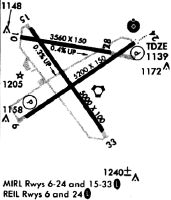
Runways
Runway Summary
| Runways: | 06/24 15/33 |
| Longest Runway: | 06/24 is 5502 ft (1677 m) long |
| Runways with an Instrument Approach: | 24 |
RID Airport Runway Details
| Runway 06/24 | 5502 ft x 150 ft (1677 m x 46 m) | |
| Runway Length Source: | 3RD PARTY SURVEY as of 11/12/2009 | |
| Surface: | Asphalt - Excellent condition - Saw-cut or plastic grooved | |
| Runway Edge Lights: | Medium Intensity | |
Runway Weight Bearing Capacity (in thousands of pounds) |
||
| Single Wheel Landing Gear: | 30.0 | |
| Dual Wheel Landing Gear: | 40.0 | |
| Dual Tandem Wheel Landing Gear: | 60.0 | |
Runway 06 |
Runway 24 |
|
Elevation: |
1134.7 | 1138.2 |
Latitude: |
39-45-05.9154N | 39-45-36.9782N |
Longitude: |
084-51-00.3561W | 084-50-02.5451W |
|
Runway True Alignment: |
055 | 235 |
ILS Type: |
LOC/GS | |
Glide Path Angle: |
3.0 degrees | 3.0 degrees |
Traffic Pattern: |
Left | Left |
Runway Markings Type: |
Precision Instrument | Precision Instrument |
Runway Markings Condition: |
Good | Good |
Object at End: |
ROAD | TREES |
Object Height: |
18 | 72 |
Distance from End: |
320 | 1740 |
Object Centerline Offset: |
510 ft. left of centerline | 730 ft. right of centerline |
Visual Glide Slope Indicators: |
4-Light PAPI On Left Side Of Runway | 4-Light PAPI On Left Side Of Runway |
REIL: |
Yes | Yes |
Touchdown Lights: |
No | No |
Centerline Lights: |
No | No |
Threshold Crossing Height: |
26 | 47 |
Threshold Elevation: |
1134.3 | |
Displaced Threshold: |
300 | |
Threshold Latitude: |
39-45-07.6110N | |
Threshold Longitude: |
084-50-57.1982W | |
Declared Distances |
||
Take Off Run Avbl. (TORA): |
5500 | 5500 |
Take Off Distance Avbl. (TODA): |
5500 | 5500 |
Actual Stop Dist. Avbl. (ASDA): |
5500 | 5500 |
Landing Dist. Avbl. (LDA): |
5200 | 5500 |
| Runway 15/33 | 4999 ft x 100 ft (1524 m x 30 m) | |
| Runway Length Source: | 3RD PARTY SURVEY as of 11/12/2009 | |
| Surface: | Asphalt - Excellent condition - No special surface treatment | |
| Runway Edge Lights: | Medium Intensity | |
Runway Weight Bearing Capacity (in thousands of pounds) |
||
| Single Wheel Landing Gear: | 30.0 | |
| Dual Wheel Landing Gear: | 40.0 | |
| Dual Tandem Wheel Landing Gear: | 60.0 | |
Runway 15 |
Runway 33 |
|
Elevation: |
1126.7 | 1139.8 |
Latitude: |
39-45-42.7316N | 39-45-02.2003N |
Longitude: |
084-50-54.5687W | 084-50-17.9842W |
|
Runway True Alignment: |
145 | 325 |
Glide Path Angle: |
0.0 degrees | 0.0 degrees |
Traffic Pattern: |
Left | Left |
Runway Markings Type: |
Nonprecision Instrument | Nonprecision Instrument |
Runway Markings Condition: |
Good | Good |
Object at End: |
TREES | |
Object Height: |
66 | |
Distance from End: |
2550 | |
Object Centerline Offset: |
510 ft. left of centerline | 730 ft. right of centerline |
Touchdown Lights: |
No | No |
Centerline Lights: |
No | No |
Services
Airframe Repair: |
Minor |
Powerplant Repair: |
Minor |
Fuel Available: |
100LL, Jet A |
Landing Fees: |
No |
Parking: |
Tiedowns available |
Maps & Diagrams
RID Sectional
Flight Planning
at skyvector.com
at skyvector.com